Megalopotamos
| Megalopotamos | ||
|
Location of the Megalopotamos and its tributaries |
||
| Data | ||
| location | Crete , Rethymno Regional Unit | |
| source | Several spring streams and springs, u. e.g.: 35 ° 13 '56 " N , 24 ° 23' 50" E |
|
| muzzle |
Limni Preveli , in the Mediterranean Sea Coordinates: 35 ° 9 ′ 8 ″ N , 24 ° 28 ′ 26 ″ E 35 ° 9 ′ 8 ″ N , 24 ° 28 ′ 26 ″ E |
|
| Mouth height |
0 m
|
|
| length | up to about 18 km | |
| Left tributaries | Kissamos | |
|
Old Bridge (παλαία γέφυρα) or Great Bridge (μεγάλη γέφυρα) |
||
The Megalopotamos ( Greek Μεγαλοπόταμος , large river ') is a year-round water-bearing brook in the south of the Greek Mediterranean island of Crete . To give a name: all streams on Crete are called ' rivers ' in the local language , even those that have no water in summer. The brook, often also called Kourtaliotis (Κουρταλιώτης), after the rocky gorge Kourtaliotiko , which it flows through, is one of the last ten continuously water-bearing rivers in Crete. In the Geographike Hyphegesis by Klaudios Ptolemaios the brook is probably mentioned under the ancient name Massalia potamou (Μασσαλία ποταμοῦ, spring river ').
geography
The megalopotamos is about fifteen kilometers long. The entire length of the water is located in the area of the municipality of Agios Vasilios ( Rethymno regional district ), for which it plays an outstanding role as a supplier of drinking and industrial water.
Course of the brook
Upper course and Kourtaliotiko Gorge

The Megalopotamos is formed as the confluence of many smaller streams that drain the plain of Agios Vasilios , the northern lowland of the municipality of Finikas . The main tributary rises between Kanevos and Agios Ioannis north of the Kotsifou Gorge .
Many of the streams fall dry in midsummer or are pumped out for irrigation purposes, so that it can happen that the Megalopotamos at the entrance to the Kourtaliotiko Gorge no longer has visible water. The water runs through this gorge between the Kouroupa and Xiro mountain ranges in a southerly direction towards the Libyan Sea .
The beginning of the year-round water flow of the Megalopotamos is an extensive headwaters in the lower third of the Kourtaliotiko Gorge , which always feeds large amounts of water into the stream. The stream, which also has large amounts of water and debris in the upper section in winter, has cut so deeply into the gorge that it normally only exposed layers of water-bearing rock that emerged at sea level. Most of the spring water emerges from the side of the canyon walls to plunge into the stream that flows a few meters below.
A religious legend traces the unusually strong sources back to a Saint Nicholas ( Agios Nikolaos o Kourtaliotis , Άγιος Νικόλαος ο Κουρταλιώτης, for example 'Saint Nicholas the Rattler' or 'the Noisy'), who at this point of the gorge seven times with his shepherd's staff hit the dry rock walls, whereupon seven springs opened.
Another version reports that Agios Nikolaos wanted to persuade a companion living there with him to stay during a period of drought. He touched a rock with his hand and the springs rose from the five points of his fingers. Above the springs, a much-visited chapel honors the saint, which can be reached from the road through the gorge via a long stone staircase. A second smaller chapel with wall paintings is dedicated to Agios Georgios .
The Megalopotamos forms a small pond below the largest springs, into which the water falls over a waterfall. From there it flows more calmly past a small concrete dam towards the southern exit of the gorge. The stream is shielded by plane trees and other smaller trees.
Southern lowland
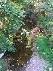
The natural stream turns south of the gorge exit of the Kourtaliotiko at the ruins of an old oil mill on the west bank, which formerly belonged to the Preveli monastery , slightly to the south-east. The character of the stream has meanwhile changed due to the heavy reed growth, the banks are hardly accessible due to the lush vegetation.
Here in the plain is the only structural transition over the stream. The Old Bridge (παλαία γέφυρα) or Great Bridge (μεγάλη γέφυρα) was built between 1850 and 1852 during the Turkish rule. It is one of the largest stone bridges in Crete with a height of 7.60 meters and an arch width of 13.30 meters. Since the 1970s there has been a piped concrete dam directly in front of her downstream, which also enables motor vehicles to cross the stream. If it leads to high water in winter, this dam is completely flooded. From the bridge, gravel roads lead in the direction of Drymiskos (Δρύμισκος) and Drymiskiano Ammoudi (Δρυμισκιανό Αμμούδι), the easternmost sea beach in the municipality of Finikas.
About 500 meters south of the bridge on the slope of the southwest bank of the Megalopotamos are the ruins of the Lower Monastery of Preveli, Kato Moni Preveli , also called Moni Mega Potamou . The monastery church there is dedicated to John the Baptist ( Agios Ioannis Prodromos ). The year 1594 is written on the bell tower. The monastery was abandoned in the 19th century. Opposite the remains of the building, the Megalopotamos joins on the northeast side of the stream with another mostly water-bearing stream, the Bourtzoukos or Kissamos , which, fed from the great springs of Spili , runs past Mixorouma through the neighboring Frati Gorge to the south.
Lower course
Behind the inlet of the Bourtzouko , particularly large areas with cypresses, holm oaks, carob and olive trees spread out on both sides, the borders of which again approach the banks of the stream. The river bed is rocky thereafter until the water in several cascades in the canyon of Preveli flows. The upper entrance to the gorge is hardly accessible, as large boulders often block the path, between which pools of water have formed.
After passing through a bottleneck about a kilometer north of the mouth, the walls of the gorge recede a little and give the megalopotamos space to irrigate the bank vegetation made up of oleander and mastic bushes, eucalyptus and the first palm trees that form a small forest at the mouth of the stream. The bank is passable on foot from the bottleneck to the sea on the west side, from about 500 meters in front of the beach also on the east bank. The entire lower Bachtal is still owned by the monks of the Preveli monastery .
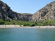
From about 400 meters in front of the mouth, the Megalopotamos forms the so-called pond or lake of Preveli ( Limni Preveli ). Due to the very flat course from here onwards and the constant sand alluvium by the sea, which dammed up the water of the stream in front of the beach, an elongated, approximately 15,000 m² freshwater lagoon has formed. The banks are lined with reeds, flowering oleander bushes and the palm forest that characterizes the estuary. The small chapel of Agios Savvas from the 14th to 15th centuries stands between the trees on the east bank of the stream just before the beach .
Since the palm beach of Preveli attracts many tourists and some locals earn their living by renting pedal boats on the "lake", they are often also busy with increasing the congestion effect at the estuary by sandwork. In addition to palm trees, many tamarisk trees provide shade right on the beach , under which loungers are offered for beach guests. Excursion boats from Plakias bring day-trippers to the palm beach, so that this is always quite busy in the season. In addition to the sea route, there are two other beach accesses from land, one from a parking lot not far from the road to the rear monastery of Preveli, Piso Moni Preveli , west above the gorge, and an easier one over the eastern shore rocks from the neighboring Drimiskiano Ammoudi beach .
On the west side of Megalopotamos there is a small tavern under the palm trees behind the beach. There is no bridge over the stream in the estuary area. You have to wade through it to get to the other bank. The outflow of the stream into the Libyan Sea is on the rocks on the western side of the beach.
From August 21st to 22nd, 2010 there was a forest fire in the lower gorge behind the beach, in which the palm grove burned down completely. The local representative of the environmental protection organization WWF, Kaloust Paragamian, said that about 70 percent of the trees are still alive. However, it can be assumed that the tree population will only recover from the fire in 20 to 30 years.
- Views of the Preveli Gorge
Flora and fauna
The valley of the Megalopotamos is one of the most important ecosystems in Crete. Due to the diversity of the individual stream sections, it is home to a representative selection of the island's endemic plant species. It is also a retreat for various animals, especially a nesting place for a large number of bird species.
Frogs, freshwater crabs , various water-bound insect species and water snails live in calmer waters on the creek banks of the Kourtaliotiko gorge , which is rather poor in vegetation and where the plants are predominant . Rock pigeons ( Columba livia ), ravens such as the common raven ( Corvus corax ), and the lesser horseshoe bat ( Rhinolophus hipposideros ), a species of bat, nest in the caves of the gorge . Finally, rare species of birds of prey such as the golden eagle ( Aquila chrysaetos ), the bearded vulture ( Gypaetus barbatus ) and the griffon vulture ( Gyps fulvus ) can be observed.
Above and below the bridge on the middle course of the Megalopotamos you can find bank vegetation u. a. Rushes , reeds ( Phragmites australis ) and Spanish reeds ( Arundo donax ). As usual with Cretan streams, plane trees ( Platanus orientalis ) line large parts of the stream, which in summer stands out as a green band from the landscape. Especially south of the bridge are also cypress ( Cupressus sempervirens ), Kermes oak ( Quercus coccifera ), carob trees ( Ceratonia siliqua ) and olive trees ( Olea europaea ).
Finally, on the lower reaches, there are tamarisks ( Tamarix ) and the Cretan date palms (Phoenix theophrasti) . The palm forest of Preveli is next to Vai on the east coast of Crete the most important occurrence of this type of date palm on the island and has therefore been placed under nature protection. Oleander ( Nerium oleander ), mastic ( Pistacia lentiscus ) and planted eucalyptus ( Eucalyptus ) complete the lush vegetation character in front of the mouth of the Megalopotamos in addition to the strong reed growth .
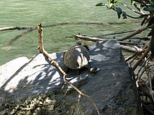
Frequent, but seldom seen inhabitants, especially of the lower section of the stream, are the up to 25 cm long West Caspian tortoises ( Mauremys rivulata ). After rainfall, torrents often wash the animals into the sea. In contrast to other Greek islands, there are no water snakes in Megalopotamos . Eels and trout live in the lower reaches, and freshwater crabs can be seen more often in and around the stream than in the upper reaches.
In addition to the eagles and vultures, which are rather rare in the lower gorge of the Megalopotamos , one can often see a coastal bird of prey from Crete, the Eleanor's falcon ( Falco eleonorae ). Furthermore, the Preveli gorge is inhabited by various species of swallows, sparrows and finches. To name among them are barn swallows ( Hirundo rustica ), martins ( Delichon urbicum ), house sparrows ( Passer domesticus ), willow sparrows ( Passer hispaniolensis ), goldfinches ( Carduelis carduelis ), chaffinch ( Fringilla coelebs ) and greenfinch ( Carduelis chloris ).
After all, different migratory birds can be found on the lake of Preveli, depending on the season. B. the mallard ( Anas platyrhynchos ), but also native Chukar chickens ( Alectoris chukar ).
Economic use
Before the Megalopotamos leaves the Kourtaliotiko Gorge , considerable amounts of water are diverted into a canal system to the southwest. Because of the excellent quality of the water near the Agios Nikolaos springs , the canal system supplies the nearby villages with drinking water. Large amounts are also used to irrigate the southern valleys of Finikas below 250 meters. The fertility and rich vegetation of the region is due solely to the Megalopotamos . The water channel fed by the brook flows through almost the entire south-eastern area of Finikas with a length of over 20 kilometers and irrigates gardens as well as fruit and olive plantations. The canal system is led with the main canal in a westerly direction to the lower Kotsifou gorge above Plakias . Two smaller canals to the southeast extend as far as Schinaria and beyond Gianniou .
supporting documents
- Oliver Rackham, Jennifer Moody: The making of the Cretan landscape. Manchester University Press 1996, ISBN 0-7190-3647-X ( book review ( September 28, 2007 memento on the Internet Archive ))
- Giorgis N. Petrakis: Plakias. Selena Publishing 2006
- G. Desipris, K. Santorineou: Crete - Rethymno. Publishing house Michalis Toubis SA 1997
- Antonis Sp. Vassilakis: Crete. Verlag I. Mathioulakis & Co. (the author is an archaeologist)
- Crete. ADAC travel guide, ADAC publishing house 2003
Individual evidence
- ^ William Smith (ed.): Dictionary of Greek and Roman Geography . Walton and Maberly, London 1854 (English, online [accessed October 11, 2012]).
- ↑ Claudii Ptolemaei ; Karl Friedrich August Nobbe : Geographia . tape 1 . Leipzig 1843, p. 219 (Latin, online [accessed October 11, 2012]).
- ↑ 83 forest fires in one day - Greece newspaper of August 23, 2010. (No longer available online.) Www.griechenland.net, archived from the original on May 12, 2013 ; Retrieved August 24, 2010 . Info: The archive link was inserted automatically and has not yet been checked. Please check the original and archive link according to the instructions and then remove this notice.
- ↑ Fire damaged Cretan palm beach. derstandard.at, accessed on August 24, 2010 .
- ↑ ΤΟ ΕΓΚΛΗΜΑ ΣΤΗΝ ΠΡΕΒΕΛΗ: Έδωσαν 1,4 εκατ. ευρώ για πυρανίχνευση, αλλά το πρόγραμμα δεν υλοποιήθηκε ποτέ! www.cretalive.gr, accessed August 24, 2010 .


