
Michalovy Hory
| Michalovy Hory | |||||
|---|---|---|---|---|---|
|
|||||
| Basic data | |||||
| State : |
|
||||
| Region : | Plzeňský kraj | ||||
| District : | Tachov | ||||
| Municipality : | Chodová Planá | ||||
| Area : | 181.5867 ha | ||||
| Geographic location : | 49 ° 54 ' N , 12 ° 47' E | ||||
| Height: | 515 m nm | ||||
| Residents : | 79 (2011) | ||||
| Postal code : | 348 13 | ||||
| License plate : | P | ||||
| traffic | |||||
| Street: | Planá - Teplá | ||||


Michalovy Hory (German Michelsberg , formerly Michaelsberg ) is a village in the municipality of Chodová Planá in the Okres Tachov in the Czech Republic.
Geographical location
The village is located in western Bohemia on the left bank of the Kosový potok ( Wunschelbach ) in a hilly landscape of the Tepler highlands north of the town of Planá u Mariánských Lázní (German plan ). The Lazurový vrch ( Lazurberg , 650 m nm) rises to the north .
history


In the former mining town of Porschitschi ( Poříčí ) there was already substantial mining going on before it was destroyed by the Hussites . The owners of the Plan estate , to which Porschitschi belonged in the 14th century, still maintained the Michalšperk castle on the neighboring Lazurberg in 1340 , of which only ruins have remained in modern times. In 1437 the mountain area was first mentioned when King Sigismund enfeoffed his chancellor Kaspar Schlick with it.
The mountain town of Michaelsberg was recreated around 1500 by German miners on the site of the extinct Porschitschi and first mentioned in writing in 1505. Michaelsberg , which had previously been owned by two brothers from the von Seeberg family and from Zdislav Berka von Dubá , experienced its heyday at the beginning of the 16th century when it passed into the possession of Count Moritz, son of Stefan Schlick. King Ludwig II confirmed the freedom of the mountains already granted to the previous owners with the privilege of being able to use the extracted metals of all kinds in any way. According to the oldest loan books, Count Moritz Schlick had a mine and a deep tunnel on the Lazurberg in operation here in 1542. Here, most of the silver from which Count Schlick had their coins minted was extracted from the 'Glück mit Freuden' mine . In 1593 Michaelsberg was raised to a mountain town. In 1660 Count Franz Ernst Schlick gave the town its own coat of arms and the authority to seal with green wax.
Many citizens of Michelsberg had joined the Reformation . When most Protestants had to leave Bohemia after the Battle of White Mountain , this led to the closure of pits in Michelsberg and an associated economic recession. In addition to silver ore, formerly u. a. also mined lead ore , nickel ore , copper ore , cobalt and spike . There are two iron-containing mineral springs near the site. Mining came to a standstill in the first half of the 19th century. Most of the men hired themselves abroad as building craftsmen, and the young people spent the summer doing a job in neighboring Marienbad . Other sources of income also offered the lace making, a string factory and a paper factory.
After the abolition of patrimonial Michelsberg formed from 1850 a market town in the old Bohemian Pilsner district and judicial district of Plan . In 1853 the place received full city rights. From 1868 the city was part of the newly formed district Plan .
After the First World War , Michelsberg was added to the newly created Czechoslovakia in 1919 . Due to the Munich Agreement Michelberg belonged from 1938 to 1945 for the district of Tachov , Region of Eger , in the Reich District of Sudetenland the German Reich . After the end of World War II , the German population from the region and the city sold .
In 1950 Michalovy Hory was assigned to the Okres Mariánské Lázně. In the course of the municipal reform in 1961, the villages Boněnov, Domaslavičky, Hostíčkov and Výškovice were incorporated into Michalovy Hory, at the same time the municipality became part of the Okres Tachov . On January 1, 1980 Michalovy Hory was incorporated into Chodová Planá.
The number of residential houses has steadily declined since the middle of the 19th century; from 162 (1869) to 115 (1950) and 39 (2001).
Demographics
| year | Residents | Remarks |
|---|---|---|
| 1785 | k. A. | 137 houses |
| 1830 | 856 | in 160 houses, according to other information 850 inhabitants |
| 1837 | 898 | in 160 houses |
| 1855 | 1,200 | |
| 1869 | 927 | |
| 1880 | 923 | |
| 1890 | 853 | |
| 1900 | 819 | |
| 1910 | 776 | |
| 1921 | 769 | including 765 German residents |
| 1930 | 724 | |
| 1939 | 626 |
| year | 1950 | 1961 | 1970 | 1980 | 1991 | 2001 |
| Residents | 80 | 200 | 153 | 85 | 47 | 70 |
coat of arms
The city coat of arms, awarded in 1660, showed the archangel Michael fighting the dragon and underneath the usual mining insignia (hammer etc.).
Sons and daughters of the place
- Adolf Johann Heisinger (1808–1859), clergyman, abbot of the Geras monastery since 1852
Location views
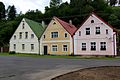
Townhouses

Residential buildings

Part of the main street

Part of the main street
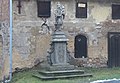
St. Anthony statue


literature
- Johann Ferdinand Schmidt von Bergenhold : Clear history of mining and metallurgy in the Kingdom of Bohemia from the oldest to the most recent times, along with a history of the individual still in operation as well as the abandoned mining companies in this country. Prague 1873, pp. 190–191 .
- Johann Gottfried Sommer : The Kingdom of Bohemia . Volume 6: Pilsen Circle. Prague 1838, pp. 220-221, paragraph 3 .
Web links
- Short description of the place on the Chodová Planá website
- Detailed web presentation of the spolek Michalovy Hory
Individual evidence
- ↑ http://www.uir.cz/katastralni-uzemi/694011/Michalovy-Hory
- ^ Kaspar von Sternberg : Outline of a history of the Bohemian mines . Volume 1, Prague 1836, p. 259 .
- ^ Eduard Senft: History of the city and rule plan in Bohemia . Plan 1876, pp. 314-315 .
- ↑ a b c d e f g Historický lexikon obcí ČR 1869 - 2005 - 1. díl, pp. 332–333
- ↑ Jaroslaus Schaller : Topography of the Kingdom of Bohemia . Volume 9: Pilsner Kreis , Prague and Vienna 1788, pp. 179–180, item 2) .
- ↑ Yearbooks of the Bohemian Museum of Natural and Regional Studies, History, Art and Literature . Volume 2, Prague 1831, p. 203, item 11) below.
- ^ Carl E. Rainold: Taschen-Reise-Lexikon für Böhmen . Prague 1833, p. 358 .
- ↑ Johann Gottfried Sommer : The Kingdom of Bohemia . Volume 6: Pilsen Circle. Prague 1838, p. 220 .
- ^ Pierer's Universal Lexicon . Volume 11, Altenburg 1860, p. 237 .
- ^ Sudetenland Genealogy Network
- ^ A b Michael Rademacher: German administrative history from the unification of the empire in 1871 to the reunification in 1990. Tachau district. (Online material for the dissertation, Osnabrück 2006).
- ↑ Directory of the personnel of the secular and regular clergy of the episcopal St. Pölten diocese . St. Pölten 1858, p. 255 .