
Milreu

| ||
Location of the Villa von Milreu in the Algarve, southern Portugal |


The ruins of Milreu in the Portuguese community of Estoi represent one of the most important examples of Roman living and economic culture at the beginning of the 1st century AD outside the heartland of Italy and are therefore a representative example of a growth and development during the course of the Roman Empire thriving country estate, the villa rustica in Hispania . With a long history of research, Milreu is not only the focus of archaeological investigations, but is also a worthwhile excursion destination in the Algarve in southern Portugal.
location
Located in the Algarve province of southern Portugal, the facility is approx. 7–9 km north of the port city of Faro , the former Roman Ossonoba . Reports by ancient authors such as Strabo (III 2.5) and Pliny (IV, 116) describe Ossonoba as one of the most important port cities in the region. At the foot of the Serra de Monte Figo coastal mountains , Milreu is in close proximity to the town of Estoi . The landscape is characterized by orchards, orange groves and fertile gardens, which are fed by sufficient naturally occurring water. Favored by a particularly mild climate, this area offers the ideal basis for agriculture. Findings from Roman times confirm this condition, which continues to the present day.
Research history


André de Resende suspected in 1770, based on marble columns and other finds from Roman times, that Milreu was the Roman Ossonoba. The basis of this misunderstanding was a report by the Arab geographer Al-Rassis from the 16th century. Al-Rassis described there the ruins of Ossonoba verifiably. De Resende believed he was looking at these ruins when he came across the remains of Milreus. This mistake was to persist into the 19th century.
The first archaeological excavations took place from the middle of the 19th century in 1877 under the direction of Sebastião Phillipes Martins Estácio da Veiga . Furthermore, according to the opinion of Ossonoba, Estácio da Veiga initiated the most extensive excavation of the complex to date. All the building units of the villa known today, with the exception of Speicherbau H, were excavated at that time and recorded on a site plan, which for a long time remained the only source of information. Large parts of the uncovered villa were already filled in again after the excavation campaign was over. Subsequent terracing for agricultural use destroyed some areas of the ancient building stock. The result was the focus on the building units that had remained visible, in particular pars urbana A, the bathing complex B and the sanctuary G. In 1897, the archaeological field work in Milreu was continued under the direction of JM Pereira Botto . This time Botto concentrated on the bathing complex B and the cult building G as well as its extensions. The results of the investigations presented in 1889 also included a building plan that, unlike that of Estácio da Veiga, was less detailed. In 1932 the area was classified as a historical monument of national importance, Monumento Nacional , and has been a listed building since then. Four decades after the completion of the Bottos excavation, the field work was resumed in 1941 under M. Lyster Franco. The background to this was the need to clean and conserve the ruins. This took place on the initiative of the former monument protection authority Direcção-Geral dos Edifícios e Monumentos Nacionais (DGEMN).
In the same decade, the mistake about the incorrect identification of Ossonoba with Milreu was finally to be corrected. Abel Viana , school inspector and private scholar, uncovered the remains of a Roman forum in 1940 in the area of the cathedral in Faro's old town. There was also a reference to the lack of sea access of the supposed Ossonoba. Consequently, according to Viana, Milreu had to be a rural settlement in the hinterland of the port city of Ossonoba. It was then examined by the German Archaeological Institute (DAI) until the mid-1990s . Primarily the buildings erected in the 3rd century were found. In 1971, new systematic excavations and restorations of the remains of the mosaic began in this context. In 1997, a joint project consisting of the Fritz Thyssen Foundation in Cologne, which provided supporting funds, and the Goethe University Frankfurt under the direction of Felix Teichner , as well as in close cooperation with the IPPAR in Faro and the universities of Jena, was dedicated , Galway in Ireland and Budapest, an archaeological study on the history and economic forms of Roman villas in the province of Lusitania . The quarry stone plinths and clay walls of the 1st century, however, initially remained unexplored.
Today the area is open to the public in the form of an open-air museum and informs visitors about the living and economic culture of the Romans during the imperial era in the Algarve, Portugal.
Building history
history
The area around the Milreu site was not only known to us in Roman times. Prehistoric and early historical settlement areas can be localized around the complex . The reason for this may have been the trade route to the north, which can be traced into the Alentejo . Another criterion related to the permanent establishment at this exclusive location is the enormous abundance of water in the region. As mentioned before, it forms the existential basis for successful agricultural yield and the profitable economic benefits associated with it.
In the historical settlement area of Guardians , to Ptolomaios or the Conii, to Strabo, today's Algarve, it can already be seen from the 2nd century BC. Recognize a slow but steady change in the area of residential and economic culture. Despite unrest in the 2nd and 1st centuries BC In the northern and central part of the province of Hispania Citerior on the westernmost edge of the ancient world, the southern area was largely spared. This may have been due to several factors. On the one hand, the mountain range running to the north and the river Anas provided a natural barrier and, on the other hand, the long rocky coastline offered protection from incursions and unrest. Given these favorable conditions, the entire region was soon to be of central, economic and political importance, not least due to the establishment of the coastal towns of Ossonoba and Balsa . As mentioned earlier, Ossonoba is a port city. It formed the economic trading center of the region. Garum , wine and oil were sold among others . Sources of supply were latifundia in the surrounding area and hinterland, including that of Milreu.
Roman villa

A roman villa comprised the pars urbana , the residential part, and the pars rustica , the business part. The from Baetica originating Lucius Junius Columella Moderatus also introduces a third part: pars fructuaria . The current area around the central peristyle courtyard is a building design from the 2nd century when a new building with a large peristyle and atrium was erected over the older villa . This villa was used until the end of the 3rd century. The following conversion primarily affected the business unit. Accommodation for the servants and a winery have to be identified. In addition to the winery and a huge oil mill with five presses, the farm yard also included three cellar rooms for storing oil. The peristyle enclosed a garden with a water basin. On one narrow side, the private apartments with individual heated rooms are grouped around a small atrium with a fountain . On the opposite side, a large, rectangular room with an apse served as a triclinium . There was also a noteworthy bathing complex, the Balneum .
pars urbana - living (A)
In the design of the living area, the wealth and social self-image of the respective owner was reflected. Due to the rural, secluded location, the client was not necessarily subject to structural restrictions, so there were hardly any modularized building types, unlike, for example, in urban residential building. Nevertheless, there were some architectural elements that can be recognized in one form or another in the pars urbana . The magnificent entrance area, the vestibule , the walls of which are painted, the floor decorated with mosaics and the water basins opposite each other, which were once covered by semi-domes, give an idea of what an imposing impression the entrance must have made on the visitor.
All areas of the residential complex can be easily reached from the peristyle . With a size of 24.30 m by 28 m and a column width of 3 m, it offered sufficient comfort for idleness or business. Here, too, the floor is decorated with mosaics. The representation ranges from simple geometric patterns to the depiction of figurative maritime content. The adjoining rooms were accessed from the peristylum. The open portico with a view through the rows of columns allowed a view of the garden and the large water basin. Originally there were 8 columns on the respective long sides and 6 columns on the narrow sides. This distinctive building type with a central peristylum can be found not only comparable in the heartland itself, but also in written sources. In the 1st century AD , Pliny the Younger wrote about the architectural and artistic ideas of the leading Roman social class with regard to the design of rural property, which absolutely required representative staging.
The triclinium , located on the west side of the peristyle, consisted of a total of 11 m long suite of rooms with an anteroom and a square central room and the round apse 6 m wide to the east. The rich ornamentation of decorative mosaics can only be guessed at first, as only a few remains were found here.

However, small U-shaped walls have been preserved in the back of the hall. These are the clinae , benches for lounging and eating.
In addition to food and drink, it was quite the custom to invite your guests to a bath in the thermal baths (B) . This was reached via the vestibule. In addition to the bathing facility, there is also a changing facility, the apodyterium , which is unusually large for a villa. The equipment included small niches in which there was space for taking off and storing clothes, as well as for providing ointments and oils for skin care. The facility in Milreu dates from the 3rd century. In order to be able to supply the entire building complex with enough water, one could either have collected rainwater in cisterns or, for example, created a reservoir. In the case of Milreus, the water came from the hillside. There were several springs here, where Estoi is today.
pars rustica - farming
Already in the first settlement phase, the pars urbana and the pars rustica were clearly distinguishable from each other. Thanks to the water-rich region, large vineyards and olive plantations could be built. After the plant was already in operation in Augustan times, the winery and the oil press were built in the first century. The surplus generated in this way was used for the renovation of the residential building. Some parts of the commercial buildings were also renewed and expanded. Including storage rooms, access ramps and an entire farm yard including residential accommodation in the southeast of the complex. In the time of the tetrarchy , the residential complex was expanded to the north and for this reason the winery was relocated to a winery section that was moved to the east. In addition, a three-aisled warehouse was built in the west. The first reductions in the Valentian-Theodoric period took place in the area of the oil mill and the southeastern farmyard. Nevertheless, the plant remained in operation in the post-Roman period.
Oil mill (C)

The oil press in the north of the facility is unique in its size and completeness in Roman Lusitania . Originally consisting of five pressing units, two cellars and a bottling plant, the villa began pressing olive oil as early as the second half of the 1st century AD . During the process, the liquid was conveyed from the press to the cellars via a pipe system made of lead and clay pipes, then packed and transported away via a courtyard adjacent to the west.
The first renovations at the end of the 2nd century brought some extensions that improved the general course of business; Among other things, an olive mill , which took the place of the bottling plant between the western courtyard and the oil presses. With the extension of the peristyle courtyard adjoining to the south at the end of the 3rd century, the entrance area had to be redesigned. During the heyday of the facility, five presses worked here next to each other and produced oil, which was stored in three large storage cellars in so-called Dolia .
In the middle of the 5th century the mill was reduced in size again. After a damaging event, the bottling cellar and the olive mill were abandoned. The original press halls and receiving basement were reduced to half the area. During the Visigothic period of the 6th and 7th centuries, the production area continued to shrink until the last press floor was finally destroyed by a fire.
Winery (D)
The winery is part of how the oil press of the essential farm buildings of the plant. It borders directly on the northeastern part of Villa urbana . The older parts were built in the first three centuries of the Imperial Era, including a press and storage room. After renovation work at the time of the Tetrarchy , the old winery had to give way to the residential building. The new winery, which was offset to the east on the parallel south-eastern farm wing, was only partially examined, as it is largely located under the listed estate and an orange plantation. Due to isolated ceramic finds, this extension could be dated to the 2nd century AD at the earliest. The production facility remained in operation until late antiquity . In post-antique times, the winery moved to the northern part of the former residential complex, as shown by a production basin in the southeast corner of the room.
Housing and farmyard (F)
Since an orange plantation hinders the exploration of the complex to the east, the extent of this southern wing of the building is only known to us from the plans of the excavations from the 19th century. Only four, almost square rooms have been excavated, which combine to form a single structure and which are oriented towards the east of the cult building. Some of them are laid out with floor mosaics, so they can be interpreted as living spaces. The remaining part of the wing, which adjoins further to the east, is oriented differently and only incompletely captured by probes. This part of the building is the older one, which in an earlier construction phase moved further west under the later cult building.
Together with the parallel north wing of the younger winery, this residential building enclosed the large farm yard on the east side of the complex.
Commercial building (H)
Only remnants of this building have been preserved in the south of the villa. A facade width of over 12 m was determined by probing the Frankfurt research project on the part of the DAI. It is a three-aisled structure. One recognizes parallels to a three-aisled commercial and warehouse building on the neighboring Cerro da Vila . In the south, the stratigraphic findings indicate a slope that was still steeply sloping in antiquity.
Mausoleums (E)
To the east of the villa are two mausoleums . Both grave structures have a core construction made of Opus caementitium as well as an independently set staircase base. While the mausoleum in the west has a central chamber with grave niches intended for 10 urns , the east grave building is probably intended for sarcophagi . The western columbarium is dated to the 2nd century by ceramic finds; the eastern building by a coin of Divus Claudius II not before the second half of the 3rd century
Auditorium (G)

The assembly hall or the cult building describes a water temple that was initially used for agriculture between the 2nd and the end of the 3rd century and was finally subject to a renovation phase that was completed in the first half of the 4th century. The east of the peristyle courtyard has now been furnished with maritime mosaics and a richly decorated cult building has been erected across the street, which has been preserved up to the vaulted base . Post-Roman finds attest to the continued use of the building as an early Christian church in the 6th and 7th centuries and later as an Islamic burial site between the 8th and the beginning of the 10th century. The following description refers analogously to the post-Constantine building phase at the beginning of the 4th century.
A portal led into the inner courtyard, in the center of which lies the cult building with the colonnade raised on a podium. Countless marble fragments and polychrome fish mosaics testify to its once unusual colors . The fragments found made it possible to reconstruct the building, which was designed according to a simple scheme. The cella covers a square floor plan with a cross vault . An apse with colored mosaics in the vaulted dome is added. The building has all the characteristics of the classic temple . In the 19th century a hexagonal water basin was still visible in the center of the cella, an indication of a water cult ( nymphaeum ) practiced here. The construction program is remarkable because at a time when a large number of Christian churches were being built on the Iberian Peninsula, a pagan sanctuary was built here by a large landowner at great expense.
Post-Roman use
In the 5th century, the villa's constant growth stagnated and the complex began to decline gradually. During the period of the Visigothic kingdoms, the total area continued to shrink despite some renovations. The former pars urbana was newly divided into independent residential areas, which were now aligned with the auditorium, which is now used as a Christian church . Complemented by a christening piscina , the building now served as a religious center. In the former Temenos area , a small cemetery and a mausoleum were set up for the dead.
Due to its natural location, the facility remained populated even after antiquity and the failure of the last oil press in the 8th century. This is evidenced by some buildings using drywall technology , which date back to the early Islamic period of the Umayyads at a significantly higher level . A solid tower-like construction in the former peristyle courtyard was the focus. The basin of a wine or oil press in the former northeast wing of the residential building continued the agricultural activity. The former assembly hall was also used for religious purposes. As Islamic inscriptions prove, the people of this time adapted their written culture and language to the new, now Islamic rulers of the area. The names appearing in the same inscriptions, however, are still influenced by Greek. They are typically written for the grave inscriptions of the time and were dedicated to the rest of the Roman population, a group called "al-Hamami" in scripture, which translates as "from the warm springs". Since all Islamic remains were lost in the early phase of the excavation, it can no longer be said whether the last function went beyond an Islamic burial site. The settlement activity ended with the collapse of the barrel vault of the cult building in the 10th century due to a severe earthquake.

manor
Only in the 13th century after the final reconquest of the Iberian peninsula by the Christian kingdoms did the repopulation take place. In the course of the 15th century settlement activity increased again and a fortified manor with loopholes was built on the northeast corner of the former villa. It is the best-preserved example of fortified rural architecture in the Algarve, and it stands to this day.
Monument protection
Under conservation , the protection of cultural monuments and culturally important overall systems understands. The aim is to ensure that monuments are permanently preserved and not falsified, damaged, impaired or destroyed, and that cultural assets are permanently secured. The legal definition and framework conditions for monument protection are determined by monument law. Monument protection is part of the protection of cultural assets. Measures that are necessary for the creation and maintenance of cultural monuments are called monument preservation.
The Portuguese Institute for Architectural Cultural Heritage, Instituto Português do Património Arquitectónico, was initially commissioned with the preservation of the Portuguese buildings worthy of monument protection and other Portuguese cultural treasures and their integration into the Portuguese cultural landscape. In 1994 the IPPAR received further rights in the area of the reconstruction of individual buildings and is subordinate to the Ministry of Culture. In 1992 a comprehensive database of monuments was initiated, which not only included the Portuguese world cultural heritage and the palaces maintained under state supervision, but also numerous private buildings and natural monuments in all parts of the country. A restructuring took place from 2007 to 2008 as part of the Programa de Reestruturação da Administração Central do Estado (PRACE) , a program for the restructuring of the central administration of the state, from which the authority Instituto de Gestão do Património Arquitectónico e Arqueológico (IGESPAR) emerged.
Monument protection in Portugal also means coastal protection policy. For too long, natural alluvial areas such as the dunes of the coastal regions have been built on in order to develop infrastructure and tourism. The consequence is the constant rise in the water level and thus the destruction of cultural monuments.
museum

Today the facility is open to interested visitors all year round in the form of an open-air museum. With the completion of the reception and information center in 2001 and the installation of a structured signage guide, which is written bilingually in Portuguese and English, the area is excellently developed in terms of didactic communication and thus an important contribution to the provision of general cultural assets for the public within the framework of museum principles.
Located on the western edge of the area, it is easily recognizable for visitors and designed to be barrier-free . Conceptually, it adapts perfectly to the natural landscape of the archaeological area. The center consists of an exhibition room that explicitly addresses the chronology of the building units and is therefore of great relevance as an introductory theme. It is the attempt to transport a world into the present and to give the visitor an idea of the way of life of the Romans in the Algarve. In addition to the building units that can be visited, the archaeological collection also includes luxurious artefacts that are evidence of a distinctive lifestyle. If there is also a need for more in-depth knowledge of the content, this can be met in the in-house museum shop. In addition to publications, it also offers other products. This was made possible by the patronage of IPPAR, the Portuguese Institute for Architectural Patrimony.
photos
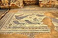
Floor mosaic

Exposed remains of the wall in Milreu

Wall mosaic detail


.jpg)
rating
A large number of rich villa complexes can be found locally, the standards of which are quite comparable with those of the heartland of Italy. Particularly noteworthy features of the Roman Villa Milreus were its prestigiously decorated residential complex with furnishings of ancient imperial busts, a water cult building in the form of a temple and the pleasantly well-preserved facilities of a winery and an oil mill .
literature
- Portuguese Institute of Archaeological Patrimony (ed.): Roteiros da Arquelogia portuguesa: Milreu - ruins. Lisboa 2002.
- Thomas G. Schattner (Ed.): Archaeological guide through Portugal (= cultural history of the ancient world . Vol. 74). Philipp von Zabern, Mainz 1998, ISBN 3-8053-2313-1 , pp. 204-207.
- Felix Teichner : Between land and sea - Entre tierra y mar. Studies on the architecture and economy of rural settlements in the south of the Roman province of Lusitania. Stvdia Lvsitana 3 (MNAR) / Madrid Contribution (DAI) 2008, ISBN 978-84-612-7893-0 , p. 93 ff.
- Walter Trillmich , Annette Nünnerich-Asmus (Ed.): Hispania Antiqua - Monuments of the Roman Age. von Zabern, Mainz 1993, ISBN 3-8053-1547-3 , esp. pp. 72–80, cat, pp. 233–235, color plates 2 and 3, fig. 104.
Web links
- official website: Monomentos do Algarve
- tourism
- Wikitravel
- Vila Romana, Milreu
- Video: Interview with Rui Pereira
- Video: tour
Individual evidence
- ↑ F. Teichner: Between Land and Sea - Entre tierra y mar. Studies on the architecture and economy of rural settlements in the south of the Roman province of Lusitania. (= Studia Lusitana. Volume 3). (MNAR) / Madrid Contribution (DAI) 2008, p. 95.
- ↑ F. Teichner 2008, pp. 96-102.
- ↑ F. Teichner 2008, pp. 102-107.
- ↑ F. Teichner 2008, pp. 114–123.
- ↑ F. Teichner 2008, pp. 181-206.
- ↑ F. Teichner 2008, pp. 102-107.
- ↑ F. Teichner 2008, pp. 207–213.
- ↑ F. Teichner 2008, pp. 232-235.
- ↑ F. Teichner 2008, pp. 243-250.
- ↑ F. Teichner 2008, pp. 268–270.
- ↑ F. Teichner 2008, pp. 240–243.
- ↑ F. Teichner 2008, pp. 250-268.
- ↑ F. Teichner 2008, p. 256.
- ↑ F. Teichner 2008, p. 107.
- ^ T. Hauschild, F. Teichner: Milreu ruins. (= Roteiros da Arqueologia Portuguesa. Volume IX). Lisboa 2002, p. 59.
- ↑ lfd.hessen.de