
Mischabel
| Mischabel | ||
|---|---|---|
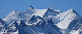
 Mischabel, view of the west or Mattertal side , seen from the Weisshornhüttenweg |
||
| Highest peak | Cathedral ( 4545 m above sea level ) | |
| location | Canton Wallis between Mattertal and Saas Valley | |
| part of | Valais Alps | |
|
||
| Coordinates | 632 523 / 104765 | |

The Mischabel [ mischáhbl ] is a mountain range in the Valais Alps . It lies between the Mattertal in the west and the Saas valley in the east and is the third highest mountain massif in the Alps after the Mont Blanc massif and Monte Rosa . Its main peak , the cathedral , is 4545 m above sea level. M. the highest mountain in Switzerland , the entire base of which lies within the borders of the Valais .
Naming
The origin of the name Mischabel is unclear. In part, the view is that he is of the three-pronged "Mischtgabla" (High German: pitchfork ) derived the local farmers, according to others he is from the invaded around the year 900 to the Valais Saracens come ( Mudjabal , Arabic, mountain range '.)
Four-thousanders
The Mischabel consists of (from south to north):
- Täschhorn , 4491 m
- Cathedral , 4545 m
- Lenzspitze , 4294 m , formerly also called Südlenz
The summit of the northwest adjoining the Lenzspitze Nadelgrat , connected by the needle yoke ( 4208 m ) are also added to the mixing Abel:
- Nadelhorn , 4328 m
- Pin horn , 4241 m
- Hohberghorn , 4219 m
- Dürrenhorn , 4034 m
The four-thousand-meter peaks of the Allalin group , adjoining the Täschhorn to the south, connected by the Mischabeljoch ( 3847 m ), are partly included in the Mischabel (from north to south):
- Alphubel , 4206 m
- Allalinhorn , 4027 m
- Rimpfischhorn , 4198 m
- Strahlhorn , 4190 m
glacier
On the Mattertal side or the west side of the Mischabel you can find (from north to south):
- Nadelgrat, Lenzspitze, Dom and Täschhorn
- Allalin group
On the Saas Valley side or the east side of the Mischabel you can find (from north to south):
- Nadelgrat, Lenzspitze, Dom and Täschhorn
- Allalin group
Huts
On the Mattertal side or the west side of the Mischabel you can find (from north to south):
- Nadelgrat, Lenzspitze, Dom and Täschhorn
- Allalin group
On the Saas Valley side or the east side of the Mischabel you can find (from north to south):
- Nadelgrat, Lenzspitze, Dom and Täschhorn
- Allalin group
High trails
On the Mattertal side and the west side of the Europaweg leads under the Mischabel, on the Saas Valley side and the east side of the Höhenweg Balfrin . The Europahütte is also located at the intersection of the Europaweg and Domhüttenweg .
photos
The following pictures show the Mischabel from the west and north side, with the individual viewpoints moving further and further away from the Mischabel to the northeast:

View at 3292 m above sea level M. from the Hörnligrat of the Matterhorn to the Mischabel (right) and the Weisshorn group (left).

View of the Mischabel above the Weisshornhütte .

Summit view from the Augstbordhorn to the Mischabel.
View from Moosalp to the Mischabel; Mountain peaks from left to right: Lenzspitze (in the background), Nadelhorn, Stecknadelhorn, Dom (in the background), Hohberghorn

Mischabel from Kasteltschuggen ( Zeneggen ).

Mischabel from Zeneggen .

Mischabel from Bruchegg in Belalp .
Mischabel from the Massatal .

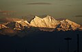
Mischabel and Matterhorn from Riederalp .

Mischabel, Matterhorn and Weisshorn group from Steibenchriz in Bellwald .


The following pictures show the Mischabel from the east side, with the individual viewpoints moving further and further away from the Mischabel to the east and south:
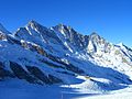
View in winter 2006 from Mittelallalin to Mischabel, Täschhorn on the left , then Dom and Lenzspitze .

Mischabel from Saas-Fee .

Mischabel from Kreuzboden above Saas-Grund .
Mischabel from Milan .


Web links
- Mischabel on the ETHorama platform
- Video impressions of the Mischabel group from the Moosalp location