Mitterwöhr (Münchsmünster)
|
Mitterwohr
Municipality Münchsmünster
Coordinates: 48 ° 46 ′ 6 ″ N , 11 ° 39 ′ 12 ″ E
|
|
|---|---|
| Height : | 355 m |
| Postal code : | 85126 |
| Area code : | 08402 |
Mitterwöhr is a part of the community Münchsmünster in the Upper Bavarian district of Pfaffenhofen an der Ilm . Before the regional reform in 1978, it was the center of the former municipality of Wöhr with a sports field, the Wöhr volunteer fire department , the former elementary school, the cemetery and the St. Vitus Church. The Mitterwöhrers also provided Martin Kellerer as the last mayor of Wöhr .
Geographical location
The village is located on the southern Danube floodplains between Vohburg and Pförring . It is about one kilometer from Vohburg and about two kilometers from Münchsmünster .
In the northeast of the village is the Gerich pond. It is a typical gravel and groundwater pond that can be found everywhere in the Mitterwöhr area.
history
Name origin
Mitterwöhr or the name Mittawīhr used in today's Bavarian dialect can be traced back to the name Wehr from reliable sources .
The conversion of the vowel can be justified with the rounding in the Bavarian dialect. In contrast to rounding, when rounding, a vowel change occurs from High German "ö" to "e" or "īh". The Bavarian makes use of it to avoid the umlauts in the pronunciation (another example: “listen” becomes “h e r () n” or “h ea n”).
The name "Wehr" appears on a section of the "Bavarian Landtaflen" by Philipp Apian , an Ingolstadt professor during the Renaissance . The map shows the “Vohburg” located on the Danube Island, the “Hartacker” to the south-east and the village “Wert” and describes the topographical situation in 1568.
On the one hand, it can be assumed that the name is derived from the Old High German word 'weride' for island, shore land or river island. The proximity of the Danube and Ilm supports this assumption. A similar naming can also be observed for the place names "-werder" or "-wörth".
On the other hand could be hypothesized that "military" or "Forbid" from the Germanic term warjan and the German fight back is to be derived. Both words express the obstacle, deterring, defending and protecting. The loopholes in the cemetery walls of Sankt Vitus could also point to this. According to the presumption, the “weir” could have been a position built in the Middle Ages to defend Vohburg to the east.
Middle Ages and Modern Times
The place Mitterwöhr is mentioned for the first time in a document dated January 8, 1350. In the genealogical collection of the Bavarian noble families of Johann Michael Wilhelm von Prey (1740) it is described in detail that initially the nobles from the house Grill von Wörtt and Marching owned Wöhr in the Middle Ages ("Grillo de Wörth", 1258). After that, when Gutta Grill married Wolfhart von Schilwazhausen around 1310, ownership of the grill passed to the Schilwazen . It is not clear whether Wöhr was already divided into a three-part place in an "upper", "lower" or "middle word". Nor is this clear from the genealogies of the resident ministerials . Georg von Schilwazhausen, the last male Schilwaz, died in 1485. His sister Ursula then sells her inheritance - with all the property (including those in Wöhr) and the debts - to Duke Albrecht IV. The Wise . Both families, the Schilwazen and the Grill, are now extinct in the male line. Her line continues through the female progeny, for example through the sex of the Coo von Membach .
When the political communities were formed in 1808/1818 , the wasteland of Griesham and the villages of Mitter-, Nieder- and Oberwöhr were combined to form an independent municipality of Wöhr. As part of the regional reform , this municipality was incorporated into the Münchsmünster municipality on January 1, 1978.
20th century
Due to the canalization of the Danube at the beginning of the 20th century, the picture of the Mitterwöhrer Donauauen changed significantly: the small Danube , which until then ended shortly after Vohburg (height of Dünzing / new Danube bridge), was lengthened and now flowed across from Wackerstein Castle into the Danube. This was done primarily with the intention of avoiding the impending flooding caused by a backwater when the Danube floods.
With the relocation of the small Danube to the east, the municipality of Wöhr and its fire brigade were given the task of protecting the dams for the new, 2 km long section. To ensure safety in the event of a flood, the Eiserne Steg was built in 1903. It is a good 33 meters long and 1.50 meters wide.
The dialect poet and local researcher Max Kirschner , born in 1906, was the main teacher at the elementary school in Wöhr in the old school building on Vohburger Strasse for 33 years . In 1973 he was made an honorary citizen of the former municipality of Wöhr and three years later also an honorary citizen of Vohburg .
On January 1, 1978, the previously independent municipality of Wöhr Münchsmünster was added.
21st century
In the middle of the first decade, a new building area was designated in Mitterwöhr. This is located on the specially newly built Max-Kirschner-Straße and allowed the place to grow further to the southeast.
Saint Vitus Church
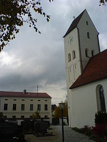
The church of St. Vitus is surrounded by an old cemetery . This is by a wall with loopholes limited, but they are closed. Older parts were used for the current building of the church. In addition, the new building was lengthened to 1.5 times the original structure and raised by around 65 cm.
The church tower is built in the late Romanesque style and has three floors. It is located to the west of the church and is closed off by a gable roof. The church is a branch church of the parish Sankt Sixtus from Münchsmünster.
economy
Mitterwöhr is very much influenced by agriculture . The place is bordered by fields in all directions. The importance of agriculture is also evident in the naming of Gärtner Straße.
But other types of economy also characterize the 160-inhabitant town, because, for example, the local car manufacturer Audi (plant in Münchsmünster) is increasing the population of the small town.
Traffic and roads
Mitterwöhr is not directly on the B16a . It can be reached by coming from Vohburg after about a kilometer to the left and following the course of the road or Vohburger Straße. Vohburger Straße surrounds the center of Mitterwöhr like a loop and passes the old school building and the St. Vitus church.
At the southern vertex of Vohburger Straße, the path branches off to the south and thus to Oberwöhr, which is located directly on the B16a.
At the western entrance to the village there is an oak tree that is over 100 years old and is responsible for the street name of the Eichenweg and with its 50 meters towers over most of the houses in Mitterwöhr.
Two streets in Mitterwöhr were named after local people: One is Max-Kirschner-Strasse and the other is Gärtner Strasse.
This street at the north end of Mitterwöhrs was called Donaustraße before the 1978 regional reform, but was renamed Gärtner Straße because of the already existing Donaustraße in Münchsmünster, which is based on the profession of the local farmer Heckmeier.
Recreation
Since the place, like many other communities in the Danube valley, has nearby gravel deposits, these were mined and a gravel pit dug north of the village. This filled with groundwater and is now called the Gerich pond.
It is a typical gravel pond and now attracts citizens from Vohburg and Münchsmünster in the summer months. Even windsurfers from Mitterwöhr have discovered the pond for themselves and have made it the primary recreational area of Mitterwöhr, along with the many bathing people and fishermen .
North of the Court-pond is located the southern dams of the Danube , which the flat terrain around Mitterwöhr from floods in floods protect. There is also a cycle path that runs from Vohburg downstream and thus towards Neustadt and Regensburg . Here the cyclist encounters the untouched flora and fauna of the Danube floodplains.
The Wellenbach (an Ilm branch), also known as the “little Danube”, meanders towards the Danube and is bordered by the Danube dams. The “Eiserne Steg” connects both dams exactly north of Mitterwöhr and is the first option after leaving Vohburg to cross the “Little Danube” on foot or by bike.
There is also a soccer field at the Schützenheim in Mitterwöhr, but it is rarely used because Mitterwöhr does not have a soccer club. The adjacent hill can also be used as a sledge hill in winter and, besides the small elevation on which the church stands, is the only notable elevation in Mitterwöhr, Niederwöhr and Oberwöhr.
Honorary citizen
- Max Kirschner (1906–1992), dialect poet and local researcher, appointed in 1973
Individual evidence
- ^ Vohburg - Contributions to the natural and cultural history of Vohburg , City of Vohburg, 2002, p. 89
- ↑ http://www.koeblergerhard.de/der/DERW.pdf
- ↑ Municipality and districts: Mitterwöhr ( page no longer available , search in web archives ) Info: The link was automatically marked as defective. Please check the link according to the instructions and then remove this notice. on www.muenchsmuenster.de
- ^ Von Prey: Collection for the Genealogy of the Bavarian Nobility, in alphabetical order. Volume 12. , 1740, page 189r
- ^ Von Prey: Collection for the Genealogy of the Bavarian Nobility, in alphabetical order. Volume 12. , 1740, page 190v
- ^ Von Prey: Collection for the Genealogy of the Bavarian Nobility, in alphabetical order. Volume 24. , 1740, page 255
- ↑ Hund, Wiguleus: Bayrisch Stammen-Buch , [Ed. 1585 - 1586], vol .: 1,, Ingolstadt, 1585 [VD16 H 5927], page 329
- ↑ a b Federal Statistical Office (ed.): Historical municipality register for the Federal Republic of Germany. Name, border and key number changes in municipalities, counties and administrative districts from May 27, 1970 to December 31, 1982 . W. Kohlhammer, Stuttgart / Mainz 1983, ISBN 3-17-003263-1 , p. 586 .
- ↑ Stadtarchiv Vohburg (ed.): 100 years "Eiserner Steg". Historical supplement No. 9/2003 ( Memento of the original from March 4, 2016 in the Internet Archive ) Info: The archive link was inserted automatically and has not yet been checked. Please check the original and archive link according to the instructions and then remove this notice.


