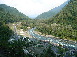
Msymta
|
Msymta Мзымта |
||
|
On the middle reaches of the Msymta |
||
| Data | ||
| Water code | RU : 06030000312109100000790 | |
| location | Krasnodar region ( Russia ) | |
| River system | Msymta | |
| Headwaters |
Greater Caucasus 43 ° 35 ′ 42 ″ N , 40 ° 36 ′ 48 ″ E |
|
| Source height | 2472 m | |
| muzzle |
Black Sea Coordinates: 43 ° 24 ′ 53 " N , 39 ° 55 ′ 29" E 43 ° 24 ′ 53 " N , 39 ° 55 ′ 29" E |
|
| Mouth height | 0 m | |
| Height difference | 2472 m | |
| Bottom slope | 28 ‰ | |
| length | 89 km | |
| Catchment area | 885 km² | |
| Outflow at the Krasnaya Polyana gauge |
MQ |
33.2 m³ / s |
| Outflow at the Kepsch gauge |
MQ HHQ |
45.6 m³ / s 764 m³ / s |
| Right tributaries | Psluch, Atschepse | |
| Big cities | Sochi | |
The Msymta ( Russian Мзымта ) is a 89 km long river on the southwest side of the Greater Caucasus in the Russian region of Krasnodar .
course
The Mzymta entfließt a small mountain lake northwest of the 2,970 m high mountain Lojub in 2472 m altitude, on the territory of the reserve Big Caucasian Sapowednik , part of the UNESCO World Heritage -area Western Caucasus . It flows around the mountain to the east and reaches Lake Kardywatsch , which is 1838 m high on the tree line . From the lake it flows between the main Caucasus ridge and the Gagrinski ( Gagra ridge ) and Aibga ridge, which run parallel to the southwest, through a narrow, unpopulated valley in a north-westerly direction. The highest peak of the main ridge near the river is the aforementioned Lojub, the Gagra ridge - the 3257 m high Agepsta .
Above Krasnaya Polyana , the venue for some of the competitions of the 2014 Winter Olympics , the Msymta near Esto-Sadok reaches the inhabited area. At Krasnaya Polyana, it turns in a south-westerly direction and flows through a still narrow, section-wise gorge-like valley to its confluence with the Black Sea in Adler , the most south-eastern part of Sochi .
The most important tributaries are the Psluch and Atschepse, which flow from the right into the Msymta above Krasnaya Polyana from the main Caucasus ridge.
The Msymta runs along its entire length a few kilometers from the border between Russia and Abkhazia, which is striving for independence from Georgia . Between the upper reaches of the Msymta and the Awadchara valley , a tributary of Lake Riza in Abkhazia, lies the approximately 2,100 m high Achuk-Dara pass , over which a road that can be used in summer leads.
Hydrography
The catchment area of the Msymta covers 885 km². The mean monthly water flow at Krasnaya Polyana is 33.2 m³ / s, at Kepscha 45.6 m³ / s (maximum 764 m³ / s), and around 50 m³ / s near the mouth. The spring flood during the snowmelt lasts into the summer, shorter sporadic summer floods are due to precipitation.
Near the mouth, the river is up to 100 meters wide and over a meter deep.
Infrastructure and economy
The Msymta is not navigable. A small hydropower plant with an output of 29.6 megawatts was built near Krasnaya Polyana between 1947 and 1950 . The barrage also serves to regulate the river during floods.
The road from Adler to Krasnaya Polyana and on to the winter sports area above Esto-Sadok runs through the valley over the right bank of the river. The river is crossed by several bridges, including near its mouth by the M27 highway and the railway line that runs from Tuapse via Sochi along the Black Sea coast to the Abkhazian capital Sukhumi (formerly on to Tbilisi ). Sochi Airport is located in the immediate vicinity of the river on the flood plain that it created .
