
Murauer Schlossberg
| (Murauer) Schlossberg | ||
|---|---|---|
 Stadtberg, castle , parish church ; out of the valley, behind the foot of the Stolzalpe |
||
| height | 860 m above sea level A. | |
| location | Murau , Styria | |
| Mountains | Murtal Mountains | |
| Dominance | 0.25 km → Lärchberg | |
| Notch height | 42 m ↓ Murauer Strasse | |
| Coordinates | 47 ° 6 '42 " N , 14 ° 10' 9" E | |
|
||
| Type | Riegelberg | |
| rock | Murau lime | |
| Age of the rock | Old Paleozoic (around 500 million years) | |
| particularities | Height approximately, overbuilt | |

The Murauer Schlossberg is the city mountain of Murau in the upper Mur Valley in Upper Styria , Styria .
Location and landscape
The Schlossberg (in the addresses still Schloßberg ) is the old settlement core of the city of Murau . It is located at the confluence of the Ranten valley with the Murtal, directly on the left bank (north) of the Mur , out of the valley flows from the left into the Mur at the foot of the Rantenbach . The hill rises about 60 meters above the Mur and the lower town, the upper town is halfway up on a slope terrace .
The summit is built over with the castle (Ober-) Murau (Schloßberg 1), with the old farmhouses to the west, the parish church (Matthäuskirche) with parsonage (Schloßberg 8, 9) faces the Mur . On the south side around the castle are the gardens with Baroque and English gardens , the north side is the forest park. The street around the actual Schloßberg includes Schwarzenbergstrasse to the east - Lichtensteinstrasse at the station bridge - Anna-Neumann-Strasse to the south on the Mur - Raffaltplatz - Gustav-Baltzer-Strasse to the east and Murauer Strasse (B97) to the north.
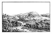
The Riegelberg region Schlossberg - Leonhardsberg (left, with Grünstels Castle ) with the old areas of the Ice Ages; into the valley, behind the Lärchberg , from the right the Rantenbach (around 1830)

, Parish church and castle at the railway bridge seen


history
The area was settled as early as the Bronze and Roman Ages (the mountain could be a typical Celtic settlement hill, but there is no evidence; a Roman stone has been preserved). In a prime location, the mountain controls both the route from Upper Styria via the Turrach to Carinthia and Northern Italy, as well as that via Obertauern into Salzburg, both of which are old roads in the Alpine region. The first medieval castle was built by Ulrich von Liechtenstein around 1232 . In the war between Habsburg and Ottokar Přemysl 1276–1278 this was destroyed and then rebuilt. The early Gothic St. Matthew's Church was built until 1296. In 1298 Murau received city rights. Georg Ludwig zu Schwarzenberg , the successor to Anna Neumann , built the renaissance castle in place of the old castle in 1628–1643 .
geology
The mountain consists of Murauer Kalk , an old Paleozoic limestone marble , which is roughly 500 million years old, and represents deposits of the predecessor sea of the Thetys, the Palaeotethys ( Murau Paleozoic ). The surrounding mountain feet of Stolzalpe , Lärchberg and Frauenalpe are also made of this rock . To the north there is lime phyllite from the B97 .
The Schlossberg, together with the Leonhardsberg (Green Rock), forms a characteristic Riegelberg to the south , a special glacial-morphological valley shape. At the end of the Ice Age, the Radstädter / Schladminger Tauern Glacier, which carved out the Krakau and Rantental, was more active than the tongue of the Mur main valley, which branched off towards Turrach and Flattnitz and gave off a lot of ice there. Therefore, the Ranten valley deepened more and left a rock bar up the Mur across the valley. This steep step in the valley was then broken through by the powerfully flowing post-glacial Mur. The Köglhof cataract built over by the Murau power plant, a 10-meter high Mur rapids, was probably part of the base of this barrier. This means that a pre- / interglacial valley floor has been preserved in the Schlossberg - Leonhardsberg summit corridor , whereby the Schlossberg was also freed from the mountain spur of the Lärchberg by the level of the B97 - there is an even higher level, the Schlossberg is a little lower. The terrace level at 830 m above sea level. A. upstream of the Mur is therefore the older valley floor ( lower terrace of the Pleistocene ), the lower one at the foot of the valley and towards the Rantenbach is late to post-glacial alluvial cone ( Holocene ), down the valley at St. Egidi is 810 m above sea level. A. Pleistocene again.
Individual evidence
- ^ History of Murau. murau.steiermark.at
- ↑ One suspected here the Noreia or Immurio given in the Tabula Peutingeriana .
- ↑ cf. Andreas Thurner: Geology of the Frauenalpe near Murau. In: Jahrbuch der Geologische Bundesanstalt 86 (1936), esp. 5th main profile marked path Murau-Frauenalpe , p. 320 ff, full article p. 303–336, PDF on ZOBODAT there in particular p. 18, illus . Profiles last page .
- ↑ a b Hans Spreitzer: Size values of the extent of the glacial deep erosion (primarily using the example of the upper Styrian Mur region). In: Mitteilungen des Naturwissenschaftlichen Verein für Steiermark 93 (1963), p. 117 f, and Fig. 2 Extent of the glacial clearance in the main valley and in the large secondary valleys in the upper Styrian Mur region , p. 155, 1st profile Rantental , entire article p 112–119, PDF on ZOBODAT there in particular p. 6 f resp. 4th