Nöstlbach
|
Nöstlbach ( settlement ) locality cadastral community Nöstlbach |
||
|---|---|---|
|
|
||
| Basic data | ||
| Pole. District , state | Linz-Land (LL), Upper Austria | |
| Pole. local community | St. Mary | |
| Coordinates | 48 ° 9 '58 " N , 14 ° 14' 46" E | |
| height | 291 m above sea level A. | |
| Residents of the village | 1488 (January 1, 2020) | |
| Area d. KG | 4.06 km² | |
| Post Code | 4502 Saint Mary | |
| prefix | + 43/7227 | |
| Statistical identification | ||
| Locality code | 09982 | |
| Cadastral parish number | 45517 | |
| Counting district / district | Nöstlbach (41020 002) | |

|
||
| Source: STAT : index of places ; BEV : GEONAM ; DORIS | ||
Nöstlbach is a cadastral municipality and a settlement of the municipality of St. Marien in Upper Austria . Nöstlbach lies between Neuhofen an der Krems and Nettingsdorf (city of Ansfelden ) an der Krems . With its own stop for the Pyhrnbahn, there is a direct train connection between Linz and Selzthal . The good traffic connection (Pyhrnbahn, approx. 4 km to the Haid motorway junction) has resulted in a large influx.
The infrastructure of the place corresponds to that of a rural place. There are supermarkets and shopping centers within a few kilometers.
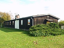
In Nöstlbach there is a branch church of the parish St. Marien, the barrack church .
history
The earliest written document is from 888 and is "Nezzilapach". The name goes back to nezzila ( Old High German for nettle).
Personalities
- Josef Laßl (1915–1977), journalist , music and literary critic as well as poet and writer

