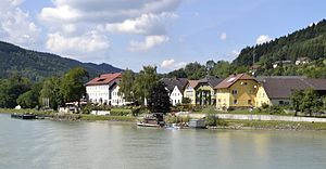
Niederranna (municipalities Hofkirchen, Pfarrkirchen)
|
Niederranna ( village ) locality |
||
|---|---|---|
|
|
||
| Basic data | ||
| Pole. District , state | Rohrbach (RO), Upper Austria | |
| Judicial district | Rohrbach | |
| Pole. local community | Hofkirchen im Mühlkreis ( KG Marsbach ) | |
| Coordinates | 48 ° 28 '8 " N , 13 ° 47' 20" E | |
| height | 290 m above sea level A. | |
| Residents of the village | 150 (January 1, 2020) | |
| Building status | 63 (2001) | |
| Post Code | 4085 essence bank | |
| Statistical identification | ||
| Locality code | 10945 | |
| Counting district / district | Hofkirchen im Mühlkreis (41 312 000) | |
 Niederranna in summer 2012 |
||
| with Rotte Ufer , localities also in Pfarrkirchen i.Mkr. Danube bridge Niederranna Source: STAT : Place directory ; BEV : GEONAM ; DORIS |
||
Niederranna is a village on the edge of the Danube in the upper Mühlviertel in Upper Austria . The former fishing village is the village of the municipality of Hofkirchen im Mühlkreis , an associated local location is the village of Parishes in Mühlkreis , both in Rohrbach District . The place has an important bridge over the Danube .
geography
|
Niederranna ( Scattered Houses ) locality |
|
|---|---|
| Basic data | |
| Pole. District , state | Rohrbach , Upper Austria |
| Pole. local community | Parish churches in the Mühlkreis ( KG Altenhof ) |
| Coordinates (K) | 48 ° 28 ′ 50 " N , 13 ° 46 ′ 37" E |
| height | 300 m above sea level A. |
| Residents of the village | 1 (January 1, 2020) |
| Building status | 6 (2001) |
| Post Code | 4085 essence bank |
| Statistical identification | |
| Locality code | 11121 |
| Counting district / district | Parish churches in the Mühlkreis (41 327 000) |
| Most of the place belongs to Hofkirchen i.Mkr. Source: STAT : index of places ; BEV : GEONAM ; DORIS ;
(K) Coordinate not official
|
|
The place is about 25 kilometers downstream of Passau , 19 kilometers southwest of Rohrbach , 2½ kilometers southwest of Hofkirchen and 4 of Pfarrkirchen .
The village of Niederranna is around 290 m above sea level. A. Altitude on the alluvial land of the left bank of the Danube, in the upper Danube breakthrough valley in Upper Austria at river kilometer 2195, approx. 8 km above the Schlögener loop . The area belongs to the Danube Gorge and Side Valleys spatial unit . In Niederranna the Danglesbach flows into the Danube.
The Hofkirchen village of Niederranna comprises around 65 buildings with around 170 inhabitants, including the Rotte Ufer on the beach upstream, and the other scattered locations. The village itself has around 50 addresses.
The Ranna , from which the place takes its name, flows upstream from the bank at Rannamühl . There in the valley below the first bend of the Ebenhochstraße (L587) there are still some houses that already belong to the parish of Pfarrkirchen (the whole right side of the valley of the lower Ranna belongs to this parish), and there form an independent village. But today they are no longer permanently inhabited.
|
Kramesau (O, Gem. Neustift i.Mkr. )
Rannamühl (Gem. Neustift im Mkr. ) |
Altenhof (O, parish churches in Mkr.)
Falkenstein (O, Gem. Hofkirchen i.Mkr.)
Leiten (Gem. Hofkirchen i.Mkr.) |
Hundsfülling (O, Gem. Hofkirchen i.Mkr.) |
|
Danube |

|
Marsbach (Gem. Hofkirchen i.Mkr.) |
|
Danube
Kager (O)
Essence bank (O)
(both Gem. Waldkirchen aW , district Schärding ) |
- ∗ between the village and the Pfarrkirchen district
traffic
Niederranna and Wesenufer are connected by an important Danube crossing, the Niederranna road bridge . On the south bank of the Danube, the B130 Nibelungenstraße passes Eferding - Passau . The bridge is the only road crossing between Passau and Aschach , over it you can reach the westernmost Mühlviertel. The L587 Ebenhochstraße goes over the bridge from Kager through Niederranna, and then in serpentines up to Neubau and Eckleinsbach , from where several state roads continue. In Niederranna itself the L1541 Rannariedler Straße branches off, which leads along the bank upstream, climbs up the Rannariedl and then goes to Neustift on the Bavarian border. Down the Danube there is only one municipal road from Niederranna to Marsbach .
Web links
- Niederranna - Information about the place on upperaustria.org
proof
- 41312 - Hofkirchen im Mühlkreis. Community data, Statistics Austria .
- 41327 - Parish churches in the Mühlkreis. Community data, Statistics Austria .

