Niendorf (Ihlow)
|
Niendorf
Ihlow parish
Coordinates: 51 ° 51 ′ 44 " N , 13 ° 22 ′ 55" E
|
|
|---|---|
| Height : | 93 m above sea level NHN |
| Area : | 9.23 km² |
| Residents : | 93 (December 31, 2006) |
| Population density : | 10 inhabitants / km² |
| Incorporation : | December 31, 2001 |
| Postal code : | 15936 |
| Area code : | 033744 |
Niendorf is a district of the municipality of Ihlow in the Teltow-Fläming district in Brandenburg . The place belongs to the Dahme / Mark office and was an independent municipality until December 31, 2001.
location
Niendorf is located in the Lower Fläming , three kilometers southwest of the city of Dahme / Mark and 22 kilometers west of Luckau . Surrounding towns are Rietdorf in the north, Dahme / Mark in the northeast, their district Schwebendorf in the east, Bollensdorf in the southeast, Karlsdorf in the south, Mehlsdorf in the southwest, Ihlow in the west and Illmersdorf in the northwest.
Niendorf is on a municipal road that branches off one kilometer north of the federal highway 102 . State road 71 runs three kilometers east of Niendorf.
history
Niendorf was first mentioned in a document in 1368 under the name Nuwendorff . The place name comes from Middle Low German and means "new village". In 1579 the place was called Nientorp . In its village structure, Niendorf is an anger village with a large village pond in the middle of the Angers. The townscape is characterized by several large four-sided courtyards .
Niendorf belonged to the historical office of Dahme , which came to the Electorate of Saxony as a result of the Peace of Prague in 1635 . From 1657 to 1746 the place belonged to the principality of Saxony-Weißenfels . After the Congress of Vienna in 1815, the Kingdom of Saxony had to cede the area to which Niendorf belonged to the Kingdom of Prussia . There the community was in the district of Jüterbog-Luckenwalde in the administrative district of Potsdam in the province of Brandenburg . In 1819 Niendorf had 105 inhabitants. As a branch church, the village church belonged to Rietdorf, where the local children also went to school. In 1841 Niendorf had 121 inhabitants.
From December 20, 1900 to May 25, 1965, a stop on the Dahme – Jüterbog railway line was in operation in Niendorf . Since July 25, 1952, the community belonged to the Luckau district in the GDR district of Cottbus . After the reunification , Niendorf was initially in the Luckau district in Brandenburg and became part of the Teltow-Fläming district for the district reform in December 1993 . On December 31, 2001 Niendorf was incorporated into Ihlow.
Attractions
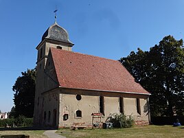
The village church of Niendorf was built in the 18th century and remodeled in a neo-baroque style in 1908 . The altarpiece dates from the 18th century. Niendorf belongs to the parish of Dahme / Mark in the parish of Zossen-Fläming .
Population development
| Population development in Niendorf from 1875 to 2000 | |||||||||||||
|---|---|---|---|---|---|---|---|---|---|---|---|---|---|
| year | Residents | year | Residents | year | Residents | ||||||||
| 1875 | 165 | 1939 | 126 | 1981 | 120 | ||||||||
| 1890 | 154 | 1946 | 191 | 1985 | 111 | ||||||||
| 1910 | 148 | 1950 | 177 | 1989 | 112 | ||||||||
| 1925 | 147 | 1964 | 123 | 1995 | 99 | ||||||||
| 1933 | 138 | 1971 | 125 | 2000 | 88 | ||||||||
Web links
Individual evidence
- ↑ Community and district directory. In: geobasis-bb.de. Land surveying and geographic base information Brandenburg, accessed on December 2, 2018 .
- ↑ Reinhard E. Fischer : The place names of the states of Brandenburg and Berlin: age - origin - meaning . be.bra Wissenschaft, 2005, p. 124 .
- ^ August Schumann : Complete state, post and newspaper encyclopedia of Saxony, Vol. 6. Neudörfel to Ortelsdorf. Gebr. Schumann, Zwickau 1819 Online at Google Books , p. 369
- ↑ Topographical and statistical overview of the administrative district of Potsdam and the city of Berlin. Verlag der Gander'schen Buchhandlung, Potsdam 1841, p. 109 .
- ^ Georg Dehio : Handbook of the German art monuments : Brandenburg. Edited by Gerhard Vinken and others, reviewed by Barbara Rimpel. Deutscher Kunstverlag, Munich / Berlin 2012, ISBN 978-3-422-03123-4 , p. 774.
- ^ Historical municipality register of the State of Brandenburg 1875 to 2005. (PDF; 331 KB) District Teltow-Fläming. State Office for Data Processing and Statistics State of Brandenburg, December 2006, accessed on December 2, 2018 .
