Nowe Miasto Lubawskie
| Nowe Miasto Lubawskie | ||
|---|---|---|

|
|
|
| Basic data | ||
| State : | Poland | |
| Voivodeship : | Warmia-Masuria | |
| Powiat : | Nowe Miasto Lubawskie | |
| Area : | 11.61 km² | |
| Geographic location : | 53 ° 25 ' N , 19 ° 36' E | |
| Residents : | 10,891 (Jun. 30, 2019) |
|
| Postal code : | 13-300 | |
| Telephone code : | (+48) 56 | |
| License plate : | NNM | |
| Economy and Transport | ||
| Street : | Toruń - Milomłyn | |
| Next international airport : | Danzig | |
| Gmina | ||
| Gminatype: | Borough | |
| Residents: | 10,891 (Jun. 30, 2019) |
|
| Community number ( GUS ): | 2812011 | |
| Administration (as of 2015) | ||
| Mayor : | Józef Blank | |
| Address: | Rynek 1 13-300 Nowe Miasto Lubawskie |
|
| Website : | www.nowemiastolub.pl | |
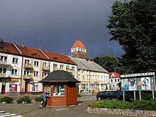
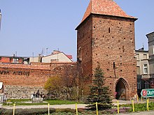
Nowe Miasto Lubawskie [ 'nɔvɛ' mjastɔ lu'bafskʲɛ ] ( German Neumark in West Prussia ) is a town in the Polish Warmian-Masurian Voivodeship with about 11,000 inhabitants .
Geographical location
The city is located in the historic Kulmerland landscape , in the former West Prussia on the Drewenz , about 55 kilometers southeast of Marienwerder ( Kwidzyn ) and 54 kilometers east of Graudenz ( Grudziądz ).
history
Neumark received city rights in 1325 at the time of the rule of the Teutonic Order State of Prussia . At that time, construction began on the St. Thomas Apostel Basilica , and in 1454 the city became a member of the Prussian Confederation . Later it belonged to the autonomous Royal Prussia , which had voluntarily submitted to the sovereignty of the Crown of Poland. By his decree of March 16, 1569 on the Lublin Sejm , King Sigismund II August unilaterally terminated the autonomy of West Prussia under threat of severe penalties, which is why the sovereignty of the Polish king in this part of the former territory of the Teutonic Order from 1569 to 1772 was perceived as foreign rule has been.
As part of the first partition of Poland , Neumark came to the Kingdom of Prussia in 1772 . The Congress of Vienna confirmed its possession of Prussia under international law.
Neumark had been the capital of the Löbau district in the West Prussian administrative district of Marienwerder since 1818 . At the end of the 19th century it had a Protestant and a Catholic church , a Progymnasium, a district court, a steam cutter, and a grain trade. In 1890, out of a total of 2,723 inhabitants, around 800 professed to be Polish . 1,553 inhabitants were Roman Catholic , 842 were Protestant , and 323 were Jewish . The Maria Lonk Monastery , a famous pilgrimage site, was north of the town limits .
In 1902 Neumark received a station on the Strasburg - Deutsch Eylau line , and in 1910 the Neumark - Zajonczkowo line was added. At the beginning of the 20th century Neumark had a Protestant church, a Catholic church, a synagogue , a Progymnasium , a district court and an electricity company.
After the First World War , due to the provisions of the Versailles Treaty, despite a German-speaking majority , the city had to be ceded to Poland in 1920 for the purpose of establishing the Polish Corridor with the entire district of Löbau .
In 1934, the Polish state government unilaterally terminated the German-Polish minority protection agreement concluded in Versailles on June 28, 1919. After the attack on Poland in September 1939, the district was annexed by the German Reich . Neumark was assigned to the Reichsgau Danzig-West Prussia , to which it belonged until 1945.
During the National Socialist occupation , numerous mass executions of Polish citizens took place in the city. The execution on December 7, 1939 on Kopernika Street is particularly well known .
Towards the end of the Second World War , the Red Army occupied the region in the spring of 1945 . Had not fled far as German citizens, they were in the aftermath of Neumark sold .
Population development until 1945
| year | Residents | Remarks |
|---|---|---|
| 1785 | 809 | excluding the garrison (a squadron of a hussar regiment formed in 1773), mostly Poland |
| 1802 | 845 | |
| 1816 | 976 | 190 Protestants, 642 Catholics and 44 Jews |
| 1821 | 1,112 | |
| 1831 | 1,188 | mostly Poles |
| 1864 | 1,898 | 594 Protestants and 975 Catholics |
| 1871 | 2.210 | including 650 Evangelicals and 1,100 Catholics (680 Poles ) |
| 1875 | 2,371 | |
| 1880 | 2,742 | |
| 1885 | 2,678 | |
| 1890 | 2,723 | thereof 842 Protestants, 1,533 Catholics and 328 Jews (800 Poles) |
| 1905 | 3,800 | including 1,125 Protestants and 297 Jews |
| 1910 | 4.144 | |
| 1921 | 3,721 | including 250 Germans |
| 1943 | 4,884 |
| year | Residents |
|---|---|
| 1992 | 10,300 |
| 1998 | 10,800 |
| 2006 | 11,036 |
Twin cities
Hude (Oldenburg) (Germany)
The city is also a member of the Neustadt urban network in Europe .
Rural community
The rural community Nowe Miasto Lubawskie was founded in 1973. The eponymous city Nowe Miasto Lubawskie is neither part nor the administrative seat of this municipality, which is the village of Mszanowo . The community has an area of 138 km² 8,216 inhabitants (June 30, 2019).
Ordensburg Bratian
The ruins of the Bratian Castle (or Brattian or Brathan) are located in today's district of Bratian . The castle of the Teutonic Order was built in 1343 under Jakob von Reinach. On December 13, 1466, Bratian was ceded to the Kingdom of Poland in the Second Peace of Thorn .
traffic
In the Nowe Miasto Lubawskie station, the Nowe Miasto Lubawskie – Zajączkowo Lubawskie railway branched off from the Tama Brodzka – Iława railway . The first has been out of service since 1988, the second since 2000.
Personalities
- Harry von Posadowsky-Wehner (1869–1923), the German naval officer, most recently Rear Admiral of the Reichsmarine and naval attaché , was born on August 17, 1869 in Neumark , then West Prussia .
- Nikolaus von Vormann (1895–1959), General of the Panzer Force
- Leszek Werner (1937–2014), organist and music teacher
- Zyta Gilowska (1949–2016), economist and politician
literature
- Johann Friedrich Goldbeck : Complete topography of the Kingdom of Prussia . Part II: Topography of West Prussia , Kwidzyn 1789, pp 45-46, No. 5.. .
- August Eduard Preuss : Prussian country and folklore . Königsberg 1835, S. 436, no. 43 .
Web links
- City website (Polish)
Footnotes
- ↑ a b population. Size and Structure by Territorial Division. As of June 30, 2019. Główny Urząd Statystyczny (GUS) (PDF files; 0.99 MiB), accessed December 24, 2019 .
- ^ Hans Prutz : History of the Neustadt district in West Prussia . Danzig 1872, p. 104 .
- ^ A. Reusch: West Prussia under Polish scepter. Ceremonial speech given at the Elbinger Gymnasium on 13th Spt. 1872 . In: Altpreußieche Monatsschrift , NF, Volume 10, Königsberg 1873, pp. 140–154, especially p. 146 .
- ^ Hans Prutz : History of the Neustadt district in West Prussia . Danzig 1872, p. 104 ff .
- ^ Michael Rademacher: German administrative history from the unification of the empire in 1871 to the reunification in 1990. Landkreis Löbau. (Online material for the dissertation, Osnabrück 2006).
- ^ A b Meyers Großes Konversations-Lexikon , 6th edition, Volume 14, Leipzig and Vienna 1908, pp. 565-566, No. 1).
- ↑ Minority Protection Treaty between the Allied and Associated Main Powers and Poland
- ^ Johann Friedrich Goldbeck : Complete topography of the Kingdom of Prussia . Part II: Topography of West Prussia , Marienwerder 1789, pp. 45–46, No. 5.
- ↑ a b c Alexander August Mützell and Leopold Krug : New topographical-statistical-geographical dictionary of the Prussian state . Volume 5: T – Z , Halle 1823, pp. 338–339, item 478.
- ^ August Eduard Preuss: Prussian country and folklore . Königsberg 1835, p. 436, no. 43.
- ^ E. Jacobson: Topographical-statistical manual for the administrative district Marienwerder , Danzig 1868, pp. 92–93, item 127.
- ^ Gustav Neumann: Geography of the Prussian State . 2nd edition, Volume 2, Berlin 1874, p. 50, point 4.
- ^ A b c Michael Rademacher: German administrative history of the province of West Prussia, district of Löbau / Neumark (2006).
- ↑ a b c Handbook of Historic Places: East and West Prussia , Kröner, Stuttgart 1981, ISBN 3-520-31701-X , p. 156.
- ↑ Der Große Brockhaus , 15th edition, Volume 13, Leipzig 1932, p. 313.
- ↑ Kuczyński S, Wielka wojna z zakonem krzyżackim "The Great War with the Teutonic Order", p. 247; ed. Ministry of Defense, Warsaw, 1987


