
Osmaniye
| Osmaniye | ||||
|
||||
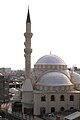
 View of Osmaniye city center |
||||
| Basic data | ||||
|---|---|---|---|---|
| Province (il) : | Osmaniye | |||
| Coordinates : | 37 ° 5 ' N , 36 ° 15' E | |||
| Height : | 129 m | |||
| Residents : | 237,476 (2019) | |||
| Telephone code : | (+90) 328 | |||
| Postal code : | 80,000 | |||
| License plate : | 80 | |||
| Structure and administration (as of 2019) | ||||
| Structure : | 36 Mahalle | |||
| Mayor : | Kadir Kara ( MHP ) | |||
| Website: | ||||
| Osmaniye County | ||||
| Residents : | 268,647 (2019) | |||
| Surface: | 859 km² | |||
| Population density : | 313 inhabitants per km² | |||
| Website (Kaymakam): | ||||


Osmaniye is a Turkish city in the Mediterranean region and has a population of 231,739 (population update end of 2018). It is the provincial capital of the Osmaniye province, newly created in 1996 .
geography
The central district (Merkez) is actually in the south of the province and internally borders on all districts, with the exception of Bahçe and Sumbas . Externally it borders in the south on the districts of Erzin and Dörtyol of the Hatay province and in the east on the district of İslahiye in the province of Gaziantep .
In addition to the district town, there is another municipality (small town, Belediye ): Cevdetiye with 3,263 inhabitants. In addition there are 37 villages ( Köy ) with an average population of 794 inhabitants (the highest average of all districts). Eleven villages have over a thousand inhabitants, Akyar (2,244), Yarpuz (1,859), Çardak (1,795), Dereli (1,744) and Dereobası (1,689 pop .) Are the largest. The population density is the highest in the province and is almost twice the provincial average.
history
Osmaniye was founded in 1866. The foundation served to settle rebel tribes that had risen during the Gâvur Dağı uprising. The name Osmaniye is derived from the Osman house .
After the end of the First World War , the city, like almost the entire southeast of today's Turkey , was occupied by French troops in accordance with the Treaty of Sèvres . This occupation lasted until 1922. During this time, the local population rebelled against the occupation. The city liberated itself from French occupation on January 7, 1922, so several buildings, streets and squares are dedicated to this date.

Ahmet Alkan Cd. in the center of Osmaniye

View of the city of Osmaniye
Merkez Camii


Population development
The following table shows the comparative population level at the end of the year for the province, the central district and the city of Osmaniye as well as the respective share at the higher administrative level. The figures are based on the address-based population register (ADNKS) introduced in 2007.
| year | province | district | city | ||
|---|---|---|---|---|---|
| real | percent | real | percent | real | |
| 2018 | 534.415 | 49.47 | 264,373 | 87.66 | 231,739 |
| 2017 | 527.724 | 49.86 | 263.104 | 88.65 | 233.242 |
| 2016 | 522.175 | 49.72 | 259.614 | 88.36 | 229,406 |
| 2015 | 512,873 | 49.55 | 254.116 | 88.14 | 223,987 |
| 2014 | 506,807 | 49.16 | 249.136 | 87.72 | 218,531 |
| 2013 | 498.981 | 48.94 | 244.195 | 87.24 | 213.045 |
| 2012 | 492.135 | 48.75 | 239.910 | 87.22 | 209.255 |
| 2011 | 485.357 | 48.40 | 234.901 | 86.87 | 204.057 |
| 2010 | 479.221 | 47.94 | 229,744 | 86.55 | 198.836 |
| 2009 | 471,804 | 47.71 | 225,090 | 86.34 | 194,339 |
| 2008 | 464.704 | 47.22 | 219.411 | 86.19 | 189,112 |
| 2007 | 452.880 | 46.43 | 210.285 | 85.82 | 180,477 |
Climate table
| Osmaniye (94 m) | ||||||||||||||||||||||||||||||||||||||||||||||||
|---|---|---|---|---|---|---|---|---|---|---|---|---|---|---|---|---|---|---|---|---|---|---|---|---|---|---|---|---|---|---|---|---|---|---|---|---|---|---|---|---|---|---|---|---|---|---|---|---|
| Climate diagram | ||||||||||||||||||||||||||||||||||||||||||||||||
| ||||||||||||||||||||||||||||||||||||||||||||||||
|
Average monthly temperatures and rainfall for Osmaniye (94 m)
|
||||||||||||||||||||||||||||||||||||||||||||||||||||||||||||||||||||||||||||||||||||||||||||||||||||||||||||||||||||||||||||||||||||||||||||||||||||||
Sports

With the football club Osmaniyespor, the city and the district of Osmaniye have had a football team since the 1940s, which from the 1980s onwards represented the region mainly in the third-highest Turkish league, today's TFF 2nd Lig . The club had its most successful time in the years 1984-1987, in which the club played for two seasons in the second highest Turkish league, today's TFF 1st Lig . In the summer of 2007, the club rose from the fourth-rate and lowest Turkish professional league, the TFF 3rd Lig , and has since played in the regional amateur league, which in turn corresponds to the fifth-highest Turkish league. This club plays its home games in the 7 Ocak Stadyumu (German Satidon of January 7th).
Personalities
- Burcu Ayhan , high jumper
- Devlet Bahçeli , politician
- Ümit broom , musician
- İbrahim Serhat Canbolat , political scientist and writer
- Ümit Kurt , soccer player
Individual evidence
- ↑ a b Türkiye Nüfusu İl ilçe Mahalle Köy Nüfusları , accessed on April 13, 2020
- ↑ Central Dissemination System / Merkezi Dağıtım Sistemi (MEDAS) of the TÜIK , accessed on May 5, 2019
