Palca District (Tacna)
| Palca district | ||
|---|---|---|
 Location of the district in the Tacna region |
||
| Symbols | ||
|
||
| Basic data | ||
| Country | Peru | |
| region | Tacna | |
| province | Tacna | |
| Seat | Palca | |
| surface | 604.6 km² | |
| Residents | 1980 (2017) | |
| density | 3.3 inhabitants per km² | |
| founding | June 8, 1959 | |
| ISO 3166-2 | PE-TAC | |
| politics | ||
| Alcalde District | Héctor Mamani Canavire (2019-2022) |
|
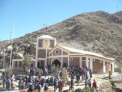
| Parroquia de Causuri | ||
Coordinates: 17 ° 47 ′ S , 69 ° 58 ′ W
The Palca district is located in the Tacna province in the Tacna region in the extreme southwest of Peru . The district has an area of 604.62 km². The 2017 census counted 1,980 inhabitants. In 1993 the population was 1,180, in 2007 1,510. Administrative center of the district is about 40 km northeast of the city Tacna the river Quebrada Palca at an altitude of 2935 m nearby places Palca .
The Palca district extends along the southern flank of the Peruvian Western Cordillera . The district borders Chile in the east . In the south, the district of Palca borders on the district of Tacna , in the west on the districts of Pocollay and Pachía and in the north on the province of Tarata .
Individual evidence
- ↑ a b PERU: Tacna region - provinces and districts . www.citypopulation.de. Retrieved January 18, 2020.
Web links
Commons : Palca District - Collection of images, videos and audio files

