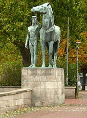
Horse pond (Hanover)
For centuries, the horse pond in Hanover served as a trough for the countless horses in the old town . The location of the ramp leading down to the horse pond in the middle of the Leine is the promenade along the street Am Hohen Ufer below the Begin Tower and the Historical Museum in the Mitte district .
history

Colored postcard no. B 1319 as a lithograph over collotype by the Dresden art printing company Wilhelm Hoffmann AG

After the sovereign of the former principalities of Calenberg and Göttingen , Georg zu Braunschweig-Lüneburg, declared Hanover to be his royal seat in 1636, in the middle of the Thirty Years' War, the old town and the Calenberger Neustadt, which was initially founded for the ducal entourage, were surrounded with a new, joint city fortification for defense purposes . Now the former "dirt wall" lying in front of the city wall in the course of the Hohe Ufer between the two cities on the Leine had become superfluous and was expanded into a representative area in front of the Leineschloss . Along the Leine, from the Begin Tower to the Goethe Bridge (which was built later) , an armory , stables and an open riding arena until 1666 were built . As a watering place for the numerous horses in the now ducal royal seat, the sovereign had the horse pond built in front of the summer bridge to the Leine Island at the level of the horse road in 1684, through which the soldiers and other riders could water the horses entrusted to them directly on the leash.
From 1714, the further expansion of the horse and riding facilities on the Leine initially came to a standstill, as the sovereign of the state, which has meanwhile been elevated to the Electorate of Hanover , Georg Ludwig , left as George I with staff to ascend the throne to London and since then has been the personal union from England ruled between Great Britain and Hanover .
When the number of inhabitants of the royal seat multiplied rapidly during the time of the Kingdom of Hanover in the course of industrialization , the horse pond served primarily as a popular playground for the numerous children of the old town. But until the Second World War , the place was also used to wash the horses and, "as long as the water was still reasonably clean," as a drinking place. In the end, however, the air raids on Hanover reduced around half of the entire city and most of the entire area around the horse pond to rubble and ashes.
The desire to rebuild and remember the cultural heritage led to a redesign of the street Am Hohen Ufer in the wake of the economic miracle of the early years of the Federal Republic of Germany . According to plans by the architect Heinz Wolff , parts of the street were redesigned as a promenade in 1956: the terracing of the banks of the Leine with stone walls made of sandstone was intended to indicate the former city wall, the floor mosaic was composed of rubble stones and its motifs should be based on the structure of Hanover after the Remember wars. At the same time, the ramp to the former horse pond was rebuilt, while the head of the broken summer bridge was designed as a viewing platform.
One year later, in 1957, the sculpture “Man with a Horse” by the sculptor Hermann Scheuertstuhl was put up.
See also
literature
- Franz Rudolf Zankl : Horse pond in the leash between the Hohem Ufer and the island. Photo by Wilhelm Ackermann. 1920. In ders. (Ed.): Hannover Archive . Sheet S 20 .
- Waldemar R. Röhrbein : Horse pond. In: Klaus Mlynek, Waldemar R. Röhrbein (eds.) U. a .: City Lexicon Hanover . From the beginning to the present. Schlütersche, Hannover 2009, ISBN 978-3-89993-662-9 , p. 501.
- Helmut Knocke , Hugo Thielen : On the high bank. In: Hanover. Art and culture lexicon . P. 79 f.
Web links
Individual evidence
- ↑ a b c d e Waldemar R. Röhrbein: Pferdeschwemme (see literature).
- ↑ a b c d e f g Helmut Knocke, Hugo Thielen: Am Hohen Ufer. (see literature).
- ^ Klaus Mlynek : Georg, Duke of Braunschweig-Lüneburg. In: Stadtlexikon Hannover. P. 209.
- ^ Helmut Knocke: City fortifications. In: Stadtlexikon Hannover. P. 585.
- ↑ Helmut Knocke: Goethe Bridge. In: Stadtlexikon Hannover. P. 224.
- ^ Klaus Mlynek: Personal union. In: Stadtlexikon Hannover. P. 498.
- ^ Klaus Mlynek: Population figures . In: Stadtlexikon Hannover. P. 153.
- ^ Klaus Mlynek: Second World War. In: Stadtlexikon Hannover. P. 694 f.
Coordinates: 52 ° 22 ′ 18.6 " N , 9 ° 43 ′ 51.4" E

