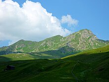
Plate horn
| Plate horn | ||
|---|---|---|
|
Plattenhorn north ridge with Erzhorn (left) |
||
| height | 2554 m above sea level M. | |
| location | Canton of Graubünden ( Switzerland ) | |
| Mountains | Alps | |
| Dominance | 1.25 km → Weisshorn | |
| Notch height | 114 m ↓ ridge between Hörnli and Hörnlihütte (P. 2440) | |
| Coordinates | 766 956 / 183041 | |
|
|
||
| rock | Eastern Alps | |
| Development | Mountain hiking trails and the Plattenhorn chairlift (winter) to the Weng | |
| particularities | former via ferrata | |
The Plattenhorn ( especially earlier also: Plattenhorn ) is 2554 m above sea level. M. high mountain in the Plessur Alps in the canton of Graubünden in Switzerland . It is located in the area of the municipality of Arosa on the border with Tschiertschen-Praden .
Location and description
The Plattenhorn is part of the Central Plessurberge between the Hörnli and the Weisshorn , separated from this by the Carmenna . The three-peaks ridge forms the end of a pronounced dolomite wall from the north . From the southeast steep, characterize schrofendurchsetzte pastures for. The three almost equally high peaks offer an interesting view of the alpine and ski terrain of the Arosa mountain shell as well as the Urdental and the outer Schanfigg .
geology
The Plattenhorn is located in the Arosa shed zone , a geologically extremely complex area. The dolomite fissure, which is clearly visible from the north, is part of the thin Falknis ceiling. This is overlaid towards the Hörnli by the heavily scaled and folded Arosa blanket, which is made up of gneiss , Bündner slate and lava rock and gave the mountain its name through its platy layering . These rocks can be assigned to a deep, primeval ocean basin - the so-called Piedmont Ocean.
Tourist development
The Plattenhorn was a popular destination for ski tourers from an early age, with a challenging downhill variant towards Urder Augstberg-Tschiertschen. In 1966 the Arosa Bergbahnen opened up the western foot of the mountain up to an altitude of around 2300 m above sea level. M. with a drag lift . This cost around half a million Swiss francs and led from "An der Alp" directly over the Carmennaegg into the hollow between the main summit and the north-east summit 2528. There, however, the terminus was very exposed to avalanches and was occasionally crossed by masses of snow. The valley station of the Obersäss chairlift at the Carmennahütte also fell victim to a Plattenhorn avalanche. The four-seater Plattenhorn chairlift, which was built as a replacement in 2002, was therefore given a slightly different route; The mountain station, which was specially built to be safe from avalanches, is now located further south on the foothills of the ridge starting from the main summit at a slightly elevated point.
A via ferrata that started in Carmänna and was built in 2009 via Plattenhorn and Hörnli to the Hörnlihütte had to be closed and dismantled after an accident in spring 2011. The unsecured original route runs south in the lower level and north of the former via ferrata in the upper level.
Routes to the summit
Over the north ridge
- Starting point: Carmenna ( 2367 m )
- Difficulty: T5
- Time required: 30 min. To Pt. 2528, 45 min. To Pt. 2554
- Special: Only original route, via ferrata dismantled
Over the east side
- Starting points: Weisshorn ( 2653 m ), Innerarosa
- Route: On the official hiking trails to the end of the chairlift. From there through one of the two grassy hollows to the ridge.
- Difficulty: T4
- Time required: 2.25 hours from Innerarosa, 1.25 hours from Weisshorn
- Special: The southern grass hollow offers the easiest ascent to the Plattenhorn
Over the southwest ridge

- Starting point: Hörnlihütte ( 2511 m )
- Route: From the foot of the Hörnli on trails along the ridge
- Difficulty: T4
- Time required: 45 min. To Pt. 2554, 1 hour for Pt. 2528
Through the west flank
- Starting point: Tschiertschen ( 1343 m )
- Route: Via Urder Augstberg (Pt. 2222) over the grassy slope to the south summit 2522
- Difficulty: T5
- Time required: 3.5 hours to Pt. 2522, 3.75 hours to Pt. 2554
- Special: Direct access from the north, avoiding the detour to the Hörnlihütte
literature
- Eugen E. Hüsler, Daniel Anker: Die Klettersteige der Schweiz , AT Verlag, Aarau 2010, p. 226.
- Manfred Hunziker: Ringelspitz / Arosa / Rätikon , Alpine Touren / Bündner Alpen , Verlag des SAC 2010, ISBN 978-3-85902-313-0 , p. 37 ff., 296 ff.
- Arosa Bergbahnen AG (Ed.): Bergfahrt - 75 years of mountain railways in Arosa, Weber AG, Thun-Gwatt 2005, ISBN 3-909532-30-6 , pp. 46, 73.
- Hans Danuser : Arosa - as it was then (1996-2003) , vol. 7, self-published by Danuser, Arosa 2004, p. 37.
- Hans Danuser: Arosa - as it was then (1979–1995) , vol. 6, self-published by Danuser, Arosa 2002, p. 56.
- Hans Danuser: Arosa - as it was then (1962–1978) , Vol. 5, self-published by Danuser, Arosa 2001, pp. 56, 103.
Individual evidence
- ↑ Manfred Hunziker: Ringelspitz / Arosa / Rätikon, Alpine Tours / Bündner Alpen , Verlag des SAC 2010, ISBN 978-3-85902-313-0 , p. 38.
Web links
- Max Richter: The Eastern Alpine ceiling arch (PDF file; 1.89 MB)
- Jos Cadisch: Geology of the Swiss Alps (PDF file; 750 kB)


