Camaguey
| Camaguey | |
|---|---|
|
Coordinates: 21 ° 23 ′ N , 77 ° 55 ′ W
Camagüey on the map of Cuba
|
|
| Basic data | |
| Country | Cuba |
| province | Camaguey |
| City foundation | 1514 |
| Residents | 323,309 (2012) |
| City insignia | |
| Detailed data | |
| surface | 1098.58 |
| Population density | 294.3 inhabitants / km 2 |
| height | 95 m |
| Post Code | 70100 |
| prefix | +53 322 |
| Time zone | UTC -5 |
| City patron | Santa María |
| View of Camagüey. | |
Camagüey is the fourth largest city in Cuba with 323,309 inhabitants (2012 census) and the capital of the province of the same name .
history
The city was founded in 1514 as Santa María del Puerto Príncipe by Diego Velázquez de Cuéllar on the north coast near the natural port of Nuevitas, but relocated inland twice by 1528 due to frequent pirate raids . In 1668, however, it was burned down by pirates under Henry Morgan . The city has had its current name since 1923 after an Indian leader.
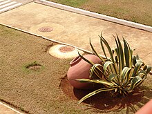
The old town of Camagüey is the largest preserved after that of Havana . The cathedral at Parque Ignacio Agramonte dates from 1748. A special feature are the very large, bulbous clay jugs ( tinajones ) that are still standing next to many entrances or in the inner courtyards . They were used to collect rainwater as the city suffered from a constant lack of water.
In 2008 the historic center of Camagüey was named a UNESCO World Heritage Site .
Personalities
- Gaspar Betancourt Cisneros (1803–1866), railway pioneer
- Gertrudis Gómez de Avellaneda (1814–1873), Spanish writer
- Salvador Cisneros Betancourt (1828–1914), politician and revolutionary, President of the "Republic in Arms"
- Carlos Juan Finlay (1833–1915), doctor and scientist
- Ignacio Agramonte (1841–1873), politician and revolutionary
- Gaspar Agüero y Barreras (1873–1951), composer and pianist
- Manuel Arteaga y Betancourt (1879–1963), Roman Catholic clergyman, Archbishop of Havana and Cardinal
- Nicolás Guillén (1902–1989), poet and writer
- Candita Batista Batista (1916-2016), singer
- Francisco Ricardo Oves Fernández (1928–1990), Roman Catholic clergyman and San Cristóbal de la Habana
- Adalberto Álvarez (* 1948), pianist, composer and arranger
- Juan García Rodríguez (* 1948), Archbishop of Havana and Cardinal
- Wilfredo Pino Estévez (* 1950), Roman Catholic clergyman, Archbishop of Camagüey
- Jorge Luis Prats (* 1956), pianist
- Juan Gabriel Diaz Ruiz (* 1960), Cuban clergyman, Roman Catholic bishop of Ciego de Ávila
- Guillermo Martínez (* 1981), athlete
- Julio César La Cruz (born 1989), boxer
- Yasniel Toledo (* 1989), boxer
- Rose Mary Almanza (born 1992), track and field athlete
traffic
Camagüey has an international airport, Ignacio Agramonte International Airport ( CMW ) ( MUCM ). It is also located on the Carretera Central - the central country road running across Cuba from west to east, on which most of the inner-Cuban motor traffic is handled.
Individual evidence
- ↑ Census 2012 (PDF; 257 kB) , ONE
Web links
- Sights and photos from Camagüey
- Entry on the UNESCO World Heritage Center website ( English and French ).


