
Pusztafalu
| Pusztafalu | |||||
|
|||||
| Basic data | |||||
|---|---|---|---|---|---|
| State : | Hungary | ||||
| Region : | Northern Hungary | ||||
| County : | Borsod-Abaúj-Zemplén | ||||
| Small area until December 31, 2012 : | Sátoraljaújhely | ||||
| District since 1.1.2013 : | Sátoraljaújhely | ||||
| Coordinates : | 48 ° 33 ' N , 21 ° 29' E | ||||
| Height : | 329 m | ||||
| Area : | 7.00 km² | ||||
| Residents : | 200 (Jan. 1, 2011) | ||||
| Population density : | 29 inhabitants per km² | ||||
| Telephone code : | (+36) 47 | ||||
| Postal code : | 3995 | ||||
| KSH kódja: | 17048 | ||||
| Structure and administration (status: 2018) | |||||
| Community type : | local community | ||||
| Mayor : | Viktor Takács (independent) | ||||
| Postal address : | Fő u. 68, 3995 Pusztafalu |
||||
| Website : | |||||
| (Source: A Magyar Köztársaság helységnévkönyve 2011. január 1st at Központi statisztikai hivatal ) | |||||


Pusztafalu is a Hungarian community in the county Sátoraljaújhely in Borsod-Abaúj-Zemplén .
Geographical location
Pusztafalu is located in northern Hungary , 92 kilometers northeast of the Miskolc county seat , a good kilometer from the border with Slovakia , on the small river Perecse-Bükk-patak . Neighboring communities are Filkeháza and Füzér , eight kilometers away, and Füzérkomlós six kilometers away. The nearest town, Sátoraljaújhely, is 26 kilometers southeast of Pusztafalu.
Attractions
- Cemetery with wooden grave steles ( Kopjafás temető )
- Local history museum ( Falumúzeum )
- Nature trail ( Kormos-Bába tanösvény )
- Reformed Church, built in 1806, restored in 1925
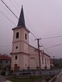
Reformed Church in Pusztafalu
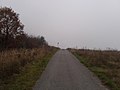
Road to the Slovak border


traffic
Pusztafalu can only be reached via the secondary road No. 37122. The nearest train station is in Sátoraljaújhely.
Web links
- Official website ( Hungarian )
- A pusztafalui református templom (Hungarian)