Black Forest Cross Path Gengenbach – Alpirsbach
| Black Forest Cross Path Gengenbach – Alpirsbach |
|
|---|---|
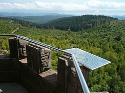
 View from the Moosturm |
|
| Data | |
| length | 51 km |
| location | Germany, Baden-Wuerttemberg , Central Black Forest |
| Supervised by | Black Forest Association |
| Markers | Blue diamond on a yellow background |
| Starting point |
Gengenbach 48 ° 24 '19.2 " N , 8 ° 0' 57.5" E |
| Target point |
Alpirsbach 48 ° 20 ′ 41.3 " N , 8 ° 24 ′ 12.7" E |
| Type | Long-distance hiking trail |
| Height difference | 695 m |
| The highest point | Mooskopf ( 871 m ) |
| Lowest point | Gengenbach ( 176 m ) |
| Level of difficulty | easy / medium |
| season | Spring to autumn |
| Months | March – October |
| Viewpoints | Moss storm |
The Gengenbach – Alpirsbach crossing is a long-distance hiking route through the Middle Black Forest . The 51-kilometer cross-path is maintained and looked after by the Black Forest Association. His signpost is a blue diamond on a yellow background.
Route description
The cross- path starts in Gengenbach in the lower Kinzig valley and runs parallel to the course of the river across the northern Black Forest . The valleys of the Nordrach , Wolf and Kleine Kinzig are crossed on the three stages . In addition, the Querweg crosses the three major long-distance hiking trails of the Black Forest Association Westweg , Mittelweg and Ostweg . At the end point in Alpirsbach , the Kinzig valley is reached again. The ascent and descent are mostly on hiking trails; flat sections (especially on the second stage) mostly follow gravel forest roads.
Day tours / stages
First stage: Gengenbach - Nordrach (Moosmatt)
Overview
- Distance: 16 km
- Walking time: around 4 hours
| Place / sight | Distance (km) |
Height (m above sea level ) |
Further information |
|---|---|---|---|
| Gengenbach | 0 | 176 | Cross path begins at the upper gate |
| Schwandeck | 3.5 | 450 | Wooden pavilion |
| Moss head | 6.5 | 871 | About 200 meters away from the cross path junction with the Kandelhöhenweg |
| Sun house | 4.5 | 560 | Unmanaged hiking home of the Black Forest Association |
| Nordrach / Moosmatt | 1.5 | 380 | Historic coal pile crossing the Nordrach |
Directions
The starting point is the upper gate of Gengenbach. The path continues for about a kilometer, together with the Ortenau Wine Trail, ascending through the village. After the first ascent, the path runs for several kilometers over the ridge (often on hiking trails) and then climbs again steeply to the saddle between Mooskopf and Siedigkopf. The observation tower on the Mooskopf (about 200 meters away from the path) offers a panoramic view; A Lothard monument made of three silver fir trunks was erected on the Siedigkopf (about 400 meters away). Immediately on the way there is a Grimmelshausen monument . From here, the path leads mainly on forest paths initially steeply downwards and before the last descent into the Nordrachtal runs across to the (unmanaged) Sonnenhaus hiking home. The Nordrach is reached at Moosmatt. Here is a restored coal kiln that was still in operation after 1945.
Second stage: Nordrach (Moosmatt) - Schapbach
Overview
- Distance: 20 km
- Walking time: around 5 hours
| Place / sight | Distance (km) |
Height (m above sea level) |
Further information |
|---|---|---|---|
| Nordrach / Moosmatt | 0 | 380 | |
| Rautschhütte | 1.5 | 564 | Forest hut |
| Rosbedunnen | 1.5 | 712 | Saddle between rubbing head and pocket head |
| Heidenkirche | 1.0 | 750 | Sea of rocks |
| Lochbergwasen | 1.5 | 656 | Crossing with the national road 94 |
| Littweger Höhe | 6.5 | 843 | Refuge crossing with the Westweg |
| Hansjakobstein | 4.5 | 700 | Memorial stone for Heinrich Hansjakob crossing with the Kleiner Hansjakobweg |
| Schapbach | 3.5 | 350 | church |
Directions
The ascent from the Nordrachtal is steep to the Rautschhütte on a hiking trail. From there the path continues uphill on a forest path and reaches the Felsenmeer Heidenkirche via the Rosbedunnen saddle. After a short downhill section, the path runs along the slope to Lochbergwasen between Harmersbach and the Renchtal . From here the path runs almost flat over the ridge above the Zuwalder Valley and reaches the Westweg at the Littweger Höhe. Over the Hansjakobstein, the path initially slopes gently, then steeply to the valley of the Wolf , which is reached shortly before Schapbach.
Third stage: Schapbach - Alpirsbach
Overview
- Distance: 15 km
- Walking time: around 4 hours
| Place / sight | Distance (km) |
Height (m above sea level) |
Further information |
|---|---|---|---|
| Schapbach | 0 | 350 | |
| The gate | 4.5 | 705 | Saddle at the Bocksecken intersection with Mittelweg |
| Emilshütte | 1.0 | 745 | Refuge |
| Wittichen | 2.5 | 430 | Former Wittichen monastery |
| Vortal | 1.5 | 412 | Crossing the Kleine Kinzig |
| Saddle bed | 1.5 | 615 | About 500 meters detour to the grill hut “Staufenkopf” ( 683 m ) with a view of the Kinzig valley |
| Alpirsbach | 3.5 | 435 |
Monastery crossing with the Ostweg |
Directions
The Wolftal is left on a steep climb. You reach the saddle "Das Tor" via a forest path. From here to the Emilshütte there is a common route across the Bocksecken with the Mittelweg on a hiking trail. The descent into the valley of the Kleine Kinzig past the former Wittichen monastery takes place on a forest path. The Kleine Kinzig is crossed in Vortal. The following ascent to the saddle is very steep. For the last few kilometers, the path leads above the Kinzig to Alpirsbach.
Web links
Black Forest hiking service : Web application of the Black Forest Association to visualize the Black Forest hiking trails in Google Maps with various overlays (route network, signposts, accommodations, ...)


