Różanka (Międzylesie)
| Różanka | ||
|---|---|---|

|
|
|
| Basic data | ||
| State : | Poland | |
| Voivodeship : | Lower Silesia | |
| Powiat : | Kłodzko | |
| Gmina : | Międzylesie | |
| Geographic location : | 50 ° 11 ' N , 16 ° 38' E | |
| Height : | 450 m npm | |
| Residents : | 380 | |
| Telephone code : | (+48) 74 | |
| License plate : | DKL | |
| Economy and Transport | ||
| Street : | Ext. 389 Międzylesie - Poniatów | |
| Next international airport : | Wroclaw | |
Różanka (German Rosenthal ) is a village in the powiat Kłodzki in the Lower Silesian Voivodeship in Poland. It belongs to the urban and rural community of Międzylesie ( Mittelwalde ).
geography
Różanka is six kilometers northwest of Międzylesie on the edge of the Habelschwerdter Mountains . Neighboring towns are Długopole Górne ( Oberlangenau ) in the north, Domaszków ( Ebersdorf ) and Roztoki ( Schönfeld ) in the northeast, Nagodzice ( Herzogswalde ) and Międzylesie in the southeast and Gniewoszów ( Seitendorf ) in the northwest, where the ruins of Szczerba Castle ( Schnellenstein Castle ) are located. is located.
history
Rosenthal was laid out as a row village and was first mentioned in 1358. It probably belonged to Schnallenstein Castle and after its destruction by the Hussites in 1428 it fell back to the Bohemian rulers as a settled fief . As a chamber village , it was acquired in 1684 by the governor of Glatz, Michael Wenzel von Althann . It then developed into the main town of the Schnallenstein rule , which is why it was also known as the “Rosenthal rule”. After the First Silesian War in 1742 and finally with the Peace of Hubertusburg in 1763, it came to Prussia . After the Rosenthaler Freirichtergut was also acquired by the heir of the Schnallenstein lord in 1796, the whole of Rosenthal was united under one owner. Evidence for 1804: a parish church, a rectory, a school building, a brewery, 31 farmers and 78 gardeners and cottagers .
In the 18th century Rosenthal was a center of linen weaving, which was promoted by King Friedrich II . After the reorganization of Prussia, Rosenthal belonged to the province of Silesia from 1815 and was initially incorporated into the district of Glatz. In 1818 it was reclassified to the Habelschwerdt district , to which it belonged until 1945. In 1874 the district of Rosenthal was formed, to which the rural communities Freiwalde, Marienthal, Peucker, Rosenthal and Seitendorf belonged. In 1939 there were 851 inhabitants.
As a result of the Second World War , Rosenthal fell with most of Silesia to Poland in 1945 and was renamed Różanka . The German population was expelled . Some of the newly settled residents were displaced from eastern Poland . Because of the border location with what was then Czechoslovakia , numerous houses were left to decay. The number of inhabitants decreased significantly as a result. 1975-1998 Różanka belonged to the Wałbrzych Voivodeship .
Attractions
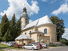
- The Parish Church of the Assumption ( Kościół Wniebowzięcia NMP ) was built from 1591 to 1661. 1755–1756 the church was rebuilt in Baroque style and the tower was built. The frescoes were painted by Joseph Bartsch from Wölfelsdorf in 1756. The altars and the pulpit were created by Michael Klahr the Elder. In 1895 the church received a new high altar, which was designed by the Munich architect Joseph Elsner and delivered from his workshop. He added the sculptures from the former altar by Michael Klahr the Elder to the altar. J. a. The Regensburg painter Ronge created the altarpiece in Nazarene style .
- The brick gate at the entrance to the church was built in the middle of the 18th century and adorned with the figure of the Archangel Michael. The ossuary next to it dates from 1613.
- The rectory from the second half of the 18th century was rebuilt in a neo-Gothic style at the end of the 19th century . The nearby shrines ( Ecce Homo , St. John of Nepomuk , Maria Immaculata ) date from the 18th century.
Personalities
- Erich Homburg (1886–1954), German lieutenant general
- Franz Jaschke (1775–1842), German landscape painter
literature
- Joseph Kögler : The chronicles of the county Glatz . Revised by Dieter Pohl . Vol. 4, ISBN 3-927830-18-6 , pp. 117-126.
- Dehio Handbook of Art Monuments in Poland, Silesia , Munich, Berlin 2005, ISBN 3-422-03109-X , p. 808.
- Peter Güttler: The Glatzer Land . Verlag Aktion Ost-West eV, ISBN 3-928508-03-2 , pp. 94-95.

