
Rodersdorf
| Rodersdorf | |
|---|---|
 |
|
| State : |
|
| Canton : |
|
| District : | Dorneck |
| BFS no. : | 2479 |
| Postal code : | 4118 |
| Coordinates : | 601382 / 258866 |
| Height : | 391 m above sea level M. |
| Height range : | 351–571 m above sea level M. |
| Area : | 5.35 km² |
| Residents: | 1310 (December 31, 2018) |
| Population density : | 245 inhabitants per km² |
| Website: | www.rodersdorf.ch |
 Rodersdorf |
|
| Location of the municipality | |
  |
|
Rodersdorf is a municipality in the Dorneck district in the canton of Solothurn in Switzerland .
geography

Rodersdorf is located in northwestern Switzerland , right on the border with France . The municipal area protrudes noticeably far into the French national territory ( Alsace ): 88 percent of the municipal border is also the Swiss national border. The village is also located with a few other villages in an exclave of the canton of Solothurn , which is enclosed on the Swiss side by the canton of Basel-Landschaft . Because Rodersdorf is located directly on a hill at the northern foot of the Jura , the tram line to Rodersdorf had to go through France (see traffic). In 2014, 14% of the municipal area was in settlements, 31% in forests and woodlands, 54% in agriculture and a little less than 1% in unproductive land.
Rodersdorf borders on the French communities of Biederthal , Oltingue , Liebenswiller , Leymen and the Solothurn Metzerlen-Mariastein .
traffic
The tram line 10 of the BLT (Baselland Transport AG) goes to the terminus Rodersdorf. Line 10 has been the second longest tram line in Europe since 1986 , after the Belgian Kusttram . Since it travels a few kilometers through France for geographic reasons and serves the Leymen train station there, it is considered the longest international tram line. The BLT previously operated the suburban railway as line 17. Since the railway line is now used by trams, a turning loop had to be built at the terminus. Germany, to which Alsace belonged at the time, approved the construction of a meter-gauge railway line, the Basel – Rodersdorf line , in 1910 only on the condition that a station was also built in Leymen. The shortest route through France is also by car, the route via Metzerlen is a detour.
school
There is a primary school and a kindergarten in Rodersdorf . Primary school accompanies the schoolchildren through their first 6 years of school, after which they come to the Leimental Upper School Center (OZL) in Bättwil, where they then go to school with other children from Leimental communities. The OZL can be reached quickly by bus and tram; the children are provided with an annual subscription by the respective municipalities. Thanks to an agreement with the city of Basel , after completing their 9th year of school at OZ-Leimental , children can switch to the Basel grammar schools in order to complete their Matura .
With the inter-cantonal agreement on harmonizing compulsory schooling, Harmos , primary school now lasts 6 years.
history
Over two dozen stone axes in the regional collections attest that people were in the area as early as the Neolithic . On the occasion of the construction of the gas pipeline in 2000, ceramics from the Middle Bronze Age were found over a stretch of approximately one hundred and eighty meters . A cremation grave in today's settlement area dates from the transition from the Bronze Age to the Iron Age .
In the past few years, the manor house of a Roman manor was discovered in the village center and partially excavated. At the same time, traces of a Roman blacksmith's forge with over a ton of forge slag and the foundations of a Gallo-Roman temple were found below the present-day settlement. The traces of a Roman watermill were found below the forge, the third on Swiss soil. Litter finds throughout the settlement area suggest a larger complex.
In the area of the Gallo-Roman temple there was an early medieval cemetery. Over sixty graves have been archaeologically examined. They date from the 6th and 7th centuries and the majority of them showed additions. The excavations have not yet been evaluated. Another early medieval cemetery was found in the foundations of the Roman mansion.
In the High Middle Ages, around 1150, a noble family from Biederthan (from Biederthal , in Upper Alsace) appears. However, his property was transferred to the Habsburgs by Emperor Barbarossa in 1168 . Whether the sex died out or whether the Biederthan people did not want to accept the transition from the loosely governed stronghold to the more tightly organized empire? In any case, a knight family von Biederthan is mentioned in 1197 together with their relatives knights von Ratolsdorf (Rodersdorf). In the next generation, the branch line of Rapperch - later Rotberg - branched off from the Ratolsdorfern.
The Ratolsdorfer were found in the Habsburg service in Alsace, including as governors, until they died out around 1440. The Rotbergers followed in their footsteps as village lords via Rodersdorf. In the 15th century the area suffered from tensions between the Austrian-minded knighthood, the cities and the confederates ( Mörsberger ). The remains of the village of Biedersdorf / Bisisdorf, which had been abandoned around 1440 in this turmoil, were discovered on the occasion of the gas pipeline construction in 2000 in what is now Rodersdorf's municipality. The Rotbergers then sold the Reichslehen Rotberg and their Habsburg-dependent Allod Rodersdorf including the Leihauser Hof to the Solothurners in 1515. Rodersdorf had become Solothurn and at the same time federal.


About the church conditions: Rodersdorf formed a parish with the communities of Biederthal , Liebenswiller and Burg . Biederthal was Habsburg, as was Liebenswiller, but, like the prince-bishop's castle, was subordinate to the Lords of Wessenberg. After the Thirty Years War , Biederthal and Liebenswiller fell to France in 1648. From then on, the Rodersdorfer from Solothurn, the French Bidertahler and Liebenswiller and the episcopal Burgthaler gathered in the parish church of Rodersdorf.
In contrast to the other villages in the parish, Rodersdorf was harassed and damaged by warring parties during the Thirty Years' War, but got away relatively unscathed. In 1643 the parsonage, which still exists today, was rebuilt, from 1670 to 1680 the church was given its present size.
The French Revolution brought the end of the parish. The whole Upper Rhine was separated from the diocese of Basel and defeated in Strasbourg , and consequently in 1804 the foreign parishes were also separated from Rodersdorf. In general, the Solothurn leimental was also claimed politically by the French. However, the separation was never carried out and it was possible to save the enclave, which had been completely enclosed by France since 1792, over to the new order, where Rodersdorf, with the subsequent liberal upheaval, became the semi-autonomous community today.
In 2002 Rodersdorf was the first municipality in Switzerland to introduce e-government , and in 2003 the official Rodersdorf website won a media award for the best municipality website in Switzerland.
Attractions
photos

Church area

Rectory

Former Gasthof Engel

Local government

Biederthalstrasse

BLT terminus
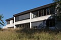
Primary school building

gym


Personalities
- Josef Bernhard Altermatt (born March 27, 1722 in Rodersdorf, † March 28, 1811 in Rodersdorf), builder of the Altermatthof in Rodersdorf
- Imma Grolimund (1872–1944), writer, born in Rodersdorf
coat of arms
- Split by red and white with two turned away, scaled, curved fish in alternating colors. The coat of arms is based on that of the Counts of Pfirt
politics
The parties CVP, SP and FDP each have a local section in Rodersdorf. The SVP and the group KWR (Klimawandel Rodersdorf) are no longer politically active.
literature
- Gottlieb Loertscher: The art monuments of the canton of Solothurn, Volume III: The districts of Thal, Thierstein, Dorneck. (= Art Monuments of Switzerland. Volume 38). Edited by the Society for Swiss Art History GSK. Bern 1957, DNB 750089342 .
Web links
- Official website of the Rodersdorf community
- Lukas Schenker: Rodersdorf. In: Historical Lexicon of Switzerland .
Individual evidence
- ↑ Permanent and non-permanent resident population by year, canton, district, municipality, population type and gender (permanent resident population). In: bfs. admin.ch . Federal Statistical Office (FSO), August 31, 2019, accessed on December 22, 2019 .
- ↑ Urs Altermatt : Josef Bernhard Altermatt. In: Historical Lexicon of Switzerland .
- ^ Rodersdorf - CVP Dorneck-Thierstein. Retrieved September 11, 2017 .