Raneck
| Raneck ( Scattered Houses ) | ||
|---|---|---|
|
|
||
| Basic data | ||
| Pole. District , state | Scheibbs (SB), Lower Austria | |
| Judicial district | Scheibbs | |
| Pole. local community | Gaming ( KG Lackenhof ) | |
| Locality | Lackenhof | |
| Coordinates | 47 ° 52 '47 " N , 15 ° 11' 11" E | |
| height | 954 m above sea level A. | |
| Building status | 5 (2012) | |
| Postcodes | 3295 Lackenhof | |
| Statistical identification | ||
| Counting district / district | Gaming South (32001 003) | |
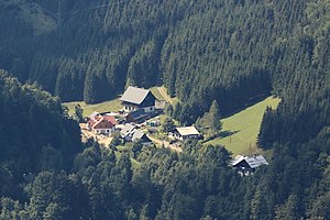
 View from the Rauen Kamm to the hamlet of Raneck |
||
| Source: STAT : index of places ; BEV : GEONAM ; NÖGIS | ||
Raneck is a small town on the Ötscher and belongs to the municipality of Gaming in the Scheibbs district , Lower Austria .
geography
The 5 houses are located at an altitude of 950 m , on the north flank of the Ötscher massif, on the pass that connects the valley of the Ois (Ybbs) with that of the Erlauf .
- Neighboring places
| Stone wall | Nestelberg | |

|
Trübenbach | |
Hiking trails
Long-distance hiking trail 05, which comes up from Lackenhof, leads north via Schönwald - Kerschbaum to the Ötscher stalactite cave , and a path ( no.277 ) leads east into the Erlauftal near Erlaufboden , to Trübenbach below the Zwölfermauer . To the northwest you reach the Steingrabenkreuz ( 1024 m above sea level , on the Fallmannkogel). There is no direct ascent from Raneck to the Ötscher, the summit of which rises directly to the southeast.
Individual evidence
- 32001 - gaming. Community data, Statistics Austria .

