
Roßkopf (Soodener Bergland)
| Rosskopf | ||
|---|---|---|
.JPG) View over houses from Kammerbach northeast to the Roßkopf |
||
| height | 482.4 m above sea level NHN | |
| location | near Kammerbach ; Werra-Meißner-Kreis , Hessen ( Germany ) | |
| Mountains | Soodener Bergland , Lower Werrabergland | |
| Coordinates | 51 ° 16 '58 " N , 9 ° 55' 7" E | |
|
||
| rock | Greywacke | |
| particularities | Roßkopf observation tower | |

The Roßkopf is 482.4 m above sea level. NHN the highest and also central mountain in the Soodener Bergland . It is located near Kammerbach in the Werra-Meißner district in northeast Hesse ( Germany ).
The summit of the mountain is on its northeastern crest ( 482.4 m ), and the Roßkopf observation tower is on the southwest crest ( 440.2 m ) .
geography
location
The Roßkopf rises in the geo-nature park Frau-Holle-Land (Werratal.Meißner.Kaufunger Wald) in the urban area of Bad Sooden-Allendorf . Its summit is 1.8 km north-north-east of Kammerbach, 2.3 km north-east of Hilgershausen , 3.5 km west-north-west of the core town of Bad Sooden-Allendorf, 2 km west of Ahrenberg and 3 km south-south-west of Oberrieden .
Natural allocation
The Roßkopf belongs to the natural spatial main unit group Osthessisches Bergland (No. 35), in the main unit Unteres Werrabergland ( Unteres Werraland ; 358) and in the subunit Unterwerrasattel (358.0) to the natural area Soodener Bergland (358.02). The landscape drops to the southwest into the natural area of Meißnervorland (358.03).
Flowing waters
The Werra tributary Oberrieder Bach flows west past the Roßkopf and is fed by the Brückenbach , which rises to the southwest of the mountain, and two brooks swelling on the north slope. The Dohrenbach rises on the eastern slope and a little northeast of it the Ahrenbach , both of which flow into the Werra side canal Solgraben .
Protected areas
Parts of the fauna-flora-habitat area Werra- and Wehretal (FFH no. 4825-302; 244.8191 km² ) are located on the forested Roßkopf . The landscape falls to the west into the Riedbachtal landscape protection area ( CDDA no. 555547208; 96.54 ha ).
Roßkopf observation tower
The Roßkopf observation tower ( Roßkopfturm ; ⊙ ) is located on the southwestern crest of the Roßkopf . It was built in 1950 and looked after by the Werra Valley Association. The view is completely unobstructed to the south and extends over Kammerbach and the communities Berkatal and Meißner in good visibility to Heldrastein , the Großer Inselsberg , the Wasserkuppe and the Milseburg . In the south-west, the Hohe Meißner massif dominates . The view to the east and west is severely restricted by trees. To the north, through a lane between the trees, Hanstein Castle and parts of the Thuringian Eichsfeld with the Höheberg can be seen.

Roßkopfturm

Roßkopf observation tower
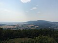
View from the Roßkopfturm over Kammerbach to the Hohe Meißner

_X5H.jpg)
_X5H.jpg)
Others
The Roßkopf is a sandstone knoll that has been broken through by karst . On the transition area to the northeastern Solberg ( 339.8 m ) is the hunting oak , designated as a natural monument , and the Weiberstein rock formation is located on the southern slope of a 467.1 m high southeastern foothill .
Traffic and walking
From Bad Sooden-Allendorf south of the Roßkopf, the state road 3239 leads to Kammerbach. There the L 3301 branches off, which runs southwest of the mountain to Hilgershausen. Between Kammerbach and Hilgershausen, the L 3240 branches off from this road, which leads west of the mountain to Oberrieden.
The European long-distance hiking trail E6 , the Werra-Burgen-Steig and the Roßkopfrundweg as well as the main hiking trail 21 of the Werra Valley Association run over the Roßkopf . Hiking trail R also leads up , which begins at the hiker's parking lot Breite Hecke (at the junction L 3422 from the L 3239). On the south-eastern slope there is a refuge about 300 m east-northeast of the Weiberstein .
Individual evidence
- ↑ a b c Map services of the Federal Agency for Nature Conservation ( information )
- ^ Hans-Jürgen Klink: Geographical land survey: The natural space units on sheet 112 Kassel. Federal Institute for Regional Studies, Bad Godesberg 1969. → Online map (PDF; 6.9 MB)
Web links
- View from the Roßkopfturm (labeling of visual targets can be activated), on panorama-photo.net