Howl
|
Howl
community Föritztal
Coordinates: 50 ° 17 ′ 11 " N , 11 ° 14 ′ 38" E
|
|
|---|---|
| Height : | 324 m above sea level NN |
| Incorporation : | June 30, 1994 |
| Incorporated into: | Neuhaus-Schierschnitz |
| Postal code : | 96524 |
| Area code : | 036764 |
Rotheul is a district of Föritztal in the Sonneberg district in Thuringia .
location
Rotheul is located in the southernmost tip of the corridors around Neuhaus-Schierschnitz and was shaped by its border location, especially between 1945 and 1989. The village can be reached by traffic via the district roads 27 and 36. To the south and west of the village there is a larger deserted district (Einödhöfe) with formerly 36 deserted areas.
history
It was first mentioned in documents in 1323. Slavs laid the village on nutrient-poor sandy soils. Therefore, the village fell into desolation in the 14th century, because water and food were the limiting factors. The monastery in Michelsberg and later the Langheim monastery took over the management of the village and the land. In the 15th century a manor was founded , which Hassenberg and Lindenberg helped to manage.
Attractions
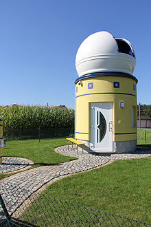
- Rotheul observatory
Web links
- Rotheul on the website of the municipality of Föritztal
Individual evidence
- ^ Wolfgang Kahl : First mention of Thuringian towns and villages. A manual. 5th, improved and considerably enlarged edition. Rockstuhl, Bad Langensalza 2010, ISBN 978-3-86777-202-0 , p. 240.
- ↑ Rotheul on the website of the municipality.Retrieved from the Internet on April 24, 2012
- ↑ https://www.foeritztal.de/portfolio-item/sternwarte-rotheul/


