Rudolphshan
|
Rudolphshan
City of Hünfeld
Coordinates: 50 ° 39 ′ 49 ″ N , 9 ° 41 ′ 53 ″ E
|
|
|---|---|
| Height : | 357 (335-383) m above sea level NHN |
| Residents : | 220 (Dec. 31, 2013) |
| Incorporation : | 1st February 1971 |
| Postal code : | 36088 |
| Area code : | 06652 |
|
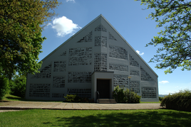
The Catholic branch church of St. Sebastian
|
|
Rudolphshan is a district of Hünfeld in the eastern Hessian district of Fulda . On February 1, 1971, the previously independent municipality was incorporated into the city of Hünfeld as part of the regional reform .
The Rudolphshan district is located on the northern foothills of the Rhön and belongs to the Rhön Biosphere Reserve . The main town of Hünfeld is located southwest of the district. State road 3176 runs south of the district and federal motorway 7 runs to the west .
history
The village was first mentioned in a document in 1422 and belongs to the Fulda monastery . In 1501 the village was deserted again . However, a chapel is mentioned in 1507 . In 1787 it belonged to the abbey of Fulda , Oberamt Burghaun. In 1764 and 1812 it is called the daughter church of Burghaun .
traffic
The local public transport company Fulda ensures local public transport with bus route 73. The next regional train station is Hünfeld. To the ICE network of DB Rudolphshan is on the Fulda station connected. The connection to the German motorway network is ensured via the A 7 with the entrances and exits (90) - Hünfeld / Schlitz near Michelsrombach or via the junction (91) - Fulda-Nord.
literature
- Adrian Seib: Cultural monuments in Hessen. District Fulda II. Burghaun, Eiterfeld, Hünfeld, Nüsttal, Rasdorf. State Office for Monument Preservation Hesse (editor and publisher), Wiesbaden 2011, ISBN 978-3-8062-2607-2 , pp. 376–378.
- Literature on Rudolphshan in the Hessian Bibliography
Web links
- The districts on the city of Hünfeld's website.
- Rudolphshan, District of Fulda. Historical local dictionary for Hessen. In: Landesgeschichtliches Informationssystem Hessen (LAGIS).
Individual evidence
- ↑ Population statistics of the Fulda district , accessed in September 2015.
- ^ Municipal reform: mergers and integration of municipalities from January 20, 1971 . In: The Hessian Minister of the Interior (ed.): State Gazette for the State of Hesse. 1971 No. 6 , p. 248 , para. 25 ( online at the information system of the Hessian state parliament [PDF; 6.2 MB ]).
- ^ Federal Statistical Office (ed.): Historical municipality directory for the Federal Republic of Germany. Name, border and key number changes in municipalities, counties and administrative districts from May 27, 1970 to December 31, 1982 . W. Kohlhammer, Stuttgart and Mainz 1983, ISBN 3-17-003263-1 , p. 399 .
