
Rusko
| coat of arms | map |
|---|---|

|

|
| Basic data | |
| State : |
|
| Landscape : | Varsinais-Suomi |
| Administrative community : | Turku |
| Geographical location | 60 ° 32 ' N , 22 ° 13' E |
| Surface: | 127.91 km² |
| of which land area: | 127.13 km² |
| of which inland waterways: | 0.78 km² |
| Residents : | 6,251 (Dec. 31, 2018) |
| Population density : | 49.2 inhabitants / km² |
| Municipality number : | 704 |
| Language (s) : | Finnish |
| Website : | rusko.fi |
Rusko [ ruskɔ ] is a municipality in the southwest Finland landscape Finland Proper with 6251 inhabitants (December 31, 2018). It belongs to the greater Turku area and is 11 kilometers north of the city center. The community is monolingual in Finnish .
In addition to the parish village of Rusko, the municipality includes the villages of Asola, Hiidenvainio, Hujala, Kankare, Liukola, Lähteenmäki, Munittula, Märttelä, Papumäki and Uttula. The first written mention of Rusko comes from 1337. The church of Rusko was built between 1510 and 1530. A freestanding stack of bells followed in 1741–44 . The Turku airport was formerly part of Rusko, its territory was but meanwhile slammed the city of Turku. At the beginning of 2009, the neighboring municipality of Vahto was incorporated.
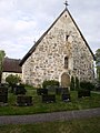
Rusko Church

Vahto Church

Landscape near Vahto


Web links
Individual evidence
- ↑ Maanmittauslaitos (Finnish land surveying office): Suomen pinta-alat kunnittain January 1, 2010 (PDF; 199 kB)
- ↑ Statistical Office Finland: Table 11ra - Key figures on population by region, 1990-2018