
Schmuèr
|
Schmuèr Ual Schmuèr (historical) |
||
_boven_Andiast._(d.j.b.)_04.jpg) Waterfall in front of the Panixersee |
||
| Data | ||
| Water code | CH : 421 | |
| location |
Glarus Alps
|
|
| River system | Rhine | |
| Drain over | Vorderrhein → Rhine → North Sea | |
| Headwaters | at Glatscher as Fluaz 46 ° 51 '34 " N , 9 ° 3' 55" O |
|
| Source height | approx. 2400 m above sea level M. | |
| muzzle | at Rueun in the Vorderrhein coordinates: 46 ° 46 '27 " N , 9 ° 8' 38" E ; CH1903: 730 236 / 181732 46 ° 46 '27 " N , 9 ° 8' 38" O |
|
| Mouth height | 725 m above sea level M. | |
| Height difference | approx. 1675 m | |
| Bottom slope | approx. 14% | |
| length | 12.1 km | |
| Catchment area | 100.57 km² | |
| Discharge at the mouth of A Eo : 100.57 km² |
MQ Mq |
4.16 m³ / s 41.4 l / (s km²) |
| Left tributaries | Aua dil Mer, Ual da Ranasca, Ual da Sontg Antoni | |
| Right tributaries | Flem | |
| Reservoirs flowed through | Panixersee | |
| Communities | Breil / Brigels , Ilanz / Glion | |
The Schmuèr is a 12 kilometer long left tributary of the Vorderrhein in the Swiss canton of Graubünden . It flows through the Val da Pigniu , a side valley of the Surselva , in the municipalities of Breil / Brigels and Ilanz / Glion .
geography
course
The Schmuèr rises from the Glatscher da Fluaz , which extends between Hausstock and Chli Ruchi , at around 2400 m above sea level. M. It flows initially in the area Pastget since Camutschs to southeast through relatively freshly exposed gravel surfaces, which has left the glacier during the retreat. Shortly afterwards, the creek forms an alluvial plain about 200 meters wide due to a terminal moraine blocking the path . A small mountain lake accumulated here until around 2007. Below the Piz Fluaz it breaks through and is at the same time displaced to the eastern flank of the valley by the terminal moraine of the Glatscher da Gavirolas . After a few cascades , it falls about 25 meters into a ravine. The main drain of the Gavirolas glacier flows into this at Alp Cuolm from the right, after two smaller drains from the glacier had already reached the Schmuèr. After further cascades, it reaches the uppermost section of Val da Pigniu after around 4 kilometers, where it is 1447 m above sea level. M. to Panixersee is dammed. Before the dam was built, it flowed through the vast Panixer Alp ( Alp da Pigniu ).
It leaves the reservoir through the Aua dil Mer mountain stream and at the same time forms a small, wooded gorge. Another important tributary flows into this from the left with the Ual da Ranasca , before the gorge opens again at Cuolms . The river now flows through a narrow valley in which it is always accompanied on both sides by a forest edge. At the village of Pigniu , which lies on a slope above the river, more cascades follow. Shortly afterwards it forms a larger gorge near Prau Scharun , in which it has exposed Glarner Verrucanogestein . This opens again just a little below Andiast at the foot of a moraine. Here the longer and more watery Flem joins from the right . The moraine forces the Schmuèr to the east and is severely cut by the river. Below Jörgenberg Castle , it breaks through the moraine and, after a few brook barriers, reaches the Surselva in a wood near Rueun .
At the same time it takes up the Ual da Sontg Antoni from the left and crosses under Hauptstrasse 19 and the Oberland line of the Rhaetian Railway . Finally the Schmuèr flows out at 862 m above sea level. M. from the left into the Vorderrhein.
Catchment area
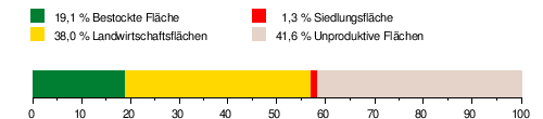
The catchment area of the Schmuèr extends over an area of 100.57 square kilometers. It consists of 41.6% unproductive area, 38% agricultural area, 19.1% wooded area and 1.3% settlement area. The highest point is at 3402 m above sea level. M. on the eastern slope of the Bifertenstock , the average height is 2013.5 m above sea level. M.
In the north is the catchment area of the Linth , in the west that of the Ferrera and in the east that of the Ual da Mulin (Mühlenbach).
Area distribution
Hydrology
At the mouth of the Schmuèr, its modeled mean flow rate (MQ) is 4.16 m³ / s. Its discharge regime type is nivo-glaciaire and its discharge variability is 17.

Web links
Individual evidence
- ↑ a b c Geoserver of the Swiss Federal Administration ( information )
- ↑ a b Topographical catchment areas of Swiss waters: sub-catchment areas 2 km². Retrieved July 20, 2020 .
- ↑ a b Mean discharge and discharge regime type for the Swiss water network. Retrieved July 20, 2020 .
- ↑ "Hidden behind the mean values" - the variability of the discharge regime , p. 7
- ↑ The discharge variability describes the extent of the fluctuations in the mean discharge of individual years around the long-term mean discharge value.