Shoreham (Vermont)
| Shoreham | ||
|---|---|---|
 |
||
| Location in Vermont | ||
|
|
||
| Basic data | ||
| Foundation : | October 8, 1761 | |
| State : | United States | |
| State : | Vermont | |
| County : | Addison County | |
| Coordinates : | 43 ° 54 ′ N , 73 ° 19 ′ W | |
| Time zone : | Eastern ( UTC − 5 / −4 ) | |
| Residents : | 1,265 (as of 2010) | |
| Population density : | 11.2 inhabitants per km 2 | |
| Area : | 120.2 km 2 (about 46 mi 2 ) of which 112.5 km 2 (about 43 mi 2 ) is land |
|
| Height : | 99 m | |
| Postal code : | 05770 | |
| Area code : | +1 802 | |
| FIPS : | 50-65050 | |
| GNIS ID : | 1462209 | |
| Website : | shorehamvt.org | |
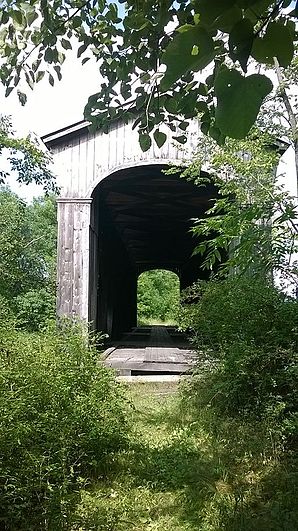
 Disused Covered Railroad Bridge |
||
Shoreham is a town in Addison County of the state of Vermont in the United States with 1265 inhabitants (according to the 2010 census).
geography
Geographical location
The area lies on the southeastern foothills of Lake Champlain . It is mostly flat to hilly and has neither significant elevations nor large watercourses. The main housing estate is in the center of the area at the intersection of the area's two main roads, Vermont Routes 22A and 73.
Neighboring communities
All information as air lines between the official coordinates of the places from the 2010 census.
- North: Bridport , 2 miles
- North East: Cornwall , 6.9 mi
- Southeast: Whiting , 7.1 mi
- South: Orwell , 3.2 mi
- Southwest: Dresden, New York , 12 mi
- West: Putnam, New York , 7.7 mi
- Northwest: Ticonderoga, New York , 16 mi
climate
The mean average temperature in Shoreham ranges from −7.8 ° C (18 ° Fahrenheit ) in January to 21.1 ° C (70 ° Fahrenheit) in July. This means that the place is about 10 degrees cooler compared to the long-term mean of the USA, but relatively temperate compared to the Vermont climate. At more than five and a half meters, the snowfall between October and May is about twice as high as the average snow depth in the USA, the daily sunshine duration is at the lower end of the range of values in the USA, from September to mid-December it is even significantly lower.
history
The city was proclaimed for settlement on October 8, 1761 at the instigation of Ephraim Doolittle , a colonel in the United States Army, by Governor Benning Wentworth as part of his New Hampshire Grants and sold to him and 60 interested parties. The Colonel had discovered the site during the construction of a boardwalk at the time of the French and Indian War in 1759 and, because of its fertility, found it to be good land for a settlement.
The reclamation was actively pursued from 1766; the first settlers came from Worcester County , Massachusetts . Other traditional places of origin of the settlers are Goshen in Connecticut and other places in Massachusetts: Shrewsbury , Sheffield , Lenox and others.
As in the surrounding settlements, the threats of the War of Independence resulted in severe setbacks; the settlement was temporarily abandoned and the settlers evacuated. Only after the end of the war against the British was there permanent settlement. The constituent city assembly took place on November 20, 1786.
An existing military road between the fort at Chimney Point in Addison and Fort 4 in Charleston , which had already been laid out in 1759, formed the starting point for a separate road network, which was built from 1781. In 1786 the town's first bridge was built. The first school lessons were given from 1785 or 1786, the first school building was established in 1788.
From 1799 a ferry crossed the foothills of Lake Champlain at Larabee's Point and enabled the trade and use of mills in New York . The ferry still exists today. At times it was the only steam-powered ferry in Vermont.
In the war against the British in 1813, thirty men of the community served on the side of the American armed forces; Wounded or even killed are not named.
The Leicester – Ticonderoga railway line , which had opened in 1871, opened up new markets for the town's agriculture industry, but did not lead to the industrialization of the area; only the sheep breeding and wool production that had prevailed until then was gradually converted to the dairy farming that is predominant today. The closure of the line in 1951 did not lead to any significant changes in the economic structure; the village was and is still agricultural today.
Religions
Two religious communities are active in the village: a Roman Catholic , St. Genevieve, and a community of the United Church of Christ .
Population development
| Census Results - Town of Shoreham, Vermont | ||||||||||
|---|---|---|---|---|---|---|---|---|---|---|
| year | 1700 | 1710 | 1720 | 1730 | 1740 | 1750 | 1760 | 1770 | 1780 | 1790 |
| Residents | 721 | |||||||||
| year | 1800 | 1810 | 1820 | 1830 | 1840 | 1850 | 1860 | 1870 | 1880 | 1890 |
| Residents | 1447 | 2033 | 1881 | 2137 | 1675 | 1601 | 1382 | 1225 | 1354 | 1240 |
| year | 1900 | 1910 | 1920 | 1930 | 1940 | 1950 | 1960 | 1970 | 1980 | 1990 |
| Residents | 1193 | 1098 | 925 | 948 | 865 | 829 | 786 | 790 | 972 | 1115 |
| year | 2000 | 2010 | 2020 | 2030 | 2040 | 2050 | 2060 | 2070 | 2080 | 2090 |
| Residents | 1222 | 1265 | ||||||||
Economy and Infrastructure
traffic
The main housing estate is in the center of the area at the intersection of the area's two main roads, Vermont Routes 22A and 73 . The community is opposite Fort Ticonderoga and is connected to the city of Ticonderoga by one of the oldest continuously operating ferry routes, the ferry named after Fort Ti .
Public facilities
There are no public facilities in Shoreham other than normal local government and elementary school. The closest hospital is the Porter Medial Center in Middlebury.
education
Shoreham is part of the Addison Central School District with Bridport, Cornwall, Middlebury, Ripton, Salisbury and Weybridge.
In Shoreham there is a six-class elementary school, the Shoreham Elementary School . For secondary schools, students rely on trips to surrounding communities, particularly Middlebury .
The Platt Memorial Library was initially established as the Shoreham Free Public Library in 1823 and was initially located in a small room in the Meeting House in Shoreham. A new building was erected in 1906, it was a gift from Dr. Mary Mixer Platt, in memory of her husband Dr. William Platt, the town's long-time doctor.
Personalities
sons and daughters of the town
- Silas H. Jennison (1791–1849), governor of Vermont
- Joel Turrill (1794-1859), member of the US House of Representatives
- John Smith Chipman (1800–1869), Member of the US House of Representatives
- Augustus C. Hand (1803–1878), Member of the US House of Representatives
- Ansel Briggs (1806–1881), 1st Governor of Iowa
- Columbus Delano (1809-1896), US Secretary of the Interior
- Selucius Garfielde (1822–1881), member of the US House of Representatives
- Levi P. Morton (1824–1920), 22nd Vice President of the United States
- Ebenezer J. Ormsbee (1834–1924), governor of Vermont
literature
- Zadock Thompson: History of Vermont, natural, civil and statistical, in three parts . 3rd volume. Chauncey Goodrich, Burlington 1842, p. 162 ( limited preview in Google Book search).
- Leonard Deming: Catalog of the Principal Officers of Vermont . Middlebury 1851 ( limited preview in Google Book search).
- Abby Maria Hemenway: The Vermont historical Gazetteer . Burlington 1867, p. 93 ff .
-
History of Shoreham to circa 1880
Copy from an 1886 History of Addison County, edited by HP Smith. Middlebury College website. ( Memento from August 16, 2014 in the Internet Archive )
Web links
- Homepage of the municipality (English)
- Profile of the municipality on the official portal www.Vermont.gov
- Entry on VirtualVermont (English) ( Memento from May 13, 2016 in the Internet Archive )
- The home Shoreham Historical Society (English)
Individual evidence
- ↑ Shoreham in the Geographic Names Information System of the United States Geological Survey , accessed October 1, 2014
- ↑ Population data from the 2010 US Census in the American Factfinder
- ↑ Coordinates of the locations of the Census Authority 2010
- ↑ Climate data at www.City-Data.com (English)
- ↑ Population 1790–2010 according to the census results
- ^ Addison Central School District / Homepage. In: acsdvt.org. Retrieved July 27, 2017 (English).
- ^ Platt Memorial Library. In: plattlib.org. Archived from the original on September 5, 2018 ; accessed on September 23, 2018 (English).


