Sondorillo District
| Sondorillo District | |
|---|---|
 The Sondorillo district is centrally located in the Huancabamba province (marked in red) |
|
| Basic data | |
| Country | Peru |
| region | Piura |
| province | Huancabamba |
| Seat | Sondorillo |
| surface | 226.1 km² |
| Residents | 10,162 (2017) |
| density | 45 inhabitants per km² |
| founding | March 27, 1935 |
| ISO 3166-2 | PE-PIU |
| Website | munisondorillo.gob.pe (Spanish) |
| politics | |
| Alcalde District | Edwin Fidel Galvez García (2019-2022) |
| Political party | Alianza para el Progreso |
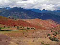
| Soil erosion near Sondorillo | |
Coordinates: 5 ° 20 ′ S , 79 ° 26 ′ W
The Sondorillo district is located in the Huancabamba province of the Piura region in northwestern Peru . The district was established on March 27, 1935. It has an area of 226.09 km². At the 2017 census, 10,162 people lived in the district. In 1993 the population was 9,816, in 2007 10,518. The administrative center is the village of Sondorillo at an altitude of 1888 m with 629 inhabitants (as of 2017). Sondorillo is located 11 km south of the provincial capital Huancabamba .
Geographical location
The Sondorillo district is located in the Peruvian Western Cordillera in the center of the Huancabamba province. The northwestern district boundary runs along the continental divide . The Río Huancabamba flows south along the eastern district boundary. Its tributary Quebrada Sangrin forms the northern district boundary.
The Sondorillo district is bordered on the southwest by the district Huarmaca , on the west by the districts of San Miguel de El Faique and Canchaque , on the north by the district Huancabamba and to the east by the district sondor .
Individual evidence
- ↑ a b Peru: Piura - Provinces & Districts . www.citypopulation.de. Retrieved April 2, 2020.
