Canchaque District
| Canchaque District | ||
|---|---|---|
 The Canchaque district is located in the central west of the Huancabamba Province (marked in red) |
||
| Symbols | ||
|
||
| Basic data | ||
| Country | Peru | |
| region | Piura | |
| province | Huancabamba | |
| Seat | Canchaque | |
| surface | 306.4 km² | |
| Residents | 7317 (2017) | |
| density | 24 inhabitants per km² | |
| founding | September 5, 1904 | |
| ISO 3166-2 | PE-PIU | |
| Website | municanchaque.gob.pe (Spanish) | |
| politics | ||
| Alcalde District | Aldo Erick Álvarez Ocaña (2019-2022) |
|
| Political party | Partido Democracia Directa | |
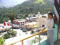
| View of Canchaque | ||
Coordinates: 5 ° 23 ′ S , 79 ° 36 ′ W
The Canchaque district is located in the Huancabamba Province of the Piura region in northwestern Peru . The district was founded on September 5, 1904. It has an area of 306.41 km². At the 2017 census, 7,317 people lived in the district. In 1993 the population was 10,183, in 2007 8,957. The administrative seat is the 1198 m high town of Canchaque with 1,453 inhabitants (as of 2017). Canchaque is located 23 km southwest of the provincial capital Huancabamba .
Geographical location
The Canchaque district is located in the Peruvian Western Cordillera in the central west of the Huancabamba Province. The continental divide runs along the eastern district boundary. The rivers Río Pusmalca and Río Bigote drain the area westward to the Río Piura . The Río Pusmalca runs below Santa Rosa along the southern district boundary to the west.
The Canchaque district borders in the west on the districts Salitral , San Juan de Bigote and Yamango (all in the province of Morropón ), in the far north on the district Pacaipampa ( province Ayabaca ), in the east on the districts Huancabamba and Sondorillo and in the south on the Huarmaca District .
Places in the district
In addition to the main town of Canchaque, there are the following larger towns in the district:
- Coyona (443 inhabitants)
- Los Potreros (241 inhabitants)
- Los Ranchos (511 inhabitants)
- Palambla (369 inhabitants)
- San Francisco (population 246)
- Santa Rosa
Individual evidence
- ↑ a b Peru: Piura - Provinces & Districts . www.citypopulation.de. Retrieved April 2, 2020.

