Berg near Rohrbach
| Berg bei Rohrbach (Former municipality) | ||
|---|---|---|
|
|
||
| Basic data | ||
| Pole. District , state | Rohrbach (RO), Upper Austria | |
| Judicial district | Rohrbach | |
| Coordinates | 48 ° 34 '59 " N , 13 ° 59' 9" E | |
| height | 630 m above sea level A. | |
| Residents of the stat. An H. | 2523 (January 1, 2015) | |
| Building status | 800 (2001 ) | |
| surface | 31.35 km² | |
| Post Code | 4150 | |
| prefix | + 43/7289 | |
| Statistical identification | ||
| Community code | 41344 | |
| Counting district / district | Berg b.Rohrbach center; Berg near Rohrbach area (41344 001, 002) | |
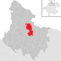
 Location of the former municipality in the Rohrbach district |
||
| Former municipality until April 2015, part of Rohrbach-Berg since May 1, 2015; KG: 47304 Berg, 47305 Frindorf, |
||
Berg bei Rohrbach was a municipality in Upper Austria in the Rohrbach district in the upper Mühlviertel with 2523 inhabitants (as of January 1, 2015). The community was in the judicial district of Rohrbach .
On May 1, 2015, Berg was merged with the neighboring town of Rohrbach to form the new municipality of Rohrbach-Berg , after a referendum held in both municipalities on October 19, 2014 yielded a positive result.
geography
Berg bei Rohrbach is located at an altitude of 631 m in the upper Mühlviertel. The extension of the former municipality was 9.6 km from north to south and 6 km from west to east. The community area was 31.4 km²; 30.6% of the area is forested and 61.8% of the area is used for agriculture.
In 2014, Berg surrounded the district capital of Rohrbach, which had roughly the same population in the north, east and south-east, with almost five times the area.
Districts of the former municipality were:
- Arbesberg
- Berg near Rohrbach
- Fraundorf
- Frindorf
- Fürling
- Gattergaßling
- Greed
- Gintersberg
- Gollner
- Grub
- Hauzenberg
- Hehenberg
- Back ring
- Dog branding
- Katzing
- Keppling
- Krien
- Marching
- Nosslbach
- Newborn
- Perwolfing
- Reith
- Scheiblberg
- Sexling
- Game management
- Steineck
- Wall pubic
history
Originally located in the eastern part of the Principality of Passau , the place has belonged to the Duchy of Austria since the 12th century. Since 1490 it has been assigned to the Principality of Austria ob der Enns . During the Napoleonic Wars , the place was occupied several times.
Around 1850, in the course of the dissolution of the manors, the Berg municipality was founded. Since 1918 the place belongs to the federal state of Upper Austria. After Austria was annexed to the German Reich on March 13, 1938, the place belonged to the "Gau Oberdonau". In 1945 Upper Austria was restored.
Incorporations
In 1938 the then neighboring community of Frindorf was dissolved and most of it was added to the community of Berg.
A union with Rohrbach to "Rohrbach-Berg" was fixed after a referendum held on October 19, 2014 in both communities produced a positive result. The approval of the merger was 89.9% in Rohrbach (turnout approx. 60%) and 58% in Berg (turnout approx. 77%).
politics
The last mayor was Josef Pernsteiner from the ÖVP .
The 2009 municipal council election resulted in the following results, with a turnout of 84.1%:
| Political party | Results 2009 | Results 2003 | Differences | ||||||
|---|---|---|---|---|---|---|---|---|---|
| be right | % | Mand. | be right | % | Mand. | be right | % | Mand. | |
| total | 1,804 | 84.10% | 1,639 | 81.26% | + 165 | + 2.84% p | |||
| Invalid | 60 | 3.33% | 48 | 2.93% | + 12 | + 0.40% p | |||
| Valid | 1,744 | 96.67% | 25th | 1,591 | 97.07% | + 153 | - 0.40% p | ||
| ÖVP | 1,072 | 61.47% | 16 | 952 | 59.84% | 16 | + 120 | + 1.63% p | ± 0 |
| SPÖ | 326 | 18.69% | 5 | 392 | 24.64% | 6th | - 66 | - 5.95% p | - 1 |
| GREEN | 177 | 10.15% | 2 | 162 | 10.18% | 2 | + 15 | - 0.03% p | ± 0 |
| FPÖ | 169 | 9.69% | 2 | 85 | 5.34% | 1 | + 84 | + 4.35% p | + 1 |
The Berger municipal council consisted of 25 members. The former members of the Berg community council were:
- Josef Pernsteiner
- Franz Hötzendorfer
- Friedrich Grims
- Martin Eisschiel
- Leopold Preining
- Bettina Stallinger
- Alois Schürz
The next municipal council and mayoral elections took place in autumn 2015 for the new municipality of Rohrbach-Berg .
Population development
In 1991 the community had 2665 inhabitants according to the census, in 2001 it had 2686 inhabitants.
Culture and sights
- Berg Castle near Rohrbach
- Maria Trost pilgrimage church , built in 1655 by Count Wolf Dietrich von Rödern.
Museums
In Berg there is the Mühlkreisbahn-Museum with the presentation of the history of train stations of the Mühlkreisbahn . The highlight of the exhibition is the Aigen locomotive, which was used on the line until 1910.
Personalities
Sons and daughters of the former parish
- Franz Fuchs (1912–1968), worker and member of the state parliament (ÖVP)
- Alois Hötzendorfer (1918–1995), Federal Councilor and Mayor of Berg
- Johann Hötzendorfer (1873–1947), member of the Reichsrat
- Ulrike Schwarz (* 1958): social worker and member of the state parliament since 2003
partnership
Berg bei Rohrbach had a partnership with the large municipality of Berg bei Neumarkt in the Upper Palatinate since October 1998 .


