Steinfeld (Kall)
|
Steinfeld
Municipality of Kall
Coordinates: 50 ° 30 ′ 11 ″ N , 6 ° 33 ′ 47 ″ E
|
|
|---|---|
| Height : | 480 (-500) m above sea level NHN |
| Residents : | 165 (June 30, 2017) |
| Postal code : | 53925 |
| Area code : | 02441 |
|
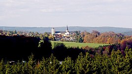
View from the observation tower "Eifel-Blick" near Marmagen on Steinfeld
|
|
Steinfeld is a district of the municipality of Kall in the North Rhine-Westphalian district of Euskirchen with 159 inhabitants.
geography
In the north lies the Schmitzberg.
To the west and east of Steinfeld, the Kuttenbach and Gillesbach flow towards the Urft . The center is the Salvatorian monastery Steinfeld , a former Norbertine abbey from the 11th century. In the monastery is the Basilica Steinfeld , the former abbey church , since the secularization of the parish Steinfeld as Parish Church St. Potentinus serves and 1960 for the papal minor Basilica was charged. The monastery also houses the Hermann-Josef-Kolleg Steinfeld , a Catholic grammar school, and the Steinfeld Academy , which sees itself as a spiritual center.
The Benedictine Abbey of the Visitation of Mary, founded in 1955, is in the immediate vicinity of the Salvatorian monastery .
Also worth seeing are the monastery , the military cemetery and the Hermann-Josef-Brunnen .
The forester's house Steinfeld and the Hallenthaler Mühle are located southeast of the village in the valley of the Gillesbach. It used to be a forced mill of the Steinfeld Abbey for the surrounding villages of Urft , Wahlen and Marmagen .
politics
The incumbent mayor is Frank Vellen.
traffic
Landesstraße 22 runs through the village . The next motorway junction is Nettersheim on federal motorway 1 .
Steinfeld is connected to the Eifel line Cologne - Trier via the Urft (Steinfeld) stop .
See also
Individual evidence
- ↑ residents by district. Municipality of Kall, June 30, 2017, accessed on September 25, 2017 .

