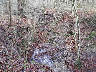
Stigelmattbach
|
Stigelmattbach Butzerütibach, Chlosterholz 2 |
||
|
Stigelmattbach after crossing under the last forest road |
||
| Data | ||
| Water code | CH : 12158 | |
| location | Switzerland | |
| River system | Rhine | |
| Drain over | Reppisch → Limmat → Aare → Rhine → North Sea | |
| source | in the corridor Ibruch 47 ° 21 '59 " N , 8 ° 23' 59" O |
|
| Source height | 606 m above sea level M. | |
| muzzle | at the Reppischtal shooting range in the Reppisch coordinates: 47 ° 22 '27 " N , 8 ° 24' 3" E ; CH1903: 672 665 / 247482 47 ° 22 '27 " N , 8 ° 24' 3" O |
|
| Mouth height | 438 m above sea level M. | |
| Height difference | 168 m | |
| Bottom slope | 17% | |
| length | 1 km | |
| Catchment area | approx. 37 ha | |
| Communities | Rudolfstetten-Friedlisberg , Urdorf , Bergdietikon | |
| Residents in the catchment area | 0 | |
|
The Stigelmattbach flows into the Reppisch in October. The water seeps away beforehand and only reaches the mouth when there is a lot of water |
||
The Stigelmattbach (in Canton Aargau Butzerütibach is called) is a 1 km long left tributary of Reppisch in the communities Rudolfstetten-Friedlisberg , Urdorf and Bergdietikon in the Swiss cantons of Aargau and Zurich . It drains an area of around 0.37 square kilometers on the northern slope of the Holzbirrliberg .
On the maps of the geographic information system of the canton of Aargau , the stream is called Butzerütibach and has a different source stream. The brook, which is called the Stigelmattbach on the geographic information system of the canton of Zurich and on the maps of the Swiss federal administration, is called Chlosterholz 2 in Aargau and is only a tributary of the Butzerütibach there.
geography
course
The stream rises in a field in the Ibruch corridor at 606 m above sea level. M. near the district Friedlisberg . It initially flows northeast, but then turns to the northwest. In the Butzerüti corridor , he takes the Krebsbach from the left and crosses the border to the canton of Zurich. The Stigelmattbach now flows through a ravine in the Underbuechholz corridor , which is parallel to that of the Butzerütibach in the west and that of the Malefizgraben in the east. A little later it crosses over to Aargau soil for around 30 meters, where it takes up the Butzerütibach, which is longer here. It now forms the canton border for around 155 meters and finally flows into the Reppisch at the Reppisch Valley shooting range .
Catchment area
The catchment area of the Stigelmattbach measures approximately 0.37 km², the largest part of which is forested. The highest point in the area is 624 m above sea level. M. in the Boossematt hallway a little east of Friedlisberg . In addition, the lower course of the stream in the canton of Zurich belongs to the Chlosterholz forest reserve .
In the east lies the catchment area of the Malefizgraben , which also flows into the Reppisch.
Tributaries
Direct and indirect tributaries of the Stigelmattbach with length:
- Krebsbach ( left ), 0.1 km
- Ibruchbach 2 ( right ), 0.1 km
- Butzerütibach ( left ), 1.1 km
- Chlosterholz 3 ( left ), 0.1 km
- Chlosterholz 1 ( left ), 0.2 km
flora
In the uppermost section of the stream there is a mixed forest of two-leaf and ash trees, which grows here on waterlogged clay soils. Then it flows through the upper reaches mainly typical woodruff - beech forest with lungwort and forest ziest as well as sedge- brook ash forest with giant horsetail , but also arum- beech mixed forest. In the canton of Zurich it then flows through wood millet and beech forest . The last few meters to the estuary are characterized by a species-poor tooth root beech forest with flaccid sedge and maple ash forest with wild garlic .
See also
Web links
swell
- Geographic information system of the Canton of Aargau
- Geographic information system of the Canton of Zurich
Individual evidence
- ↑ a b Geographic information system of the Canton of Aargau
- ↑ a b c Geoserver of the Swiss Federal Administration ( information )
- ^ Geographic information system of the Canton of Zurich


