Strangriede


Strangriede or Strangriedegraben was the name of a moat near Hanover , which ran in today's Nordstadt district at the level of Engelbosteler Damm and - after a name change - finally flows into the Leine as Stöckener Bach .
history
At the Strangriede
As early as the 14th century, the land in front of the Steintor had passed into the possession of Hanoverian citizens , who had leased land to petty bourgeois since the 16th century . The tenants operated horticulture for purchase and were therefore referred to as so-called " gardeners ". At the beginning of the 18th century, the garden communities north of Hanover had built around 200, and by 1800 - still under the Electorate of Hanover - around 500 houses. Also in 1800 at the latest, these people were already using a dirt road along the Strangriede. Of the garden houses that were inhabited in what is now the northern part of the city, only the garden house at the Judenkirchhof built around 1820 at the time of the Kingdom of Hanover is said to have survived as the last evidence of the originally rural settlement .
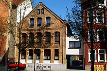
In 1845 the former field path along the moat was officially named An der Strangriede . At this time the area still had a rural, but also already small-town character, as can still be seen from the buildings at Heisenstrasse 24 or Heisenstrasse 31 .
In 1852 the poet Hoffmann von Fallersleben explained the meaning of " -riede " as a Low German word for "Bach" using the example of the Strangriede .
From 1858 the Jewish community had difficulties in their search for a place for a new cemetery , since "[...] only very few parts of the suburban area are completely free of settlements", and finally found the place in the Jewish one opened in 1864 An der Strangriede cemetery . It was similar with the New St. Nikolai Cemetery . Both cemeteries are now protected as garden monuments .
While the area between Engelbosteler Damm and Schneiderberg, which was essentially “over-planned and closed” in the last third of the 19th century, was completely mapped as a “ monument preservation area of interest” due to its historical significance , the entire complex was mapped out in the early days of the German Empire 1892 built complex of the city hospital mid-1980s protected monument reported.
The further course of the Strangriede
Even at the time of the Weimar Republic , the Strangriede ran along the "gardening school" established between 1922 and 1923, which later became the Burg Botanical School Garden and is now the school biology center in the Burg district .
In the distance, the former Strangriede occurs under its present name Stöckener Bach but again only as "[...] Unnatural section" in the district sticks to street level Gretelriede corner Eilersweg from their piping out before around 2.7 km further in the line is flowing.
See also
Literature (selection)
- Michael Tertilt: The North City . Origin and development of a district , city planning office, Hanover 1989
- Sanierungszeitung Nordstadt Hannover , published from 1996 to 2004, Hannover: Madsack Verlagsgesellschaft
- Franziska Scharsky, Michael Römer (Red. And Text): The road connection between An der Strangriede and Halthoffstraße , in this: Redevelopment North City . Final report , City of Hanover, The Lord Mayor, Building Department, Department of Planning and Urban Development, Department of Urban Renewal and Housing, Hanover: LHH, 2007, p. 60f.
- Wolfgang Becker: Sunday chocolates. Industrial wastelands in the redevelopment area Nordstadt , university publication, with a DVD (12.5 minutes), Institute for Architecture and Planning Theory, Hanover 2008
Media coverage
- Uwe Kreuzer: More than a house / Weber massive house creates a home for families in An der Stangriede. In: Hannoversche Allgemeine Zeitung from May 14, 2014; online edition ( Memento from May 15, 2016 in the Internet Archive )
- Red .: Festival in Hanover-Nordstadt now complete / An-der-Strangriede-Fest at the end of August with eleven acts , article from August 18, 2014 on rockszene.de
Web links
Individual evidence
- ↑ a b c d e f Helmut Zimmermann : An der Strangriede , in ders .: The street names of the state capital Hanover. Verlag Hahnsche Buchhandlung, Hannover 1992, ISBN 3-7752-6120-6 , p. 26
- ↑ Helmut Zimmermann: sticks. Farming village and industry , in this: From Anderten to Stöcken ... (= forays into Hanover's history ), Harenberg-Labs, Hanover 1987, ISBN 3-89042-023-0 , pp. 91–94; here: p. 91
- ^ A b c Eva Benz-Rababah : School Biology Center. In: Klaus Mlynek, Waldemar R. Röhrbein (eds.) U. a .: City Lexicon Hanover . From the beginning to the present. Schlütersche, Hannover 2009, ISBN 978-3-89993-662-9 , p. 555; online through google books
- ↑ a b N.N. : Watermark / Stöckener Bach on the page hannover.de , last accessed on May 15, 2016
- ↑ a b Gerd Weiß: Die Gartengemeinden der Nordstadt In: Monument topography Federal Republic of Germany , architectural monuments in Lower Saxony, City of Hanover, Part 2, Volume 10.2 , ed. by Hans-Herbert Möller , Lower Saxony State Administration Office - publications by the Institute for Monument Preservation , Friedr. Vieweg & Sohn, Braunschweig / Wiesbaden 1985, ISBN 3-528-06208-8 , p. 100, as well as location map 2 Nordstadt Hainholz Vahrenwald p. 34f .; as well as Nordstadt in the addendum directory of architectural monuments acc. § 4 ( NDSchG ) (excluding architectural monuments of the archaeological monument preservation ) / Status: July 1, 1985 / City of Hanover. P. 6f.
- ↑ a b Gerd Weiß: The expansion of the north city around the middle of the 19th century. In: Monument topography ... , p. 103ff.
- ^ Hoffmann von Fallersleben: Niederdeutsches Namenbüchlein , Hannover: Karl Rümpler, 1852, p. 59; online at Wikisource
- ↑ Dirk Böttcher , Klaus Mlynek (eds.), Helmut Knocke , Hugo Thielen : Am Lindener Berge 44. In: Hanover. Art and culture lexicon . Handbook and city guide. 4th, updated and expanded edition. zu Klampen, Springe 2007, ISBN 978-3-934920-53-8 , p. 82.
Coordinates: 52 ° 23 ′ 26.7 " N , 9 ° 43 ′ 6" E