
Swist
| Swist | ||
 Swist in Meckenheim |
||
| Data | ||
| Water code | EN : 2742 | |
| location | North Rhine-Westphalia, Rhineland-Palatinate | |
| River system | Rhine | |
| Drain over | Erft → Rhine → North Sea | |
| source | In Kalenborn (at Altenahr) 50 ° 33 '16 " N , 6 ° 59' 9" O |
|
| Source height | approx. 330 m above sea level NHN | |
| muzzle | near Bliesheim in the Erft coordinates: 50 ° 46 ′ 32 " N , 6 ° 49 ′ 56" E 50 ° 46 ′ 32 " N , 6 ° 49 ′ 56" E |
|
| Mouth height | approx. 106 m above sea level NHN | |
| Height difference | approx. 224 m | |
| Bottom slope | approx. 5.1 ‰ | |
| length | 43.7 km | |
| Catchment area | 289.408 km² | |
| Medium-sized cities | Meckenheim | |
| Communities | Grafschaft , Swisttal , Weilerswist | |
The Swist is a stream 43.6 kilometers in length in the Rhineland . It rises on the northern edge of the Eifel and flows between Weilerswist and Bliesheim from the right and south-east into the Rhine inflow Erft . Occasionally the Swist is also called Swistbach , and locals often just call it “the Bach”.
geography

"Swistbachquelle" in Kalenborn

course
The source is at 330 m above sea level. NHN in the northern part of the Eifel in the Ahr Mountains , north of the village of Kalenborn in the community of Altenahr in the Ahrweiler district . The Swist flows with a mean gradient of 5 ‰ first to Vettelhoven ( Grafschaft ) in a northeastern direction and then runs through the Voreifel with a gradient of only 1.3 ‰ . It flows further along the western slope of the Ville in the flange landscape of the Rheinbacher Lößplatte through Meckenheim , Flerzheim , Morenhoven , Heimerzheim and Metternich . The creek gave its name to the municipality of Swisttal and the village of Weilerswist . At 106 m above sea level NN the Swist flows into the Erft between Weilerswist and Bliesheim .
Catchment area
The catchment area lies between that of the Rhine near Bonn or its smaller tributaries such as Hardtbach or Alfterer Bornheimer Bach in the northeast and that of the receiving Erft around Euskirchen close to the west and soon wedges to the north-northwest. It has a rural character and mainly comprises arable land in the open corridor. In addition to meadows and pastures, there is above all a large closed portion of forest around the upper reaches of the stream and its mainly left-hand tributaries. The greater part of the catchment area belongs to North Rhine-Westphalia , in the source area also to Rhineland-Palatinate .
Tributaries
The most important tributary of the Swist is the Jungbach , which flows into the Swist from the left at 15.7 km. It arises in Schweinheim from the confluence of the left Steinbach and right Sürstbach and is called Orbach or Ohrbach up to the last village of Miel am Lauf . With a catchment area of 48.227 km², the 20.5 km long stream contributes about one sixth to that of the Swist.
| Surname |
Stat. in km
|
location | Length in km |
EZG in km² |
Mouth height in m above sea level NHN |
GKZ |
|---|---|---|---|---|---|---|
| Kalenborn Bach / Swistbach | 42.939 | right | 0.6 | 1.018 | 306 | 2742 112 |
| Buchenwaldbach | 42,407 | Left | 1.0 | 1.054 | 296 | 2742 114 |
| Nonnenbach | 39.185 | right | 2.2 | 1,944 | 254 | 2742 12 |
| Bach von Alteheck , also Hahnenbach | 38.103 | right | 1.5 | 1.134 | 243 | 2742 132 |
| NN | 35.251 | Left | 1.1 | 225 | 2742 134 | |
| NN | 32.660 | Left | 1.7 | 219 | 2742 136 | |
| NN | 31,899 | right | 1.4 | 212 | 2742 138 | |
| Essigbach | 29.680 | Left | 5.9 | 7.629 | 182 | 2742 14 |
| Mühlengraben / Spießgraben | 29,334 | right | 1.4 | 4.405 | 178 | 2742 16 |
| Altendorfer Bach | 28,585 | Left | 10.0 | 11,534 | 176 | 2742 2 |
| Ersdorfer Bach | 27.247 | Left | 7.5 | 5.267 | 170 | 2742 32 |
| Morsbach / Wormersdorfer Bach | 24.692 | Left | 6.7 | 12,342 | 161 | 2742 34 |
| NN | 22.675 | right | 3.1 | 155 | 2742 392 | |
| Mühlengraben | 19.088 | right | 2.1 | 146 | 2742 394 | |
| Eulenbach | 19.066 | Left | 12.3 | 23.059 | 146 | 2742 4 |
| Wallbach | 17,589 | Left | 8.9 | 22,600 | 143 | 2742 52 |
| Steinbach / Orbach / Jungbach | 15.717 | Left | 20.5 | 48.227 | 140 | 2742 6 |
| Buschbach | 13,482 | right | 8.2 | 21.965 | 134 | 2742 74 |
| Schiessbach | 12.676 | Left | 13.7 | 16.627 | 132 | 2742 8 |
| Uhlshover Graben | 12,170 | Left | 1.8 | 131 | ||
| Mühlengraben | 12,141 | right | 1.6 | 131 | 2742 912 | |
| Kottengrover ditch | 11,485 | right | 0.7 | 0.736 | 130 | 2742 92 |
| War lover Bach | 9.733 | right | 4.2 | 8.042 | 127 | 2742 94 |
| Müggenhausener Fliess | 3,999 | Left | 5.2 | 11,846 | 113 | 2742 96 |
| Weilerswister Mühlgraben | 0.675 | Left | 2.9 | 107 | 2742 992 |
River history
The Ahr originally ran in what is now the Swist river bed. After the course to the north was blocked by the uplift of the Ahr Mountains, the Ahr looked for its bed in direct connection with the Rhine.
In places there is a reference to the Swist as the longest stream in Europe. This is probably due to the originally very strongly meandering course in the area of the slight slope between Vettelhoven and the mouth. Since the straightening of the Swist at the beginning of the 20th century and at the latest since the canalization of the 1960s, this information is likely to be out of date.
Historic bridges
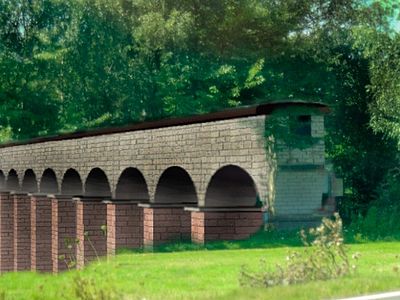
Virtual simulation of the former arch bridge of the Roman aqueduct in the Swistbachaue

Remains of a Prussian bridge over the Swist near Miel

Prussian milestone at the old bridgehead near Miel.


The Roman aqueduct to Cologne crossed the Swist valley between Meckenheim and Rheinbach with an arched bridge 1400 meters long and up to 10 meters high. The archaeologists assume that the bridge must once have had 295 arches with a clear width of 3.56 m. Apart from a low strip of rubble, nothing of the structure has survived.
In Lützermiel , the foundations of a historic bridge have been preserved, on which the Bonn-Schleiden district road from 1823 crossed the Swist; As an archaeological investigation from 1998 showed, a Roman road already crossed the Swist here in Roman times.
Water flow and flooding
The water level of the Swist fluctuates very strongly. The discharge can be between under 0.1 and over 50 m³ / s at the mouth. In 1961 there was a great flood of the Swist. Numerous places were flooded, some houses could only be reached by boats. Flerzheim and especially Heimerzheim were particularly badly affected. Due to the floods, the natural course of the Swist was changed significantly by the Erftverband in the following years . A so-called trapezoidal profile was laid out over long stretches and the stream bordered. As a result, the flow rate increased significantly; several floodplains such as the former “Swistknick” near Dünstekoven were eliminated. In the course of the work, numerous farm roads were laid out along the Swist, which can be used by walkers and cyclists.
In 1984, despite - or perhaps because of - the canalization, there was another flood that was similarly severe as in 1961. In 2009, the Swist again caused severe flooding, but there were only isolated floods.
The high flow velocity and the lack of floodplain areas have proven to be particularly problematic. However, the Steinbachtalsperre can have a positive effect on flood protection . Although the dam was not approved and built for the purpose of flood protection, there is a time delay in the flow of the Steinbach due to the storage capacity of the water. This positive effect lasts until the maximum impoundage reached and any further flow into the dam on the spillway ( overflow drains back).
In times of low precipitation, however, many of the tributaries of the Swist fall dry. This is due, among other things, to the lowering of the groundwater level as a result of the swamp measures for the open- cast lignite mines .

Swist in Metternich

Renaturation
Since the 1990s, efforts have been made to make the Swist more natural again and to increase the water quality. After some preparatory work since 2003, the main part of the measures is to be implemented between 2013 and 2027. At Miel , for example , flood compensation areas, so-called retention areas, are being created and the stone edging of the stream is to be dismantled over long stretches.
Individual evidence
- ↑ a b German basic map 1: 5000
- ↑ a b c d Water directory of the State Office for Nature, Environment and Consumer Protection NRW 2010 (XLS; 4.67 MB) ( Notes )
- ↑ Measurement based on the German base map 1: 5000
- ↑ a b c d GeoExplorer of the Rhineland-Palatinate Water Management Authority ( information )
- ↑ Course of OSM , since no GKZ and neither in table nor in DGK can be found.
- ↑ a b The Swist. (PDF; 4.44 MB) The streams and the groundwater in the Swist area - condition, causes of pollution and measures. Ministry for the Environment and Nature Conservation, Agriculture and Consumer Protection of the State of North Rhine-Westphalia, September 2008, accessed on September 26, 2017 .
- ↑ Jean Joseph Tranchot : Topographical recording of the Rhineland . (1801-1814).
- ^ Klaus Grewe : Atlas of the Roman water pipes to Cologne (= Rhenish excavations. Volume 26). With contributions by Werner Brinker, Günther Garbrecht, Hansgerd Hellenkemper , Heinz-Otto Lamprecht, Horst D. Schulz , Edgar Thofern. Rheinland-Verlag, Cologne 1986, ISBN 3-7927-0868-X , p. 134 ff.
- ↑ Klaus Grewe: The historical Swistübergang at Lützermiel (= Rheinischer Verein für Denkmalpflege und Landschaftsschutz [Hrsg.]: Rheinische Kunststätten. Heft 451). 1st edition. Neusser Druckerei und Verlag GmbH, Neuss 2000, ISBN 3-88094-860-7 .
- ↑ Water level and discharge. (unchecked raw data of the remote stations). In: HOWIS Erft. Erftverband, accessed on September 26, 2017 .
- ↑ Hans-Peter Fuß: I've never seen such a tidal wave. In: General-Anzeiger Bonn. June 1, 2001, accessed January 18, 2014 .
- ↑ Gerda Saxler-Schmidt: upper edge lower lip: Swist flood goes off lightly. In: General-Anzeiger Bonn. March 9, 2009, accessed January 18, 2014 .
- ^ Karl-Heinz Beier: Swist - hydromorphological measures. (PDF; 1.3 MB) Erftverband, April 25, 2008, archived from the original on February 1, 2014 ; Retrieved January 18, 2014 .
- ↑ Natural redesign of the Swist in the Miel retention area. In: EV telegram 2/17. Erftverband, accessed on September 26, 2017 .
- ↑ Bernd Bucher, Karl-Heinz Beier: Renaturation projects in the Erft catchment area in cooperation with the Landesbetrieb Straßen.NRW. (PDF; 5.4 MB) Erftverband, February 12, 2010, archived from the original on February 2, 2014 ; Retrieved January 18, 2014 .
Web links
- Nature reserve "Swistniederung bei Miel" in the specialist information system of the State Office for Nature, Environment and Consumer Protection in North Rhine-Westphalia
- Water profile. (PDF; 215 kB) In: Water Framework Directive - inventory (results reports NRW). Ministry for the Environment and Nature Conservation, Agriculture and Consumer Protection of the State of North Rhine-Westphalia, 2004, archived from the original on February 1, 2014 ; Retrieved January 18, 2014 .
- Explanatory report Swist. Ministry for the Environment and Nature Conservation, Agriculture and Consumer Protection of the State of North Rhine-Westphalia, September 2008 (PDF).