
Symi
|
Municipality of Symi Δήμος Σύμης (Σύμη) |
|||
|---|---|---|---|
|
|||
| Basic data | |||
| State : |
|
||
| Region : | South Aegean | ||
| Regional District : | Rhodes | ||
| Geographic coordinates : | 36 ° 36 ′ N , 27 ° 50 ′ E | ||
| Area : | 65.754 km² | ||
| Residents : | 2,590 (2011) | ||
| Population density : | 39.4 inhabitants / km² | ||
| Community logo: |
|
||
| Seat: | Symi | ||
| LAU-1 code no .: | 6903 | ||
| Districts : | no | ||
| Local self-government : | no | ||
| Website: | www.symi.gr | ||
| Location in the South Aegean region | |||
 |
|||

Symi ( Greek Σύμη [ ˈsimi ] ( f. Sg. ), Turkish Sömbeki ) is a 57.865 km² Greek island in the Dodecanese in the Aegean Sea and belongs to the group of the Southern Sporades . Together with some uninhabited islets, it forms a community ( dimos δήμος) in the South Aegean region.
geography
Symi is located about 9 km west of the Turkish mainland, 23 km north of the island of Rhodes and almost 400 km southeast of Athens .

Symi has a very rugged coastline and a length of 11.5 km with a maximum width of 9 km. It is mountainous and up to 617 m high.
Most of the approximately 2500 inhabitants live in the main town of the same name in the north of the island , beautifully located around the old Kastron , from fishing, the rather sparse agriculture on the rather barren island and the increasingly important tourism. Sponge diving, which dominated just a few decades ago, hardly plays a role anymore.

In addition to various other monasteries and chapels (of which there are 364 on Symi), Panormitis Monastery, located in the south and visited by regular excursion boats from Rhodes, is the most famous on the island. It is dedicated to St. Michael and houses a small museum.
The uninhabited islands of the municipality include Nimos in the north and the islands of Seskli , Chondros, Diavates, Gialesino, Kouloundros and Marmaras.
history
The history of the small island is closely linked to that of the Dodecanese . In the waters off Symi, during the Peloponnesian War in 411 BC, Chr. A naval battle between Athens and Sparta instead.
Up until the end of the 19th century, shipbuilding and sponge diving were historically significant on Symi . The ships built on Symi were so fast that they enjoyed the privilege of the Ottoman sea mail service in the Aegean Sea . Until the end of the 19th century, sponge diving was also in its prime. At that time the island had about 30,000 inhabitants.
From 1912 to 1943 Symi and the entire Dodecanese were occupied by Italians. After Italy left the Second World War , German troops took over the island from October 1943 until it was evacuated in September 1944. British armed forces then landed and monitored the still German-occupied Rhodes from here . On May 8, 1945 Otto Wagener signed the surrender here for the German troops remaining in the south-east Aegean.
The island has belonged to Greece since October 28, 1947 .
Economy and Transport
Apart from tourism, there is no economy of note on the small island.
A connection to the national and international flight network is only available via the nearby islands of Kos and Rhodes . The same applies to the connection to the Greek ferry network. For some years now, Symi has only been approached by local ferries and excursion boats.
The larger towns on the island are connected by paved roads. There is a local bus line that connects the port (Gialos) with the upper part of the town of Symi (Chorio) and the nearest bay, Pedi. In the season there is also a daily bus between the port and the Panormitis monastery. There are a few taxis and providers of rental cars and mopeds. In summer, several taxi boats go to the individual bathing bays.
The development of private transport has developed rapidly over the past thirty years. There was not a single motor vehicle on the island until the late 1970s . All transports were carried out with mules and boats. Even in the early 1990s, there were relatively few motor vehicles. This picture has now changed, numerous cars , motorbikes and trucks shape the streetscape. For the transport of building materials etc. Mules are still used in the upper town due to the narrow streets and many steps.
Drinking water was delivered several times a week by tanker from Rhodes (the state has to raise around € 5 million a year for this) and fed into the local pipeline network, as Symi does not have sufficient freshwater sources. As a result, water is very scarce, especially in the summer season. This is also evident from the very high price of water: a cubic meter of water costs a good five euros (this is almost ten times the price that you pay in Rhodes). This is one of the reasons why there is only one hotel with a swimming pool on the island. In 2010, a seawater desalination plant built for € 5.5 million was put into operation. The power supply is to be provided by a wind turbine . This is the first system of its kind in the world. Initially, the system did not yet deliver the required amount of water, so that the supply by tanker could not be stopped. In May 2011 the desalination plant located on Pedi-Strasse and designed for a volume of 600 m³ per day was partially burnt out. The plant has been in full operation again since June 2012 and there is no need for water deliveries by tanker from Rhodes.
tourism


In the season (May to October), many day tourists come daily with excursion boats from Rhodes to Symi. These are mostly limited to a visit to the Panormitis monastery and the listed harbor (Gialos). There are also day trips from Turkey ( Datça and Bozburun )
In recent years, however, tourists have increasingly used the island for longer stays. A large number of them are regulars. There are numerous small hotels, guest houses and private accommodation available. The island is very popular as a port of call for yachts .
In addition to numerous smaller bays, the island is ideal for long walks or hikes. Day trips to Rhodes, Kos or Turkey (Datça and Bozburun) can be made from the port . There are also two small museums, a nautical museum in the port and a museum about the island's history in Chorio.
In the harbor, numerous souvenir shops try to market the (no longer practiced) sponge diving - but almost all sponges come from other regions of the Mediterranean.
Many Greeks make pilgrimages to the Panormitis Monastery, especially on the Orthodox holidays . There are also very simple, inexpensive overnight accommodations right in the monastery.


View of Symi from the jetty

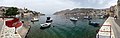
Port Panorama Symi

Port Panorama Symi
Port Panorama Symi

Port Panorama Symi

Panorama view of Symi

Panorama view of Panormitis Monastery

Panorama view from the jetty to the Panormitis monastery

Panorama view of the Panormitis jetty
Web links
Individual evidence
- ↑ Results of the 2011 census, Greek Statistical Office (ΕΛ.ΣΤΑΤ) ( Memento from June 27, 2015 in the Internet Archive ) (Excel document, 2.6 MB)
- ↑ Ελληνική Στατιστική Αρχή [ΕΛΣΤΑΤ] (Ed.): Στατιστική Επετηρίδα της Ελλάδος (Statistical Yearbook of Greece) 2009 & 2010 . Piraeus 2011, p. 47 .
- ↑ Stephanos Psimenos: 341 SYMI / ΣΥΜΗ . 1: 20,000 GIS mapping; GGRS 87; WGS 84. Terrain & Skai, Melissia / Μελίσσια 2009, ISBN 978-960-6845-92-5 (etrrainmaps.gr [accessed June 7, 2012]).
- ^ Symi Top. 9. Περίπατοι. Retrieved May 1, 2014 (Greek).
- ↑ Peter Schenk: Battle for the Aegean. Mittler, Hamburg 2000, ISBN 3-8132-0699-8 , pp. 138f.
- ↑ a b ekathimerini.com
- ↑ Sea water treatment - the salt has to go . FAZnet, March 27, 2009
- ↑ adrianas-symi.blogspot.com