
Thurn
|
Thurn
|
||
|---|---|---|
| coat of arms | Austria map | |
 |
|
|
| Basic data | ||
| Country: | Austria | |
| State : | Tyrol | |
| Political District : | Lienz | |
| License plate : | LZ | |
| Surface: | 12.26 km² | |
| Coordinates : | 46 ° 51 ' N , 12 ° 46' E | |
| Height : | 855 m above sea level A. | |
| Residents : | 619 (January 1, 2020) | |
| Population density : | 50 inhabitants per km² | |
| Postal code : | 9904 | |
| Area code : | 04852 | |
| Community code : | 7 07 31 | |
| NUTS region | AT333 | |
| Address of the municipal administration: |
Dorf 56 9904 Thurn |
|
| Website: | ||
| politics | ||
| Mayor : | Reinhold Kollnig | |
|
Municipal Council : (2016) (11 members) |
||
| Location of Thurn in the Lienz district | ||
  |
||
 Nikolauskirche in Thurn |
||
| Source: Municipal data from Statistics Austria | ||

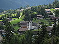
Thurn is a municipality in East Tyrol (district of Lienz, state of Tyrol) and is located on the gently sloping valley floor of the district capital Lienz , about 2 km from the city center with a view of the mountains of the Lienz Dolomites . Thurn has an area of 1,226 ha and 619 inhabitants (as of January 1, 2020). Neighboring communities are Ainet , Gaimberg , Lienz , Nußdorf-Debant and Oberlienz . The community is located in the judicial district of Lienz .
geography
Thurn is located in the north (sunny side) of the Lienz valley floor north of the district capital Lienz at 855 m above sea level. A. The territory extends across the southern slope of Pließriegels, an extension of the Schober group and includes 12.26 square kilometers which Thurn is the third smallest locality of the district Lienz. Thurn borders in the north on Nußdorf-Debant , in the east on Gaimberg , in the south on Lienz and in the west on Oberlienz and Ainet .
Community structure
The municipality of Thurn is congruent with the cadastral municipality of the same name and consists of five districts. If you follow the Thurn state road from Lienz to the north, you will first reach the village of Thurn ( 855 m above sea level ), where 297 people lived in 2011. As the main town in 2001, the village comprises 67 buildings, the town hall, the branch church of St. Nikolaus, the elementary school and the kindergarten as well as the Gasthof Reiter. The hamlet of Lampitze to the east is also included in the village of Thurn. East of the village of Thurn is the Rotte Zauche ( 850 m above sea level ), with 48 buildings in 2001, the second largest district in terms of population in the municipality. In 2011, 198 people lived here. Northeast of Thurn is the Rotte Oberdorf ( 935 m above sea level ) with the Hotel Wahlerhof, in which 96 people lived in 2011. To the north of Thurn and Oberdorf lies the district of Prappernitze ( 997 m above sea level ) which, in addition to the actual Rotte Prappernitze, also includes the scattered settlement Am Berg , the highest single farm Thaler ( 1304 m above sea level ) and the Eggeralm, the Glanzalm Jageralm, the Neue Thurner Alm, the Pettereralm, the Stanisalm and the Weberalm. In 2011, Pappernitze housed 37 residents. In 2001 there were 22 buildings each in Oberdorf and Pappernitze. The smallest and highest district is the holiday home area Zettersfeld , which in 2001 comprised 67 buildings. Seven people lived here in 2011.
topography
The municipality of Thurn extends from around 800 m above sea level. A. in the south to the peaks of the Schobergruppe at around 2900 m above sea level. A. The lowest point of the municipality is located in the area where the Thurner Landesstraße reaches the municipality of Thurn in the south. The highest point in the community is the Schleinitz at 2904 m above sea level. A. Other peaks in the municipality are the Rotgabele ( 2696 m above sea level ) and the Goisele ( 2433 m above sea level ). While the north-western municipal area has a high-alpine character and includes parts of the Neualplseen, Thurn has a share of the Zettersfeld winter sports area in the north-east. The plied bar in between is largely forested, its areas are used as alpine pastures. The only noteworthy flowing water is the Zauchenbach, which rises below the Neue Thurner-Alm and flows through the districts of Oberdorf and Zauche.
climate

As there is no measuring station in Thurn, exact records of the community's climate are missing. However, due to the proximity of the settlements to the weather station in the district capital Lienz, it is comparable with the climatic data measured there. The coldest month of the year in the Lienz basin is January, the highest temperatures are measured in the summer months of July and August. The highest rainfall also falls in the summer months, with the month of October being almost as rainy. Fog rarely occurs in the Lienz Basin, but in winter, due to inversion weather conditions, mighty cold-air lakes form .
history
Thurn is first mentioned in a document in 1308 . It had two castle sites: the older one stood on the "Schlößlbichl", a hilltop in the Großbachtal, and was probably a defensive and residential tower from which the village of Thurn - as the old spelling for tower - gave its name. The more recent complex - Thurn Castle - stood east of the St. Nicholas Church in the Mußhauser courtyard area, a manor whose appearance we know nothing about. A fish pond, which contained the water from the Großbachtal, probably enclosed the castle in a semicircle. The pond wall is still partially preserved. The main building of the Mußhauserhof stands on old walls that could have come from Thurn Castle.
In 1938 Thurn lost its independence and was combined with Gaimberg to form the new Grafendorf community. In 1949 it became a separate municipality again
Various field names still refer to the former Slavic population: Lampitze, Frantsche, Ondelt, Prappernitze.
coat of arms
The Thurner coat of arms was awarded to the municipality on April 19, 1956 by the Tyrolean state government. The blazon reads: “A split shield, in the right, silver field a red tinned tower, in the left, green field two golden ears of corn and at the lower end a closed book with 3 apples of gold.” The representation of the tower points to the eponymous , as a "tower" designated fortification, while the three spheres and the book on a green background as a sign of St. Nicholas indicate his parish patronage. The flanking ears of wheat remind of the former importance of agriculture and the important grain cultivation in the Lienz basin.
population
Population structure
In 2012, 620 people lived in the municipality of Thurn. At the end of 2001, 98.6% of the population were Austrian citizens (Tyrol: 90.6%), until the beginning of 2012 the value had fallen insignificantly to 97.1%. In 2001, 95.0% of the population (Tyrol: 83.4%) professed to be part of the Roman Catholic Church , 13 people had no religious beliefs, six were Protestants.
The average age of the community population in 2001 was far below the national average. 22.1% of the residents of Thurn were younger than 15 years (Tyrol: 18.4%), 61.7% between 15 and 59 years old (Tyrol: 63.0%). The proportion of residents over 59 years of age was 16.2%, slightly below the national average of 18.6%. As a result, the average age of the population of Thurn rose sharply. The proportion of people under the age of 15 fell to 13.9% as of January 1, 2012, while the proportion of people between the ages of 15 and 59 increased to 66.3%. The proportion of people over 59 years of age rose to 19.8%. According to marital status, 48.7% of the residents of Thurn were single, 45.0% married, 4.7% widowed and 1.6% divorced in 2001.
Population development
The population development of the municipality of Thurn in the late 19th century and at the beginning of the 20th century was far below the average population growth of the Lienz district and the state of Tyrol. Rather, Thurn suffered from a process of shrinking until 1923, during which the community lost 18% of its inhabitants between 1869 and 1923 and had the lowest population to date with 243 inhabitants. Only then did this trend reverse and Thurn was able to record population growth again. However, this was below the district average, so that the community needed until 1961 to reach the population of 1869. Only then did growth increase sharply, with Thurn benefiting from a strong birth surplus and subsequently growing faster than the district average. While the birth balance was strongly positive in every decade between 1971 and 2001, the municipality recorded practically no emigration in the 1970s. In the 1980s there was little emigration, in the 1990s there was even an increase in migration. As a result, the municipality was able to record its highest population to date with 642 inhabitants at the end of 2002. Most recently, between 2003 and 2012, in seven out of ten years, the municipality registered a decline in migration that could not be offset by the slight birth surplus. As a result, Thurn lost its inhabitants.

economy
Economically, the place has a focus on tourism and, despite its small size, two accommodation providers. Numerous holiday apartments and private rooms are also available. Thurn was a mining area that supplied rocks containing silver to the brass works in Lienz. It has not been proven whether copper or even gold was mined in the Neualplseen- Schleinitz area. The names of the greetings to "St. Johann ob dem Turm" and the "Holy Trinity" are documented. Several exploratory tunnels that still exist in the Thurner Berg reach only 5 to 10 m into the rock.
Workplaces and employees
The workplace census carried out as part of the census in 2001 revealed 23 workplaces with 64 employees (excluding agriculture) in Thurn, 72% of which were employed. The number of workplaces had risen by 15 companies (plus 188%) compared to 1991, and the number of employees grew by 48 people (300%). The most important branch of the economy in 2001 was the hotel and restaurant sector with seven companies and 23 employees (36% of employees in Thurn). This was followed by the provision of other public and personal services with three workplaces and twelve employees. In addition to the tourism businesses, there are only small trading and commercial businesses in Thurn.
Of the 329 economically active persons living in Thurn in 2010, 3.0% were unemployed. Of the 319 people in employment, 51 were employed in manufacturing (16%), 41 in administration (13%) and 37 in trade (12%). Other important sectors were construction with 34 employees (11%), agriculture and forestry with 30 employees (33%) and education and training with 29 employees (9% each). Of the 315 people in employment in Thurn (not counting people temporarily absent from work), only 58 people were employed in Thurn in 2010. 257 people or 82% of the employed had to commute to work. Of the out-commuters, 58% had their place of work in Lienz, another 14% worked in another municipality in the Lienz district. Another 16% and 12% commuted to North Tyrol or another federal state, none of the residents had to commute abroad. In return, only 26 commuters worked in Thurn in 2010, 88% of whom came from the district.
tourism
Tourism is of great importance for the municipality of Thurn, especially during the winter season. The tourism intensity (overnight stays per inhabitant) in winter 2011 was around 76% higher in winter than the district average, in summer 2012 the municipality still achieved a tourism intensity that was slightly above the district average. In comparison, however, numerous East Tyrolean communities were ahead of Thurn in terms of their number of overnight stays and tourism intensity. Thurn was able to count around 33,000 overnight stays in the 2011/12 tourism year. In the summer half of 2012 Thurn recorded 18,864 overnight stays, in the winter half of 2011/12 14,051 overnight stays. While the municipality was able to achieve a plus of 12% in the summer season compared to the turn of the millennium, it lost 18% of its overnight stays in the winter season.
There is only one hotel in Thurn, but there are also numerous private landlords. The most important tourist attraction is the Zettersfeld winter sports area. The municipality markets itself with the neighboring municipalities of Gaimberg and Oberlienz under the brand "Sonnendörfer", whereby the municipality, like all East Tyrolean municipalities, belongs to the Osttirol Tourism Association. Thurn is organized in the "Lienz Dolomites Holiday Region".
Transport and infrastructure
The municipality of Thurn is accessible from the Thurner Straße (L 321), which leads from Lienz via Patriasdorf to the Filialkirche in Thurn. From the village of Thurn, roads lead to Zauche or Lampitze, an additional connection runs via Oberdorf and Prappernitze to the Zettersfeld. Furthermore, various mountainous forest roads lead from Prappernitze into the alpine pastures of the community. Thurn is connected to the supra-regional public transport network by the Bundschuh Reisen bus line 3 (on behalf of Post AG), which runs from Lienz train station to the Thurn Rottmann stop. The closest connection to the rail network ( Drautalbahn ) is at the Lienz train station .
Thurn has joined forces with the neighboring communities of the Lienz Basin to form the "Abwasserverband Lienzer Talboden", whereby the Abwasserverband operates a sewage treatment plant in Dölsach . In 2002, 98% of the objects producing wastewater in Thurn were connected to the local sewer system or the sewage treatment plant. Only individual objects did not have a sewer connection. The waste that arises in the community is disposed of by the Waste Management Association of East Tyrol (AWVO).
Security and Healthcare
The Thurn volunteer fire brigade was founded in 1928 and maintains a fire station in Oberdorf with a small fire engine and a tank fire engine . The FF Thurn has an active strength of around 30 men. Concerning the health system, Thurn is organized together with Lienz in the social district Lienz-Thurn. In the health district, for example, health services such as elderly and care assistance, home and household help and meals on wheels are organized. The nearest general practitioner and the nearest hospital are in Lienz. The closest police station is also located in the district capital.
politics
Reinhold Kollnig has been the mayor of Thurn since March 2004.
Personalities
- Bernhard Gander (born November 29, 1969), composer
Culture and sights
panorama

Summer in Thurn

Elementary school

Village


Individual evidence
- ↑ Regional studies East Tyrol p. 108
- ↑ State Law and Ordinance Gazette for Tyrol. 1956, 3rd piece. No. 15 "Announcement of the state government of April 19, 1956 on the award of a coat of arms to the municipality of Thurn"
- ↑ a b c d Statistics Austria municipality data from Innervillgraten
- ↑ State Statistics Tyrol (VZ 2001) (PDF; 4.1 MB)
- ^ Office of the Tyrolean provincial government, Tyrolean provincial statistics
- ↑ State of Tyrol, wastewater disposal in the Lienz district (PDF; 7.2 MB)
- ↑ Thurn Volunteer Fire Brigade , accessed on September 10, 2013
- ↑ Social district Lienz-Thurn
Web links
Abfaltersbach | Ainet | Amlach | Anras | Assling | Ausservillgraten | Dölsach | Gaimberg | Heinfels | Hopfgarten in Defereggen | Innervillgraten | Iselsberg-Stronach | Kals am Großglockner | Kartitsch | Lavant | Leisach | Lienz | Matrei i. O. | Nikolsdorf | Nussdorf-Debant | Oberlienz | Obertilliach | Prägraten am Großvenediger | St. Jakob in Defereggen | St. Johann im Walde | St. Veit in Defereggen | Schlaiten | Sillian | Streets | Thurn | Tristach | Untertilliach | Virgen