
Anras
|
Anras
|
||
|---|---|---|
| coat of arms | Austria map | |
 |
|
|
| Basic data | ||
| Country: | Austria | |
| State : | Tyrol | |
| Political District : | Lienz | |
| License plate : | LZ | |
| Surface: | 62.05 km² | |
| Coordinates : | 46 ° 46 ' N , 12 ° 33' E | |
| Height : | 1261 m above sea level A. | |
| Residents : | 1,232 (January 1, 2020) | |
| Postal code : | 9912 | |
| Area code : | 04846 | |
| Community code : | 7 07 04 | |
| NUTS region | AT333 | |
| Address of the municipal administration: |
Village 33 9912 Anras |
|
| Website: | ||
| politics | ||
| Mayor : | Johann Waldauf (Anraser home list) | |
|
Municipal Council : (2016) (13 members) |
||
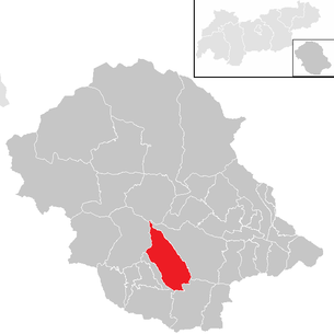
| Location of Anras in the Lienz district | ||
  |
||
| Source: Municipal data from Statistics Austria | ||

Anras is a municipality with 1232 inhabitants (as of January 1, 2020) in the judicial district and district of Lienz in Tyrol ( Austria ).
geography
location
The municipality of Anras is located in the East Tyrolean part of the Puster Valley , through which the Drau flows. It is located a good 15 kilometers west of Lienz .
The municipal area extends over both sides of the valley, but the settlement mainly extends north of the Drava. The main town with a few hamlets is located on the Pustertaler Höhenstraße , there are also settlements on the valley floor.
The municipality of Anras, located in the central Puster Valley, extends from the mountains of the Defereggen Mountains (Villgraten Mountains) to the foothills of the Lienzer Dolomites and from Erlbach (border against Abfaltersbach ) to Kristeinbach (border against Assling ).
Waters
Erlbach , Margarethenbach and Kristeinbach drain the sunny side with their side arms, while the Badbach , Jochbach and Griesbach from the southern mountains lead to the Drau. The Ascher See , the Anraser See and the Sichelsee are still located in the northern alpine area .
mountains
From the mountains in the north, called Villgratner Berge or Defreggengebirge, the Gumriaul ( 2918 m above sea level ) can be seen from Anras, the slightly higher Gölbner ( 2943 m above sea level ) and the Arnhörner are also known. Local mountains, however, are probably the Spitzenstein ( 2265 m above sea level ), the Breitenstein ( 2304 m above sea level ), the Golzentipp ( 2317 m above sea level ) in between and the Dorfberg ( 2115 m above sea level ) in the Western group of the Lienz Dolomites in the south.
climate
Anras has a sunny low mountain range , the local climate is rather low in precipitation.
Community structure
The municipality of Anras comprises 20 localities (residents as of January 1, 2020):
- Anras (345)
- Ash (147)
- Erl Bridge (56)
- Width (25)
- Goll (47)
- Mittewald (158)
- Winkl (40)
- Kobreil (7)
- Köden (10)
- Kollreid (2)
- Kolls (16)
- Fiefdom (2)
- Mairwiesen (15)
- Margaret Bridge (40)
- Oberried (90)
- Planitzen (9)
- Rain (51)
- Diamond (23)
- Unterried (121)
- Meadows (28)
The municipal area consists of three cadastral communities (area: as of December 31, 2017):
- Anras (1,488.45 ha)
- Asch mit Winkl (2,069.74 ha)
- Ried (2,648.35 ha)
The two counting districts are the Anras terrace settlements and the Anras valley area . The settlements are mainly on the sunny high terrace and in the valley floor (zi Lande) , only one farm (Lechen) is on the shady side above the Drau. The settlements are widely scattered:
- in the valley Erlbrücke , Köden , Fontnell , Margarethenbrücke , Mittenwald (parts also in Assling )
- Halfway up: Gebreite , Rain , Planitzen
- the glacial terraces: Winkl , Asch , Goll with Zare and Kollreid , Anras with Koll , Mairwiesen , meadows , upper - and lower Ried
The heaped villages of Asch and Anras originally had a Romanesque character, the village of Asch was almost entirely rebuilt after the major fire in 1894. In terms of courtyard forms there is the Paarhof , but also the Einhof , where the fire house and farm building are under one roof. Farms in extreme locations are in Kobreil (1510 m) and Raut.
Since the Second World War, there has also been a lot of construction activity in Anras. Some grain boxes are reminiscent of the time when Anras was still the granary of the Puster Valley, the grain harps have already completely disappeared, the brook mills have been dismantled, and there are hardly any more pits.
Neighboring communities
| Ausservillgraten | Hopfgarten in Defereggen * | |
| Abfaltersbach |
.svg)
|
Assling |
| Kartitsch | Obertilliach |
Capital of the municipality
|
Anras ( village ) locality |
|
|---|---|
| Basic data | |
| Pole. District , state | Lienz (LZ), Tyrol |
| Judicial district | Lienz |
| Pole. local community | Anras |
| Coordinates | 46 ° 46 ′ 20 ″ N , 12 ° 33 ′ 22 ″ E |
| height | 1262 m above sea level A. |
| Residents of the village | 345 (January 1, 2020) |
| Building status | 86 (2001 ) |
| Statistical identification | |
| Locality code | 16767 |
| Counting district / district | Anras valley area (70704 001) |
| Source: STAT : index of places ; BEV : GEONAM ; TIRIS | |
The main town of the municipality is the village of Anras . It is located in the middle of the municipality on the northern valley terrace at the foot of the Finsterkofel ( 2642 m above sea level ), an eastern foothill of the Gölbner, at around 1260 m above sea level. A. Height. To the west below is the Margarethenbach moat .
_Kirche_St_Stephanus.jpg)
The place is divided into the districts of Dorf on the Pustertaler Höhenstraße below the parish church and around the old nursing court , the Titschsiedlung above, and the Sonnenboden settlement below. It forms a village of the community and total includes nearly 90 buildings with about 330 inhabitants.
The cadastral community of Anras stretches with 1,488.45 hectares in a narrow strip across the valley from Gumriaul ( 2918 m above sea level ), a southern pre-summit of Gölbner, to the Spitzenstein ( 2265 m above sea level ) of the Lienz Dolomites . The western border is formed by Margarethenbach and Jochbach , the eastern border is roughly the ditch at Mairwiesen and that of the Griesbach . The cadastral area also includes the hamlets Mairwiesen (Marwiesen) to the east, Kolls (with Vidraul ) and Kobreil above, Rain and Planitzen below, and half of Margarethenbrücke (the other part belongs to KG Asch with Winkl ).
|
Kolls (O)
|
Vidraul | Kobreil (O) |
|
Goll (O)
Asch with Winkl (KG)
|
|
Mairwiesen (O)
Ried (KG)
Planitzen (O)
|
| Rain (O) |
Economy and Infrastructure
The district of Mittewald an der Drau has a stop for the Drautalbahn .
The village of Anras and Mairwiesen are located on the Pustertaler Höhenstraße ( L 324 ), which runs parallel to the main road, the Drautalstraße B 100, a few hundred meters above the valley from Leisach to Abfaltersbach .
Culture and sights

The Nursing Court House at Schloss Anras is located in the center of the village . Next to Anras Castle is the parish church of St. Stephanus .
politics
Community representation
Distribution of seats since the 2016 municipal council election:
- 2 Mandates Citizen List Anraser Home List
- 2 Mandates Citizen List Farmers List - New Future Anras
- 6 Mandates Citizen List Team Josef Kollreider, Wir für Anras
- 3 Mandates Citizen List Anras Aktiv
The established parties are not explicitly represented here.
Johann Waldauf has been mayor since 2016 (Anraser home list).
coat of arms
The coat of arms shows :
- "On top of gold a green mountain , in front of it a white lamb ."
The coat of arms was awarded to the municipality in 1972. The representation corresponds to the seal of the Brixen court of Anras, which existed from 1300 to 1803 .
Personalities
- Toni Kollreider (1904–1980) from Asch attended the arts and crafts school in Innsbruck and spent an extremely modest artist's life as a wood sculptor in Anras. His slightly abstract nativity scenes in particular are widespread.
- Franz Kollreider (brother of Toni Kollreider) was custodian of Schloss Bruck in Lienz for decades .
- Fr Franz Seraph Hattler (1829–1907), Jesuit, was very active in spreading the devotion to the Sacred Heart and wrote relevant writings.
- Florian Waldauf (Baldauf), Knight of Waldenstein , born on the Balferhof in Asch
Web links
- 70705 - request. Community data, Statistics Austria .
- www.anras.at Website of the municipality
- Anras , in the history database ofthe association "fontes historiae - sources of history"
Individual evidence
- ↑ a b Statistics Austria: Population on 1.1.2020 by locality (area status 1.1.2020) , ( CSV )
- ↑ Regionalinformation.zip (Excel file, 1,210 kB); accessed on January 4, 2018
- ^ Eduard Widmoser: Tiroler Wappenfibel . Tyrolia-Verlag, Innsbruck 1978, ISBN 3-7022-1324-4 , p. 54 .
Abfaltersbach | Ainet | Amlach | Anras | Assling | Ausservillgraten | Dölsach | Gaimberg | Heinfels | Hopfgarten in Defereggen | Innervillgraten | Iselsberg-Stronach | Kals am Großglockner | Kartitsch | Lavant | Leisach | Lienz | Matrei i. O. | Nikolsdorf | Nussdorf-Debant | Oberlienz | Obertilliach | Prägraten am Großvenediger | St. Jakob in Defereggen | St. Johann im Walde | St. Veit in Defereggen | Schlaiten | Sillian | Streets | Thurn | Tristach | Untertilliach | Virgen
Cadastral communities: Anras | Asch with Winkl | reed
Localities: Anras | Ash | Erl Bridge | Width | Goll | Kobreil | Köden | Kollreid | Kolls | Fiefdom | Mairwiesen | Margaret Bridge | Mittewald | Oberried | Planitzen | Rain | Raut | Unterried | Meadows | Angle
Villages: Anras | Ash | Goll | Unterried | Winkl • Weiler: widths | Kobreil | Kolls | Mairwiesen | Margaret Bridge | Mittewald | Planitzen | Raut | Meadows | Zare • Rotten: Erlbrücke | Oberried | Rain • Other locations: Gölbnerblickhütte | Kollreid | Fiefdom
Counting district: Anras terrace settlements | Anras valley area