
Deep Elbe tunnel


The deep Elbstolln is a 5685.5 meter long tunnel in the area of the cities of Freital and Dresden in Saxony . It was excavated between 1817 and 1837 as the main drainage tunnel for the coal mines in the Döhlen basin .
history
planning
At the beginning of the 19th century, coal mining in the Döhlen basin took off with the sinking of the first underground shafts , the establishment of the Königliche Steinkohlenwerke Zauckerode (1806) and successful coking attempts (1806). For dewatering of since 1800 been exaggerated served depth Weißeritz Tolln that until 1842 a total length of 6.6 kilometers (including wing places reached).
As early as 1802, plans were discussed for driving a Tiefen Elbstolln , which would bring a depth of 50 m compared to the Tiefen Weißeritzstolln and thus provide a permanent and safe water solution for those below 110 m above sea level. NN lying pits of the Royal Coal Works should allow. A total of nine miners were killed here in two floods in 1807 and 1808. For this purpose, a tunnel was to be driven in a straight line from the Zaucker or Kunstschacht , which would lead the pit water at Cotta into the Elbe. At the same time it was supposed to serve as a ship tunnel for the transport of the extracted hard coal with wooden barges, which is why it was hewn to a height of 3 m.
The height of the tunnel sole was projected after the Elbe flood of 1784 , but the higher floods of 1845 and the flood of the century in 2002 penetrated the tunnel through the mouth hole and flooded it up to the Oppelschacht . The 5989.90 m long tunnel has a gradient of 3.6 m from the Oppelschacht to the mouth hole.
Excavation from 1817 to 1837
The outbreak of the Wars of Liberation delayed the implementation of the plans, so that excavation of the tunnel could not begin until September 5, 1817. The supervision of the work was subject to the Bergrat and director of the Zauckerode hard coal works, Carl Wilhelm von Oppel . The technical implementation of the project was headed by the mountain factor Ernst Friedrich Wilhelm Lindig (1779–1852). The excavation was completed on February 4, 1837 after 19 years, 4 months and 30 days.
The tunneling was carried out in counter-site operation using drill-and-shoot and mallet-and-iron technology from a total of nine light holes and the mouth hole .
The extension of the tunnel was made of Saxon sandstone with vaulted walls .
Steam engines were set up at light holes 6, 7 and 8 for extraction, dewatering and ventilation.
The deep Elbstolln was the last major tunnel excavation in Saxony, the direction of which was determined with the classic drawing and marrowing art (using a hanging compass and a degree curve ). In the Rothschönberger Stolln , Weisbach's art of visor-marrow sheath was used.
The total length of the new tunnel up to the Oppelschacht was 6 km, with wing locations a length of 11 km was reached. The total cost was 523,745 thalers.

Monument at the 8th light hole at the entrance to Pesterwitz

The Leutewitz windmill (2010) is on the dump of the 5th light hole

The mouth of the Tiefen Elbstolln on the banks of the Elbe in the Cotta district of Dresden
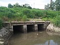
Brick drainage into the Elbe near the mouth hole when the Elbe water level is low

Memorial stone for Ernst Friedrich Wilhelm Lindig in the Pesterwitz cemetery just above the Tiefen Elbstolln


Lindig was buried in the cemetery of the St. Jakobus Church in Pesterwitz in 1852 . His grave was located exactly above the Tiefen Elbstolln. The grave complex has not been preserved, the place is marked by a memorial stone.
Although the light holes were filled after completion, some mining damage occurred. In 1941, a daybreak occurred at the 7th light hole that had to be filled.
Unrealized plans
In addition to drainage, the Elbstolln should also be used for coal transport. The mined coal was to be transported with special barges through the tunnel to the Elbe and transferred there onto Elbe barges . However, this quickly became obsolete due to the rapid development of the railroad at that time.
When planning a deep drainage tunnel for the Freiberg district , chief miner August von Herder considered, among other things, an extension of the Tiefen Elbe tunnel in a western direction, but this variant was discarded in favor of the Rothschönberger tunnel .
use

The deep Elbstolln still serves to drain the Döhlen basin. After most of the mining operations were closed, the then SDAG Wismut took over the tunnel in 1968 .
Investigations after the cessation of bismuth mining revealed heavy silting and partial erosion. Therefore, in 1994, a roughly 85 m deep cavity was sunk near the old Oppelschacht and connected to the tunnel. After the creation of a weather path , it was renovated by Wismut GmbH from January 1997 to June 30, 2006. Mechanical desludging was carried out. The entire drivable length of the tunnel is provided with tracks for the mine railway and supporting structure . A locomotive station with a siding is located about 2650 m from the mouth hole.
In the course of the renovation of the Wismut site in Dresden-Gittersee , the Wismut drove an approx. 3 km long wing location (internally called WISMUT-Stolln ) between shaft 3 and the Tiefen Elbstolln from April 3, 2007 to September 30, 2014, starting on Oppelschacht to enable permanent drainage of the mine water.
On August 9, 2012, the breakthrough from the "Wismut-Stolln" to the Tiefen Elbstolln in Freital-Zauckerode took place. On June 14, 2014, the "Wismut-Stolln" reached the mine building of Shaft 3 in Freital-Burgk. The waterway was created by drilling holes in the mine workings of shaft 3. Since October 7, 2014, the Gittersee / Bannewitz mine field has been drained at an altitude of 120.69 m above sea level. The water inlet is on average 70 m³ / h.
In July 2015, the wooden structure was Gratings of GRP replaced. For this purpose, about 10 meters of rails were laid over days in front of the mouth hole in Cotta in order to simplify the loading and unloading of the mine train.

Mundloch und Gleis (2000)

Mine railway in front of the mouth hole (2000)

U-die near the former Oppelschacht in Zauckerode
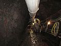
Wismut tunnel, from the foot of the ramp towards the northwest

Runoff into the Elbe at a water level of 86 cm (Dresden water level, 10:00 a.m. on May 28, 2015)

Refurbishment July 2015, left: the yellow GRP gratings; Middle: shield next to mouth hole; right: Locomotive of the mine railway


course
The tunnel leads from the former mines in Freital-Zauckerode in a straight line via Pesterwitz , Gorbitz , Omsewitz and Leutewitz to the Elbe to Dresden- Cotta . The wing location, Wismutstolln, leads from the Oppelschacht over the Osterberg to shaft 3 in Freital-Burgk.
| Landmark | place | year | position | note |
|---|---|---|---|---|
| Mouth hole | Dresden- Cotta | - | 51 ° 3 '46.2 " N , 13 ° 40' 57.2" E | |
| 1. light hole | Dresden- Cotta | - | 51 ° 3 '44.73 " N , 13 ° 40' 53.99" E | In the basement of the Hofbrauhaus |
| 4. light hole | Dresden- Cotta | - | 51 ° 3 '29.78 " N , 13 ° 40' 42.64" O | Today garden at Gottfried-Keller-Strasse 35, Dresden |
| Dump of the 5th light hole | Leutewitz | 1839 | 51 ° 3 '12.92 " N , 13 ° 40' 25.62" E. | Leutewitz windmill |
| 8. Light hole | Pesterwitz | - | 51 ° 1 '32.55 " N , 13 ° 38' 54.22" E | Hunt as a memorial at the entrance to the village |
| 9. Light hole | Freital | - | 51 ° 1 '15.7 " N , 13 ° 38' 39.07" E | wooded heap |
| Oppelschacht | Freital-Zauckerode | - | 51 ° 0 ′ 58.6 " N , 13 ° 38 ′ 24.24" E | Headframe of the former shaft II (Gittersee) |
Individual evidence
- ↑ In Saxony, the spelling Stolln is used instead of Stollen. “Tiefer Elbstolln” as a proper name is spelled correctly.
- ↑ a b c d e f The mining exhibition in the visitors' mine “Daily route Oberes Revier Burgk” in Burgk Castle , 2013
- ^ Yearbook for mining and metallurgy in the Kingdom of Saxony. Born in 1906. (Statistics from 1905.) Published by C. Menzel, KSGeh by order of the Royal Ministry of Finance. Bergrat, PDF ( Memento of the original dated November 9, 2013 in the Internet Archive ) Info: The archive link was inserted automatically and has not yet been checked. Please check the original and archive link according to the instructions and then remove this notice. (25 MB)
- ↑ Bismuth opens a new tunnel. (PDF file; 55 kB) (No longer available online.) Ring Deutscher Bergingenieure , April 3, 2007, archived from the original on November 2, 2014 ; Retrieved on April 25, 2011 (press release from Wismut GmbH). Info: The archive link was inserted automatically and has not yet been checked. Please check the original and archive link according to the instructions and then remove this notice.
- ^ Wismut GmbH (ed.): Dialog . No. 84 , January 2015 (company magazine).
- ↑ Cotta district at www.dresden-und-sachsen.de, accessed September 4, 2014
literature
- Martin Dressel , Jan-Peter Domschke : On the history of the construction of the "Tiefen Elbstolln" between Zauckerode and Briesnitz-Cotta (1817–1837) . in: Sächsische Heimatblätter 59 (2013) 2, pp. 116–125
- Saxon State Office for Environment and Geology / Sächsisches Oberbergamt (Hrsg.): The Döhlener basin near Dresden. Geology and mining. Dresden 2007, ISBN 3-9811421-0-1 . Digitized