Tschenglser Hochwand
| Tschenglser Hochwand | ||
|---|---|---|
|
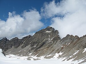
South-east face of the Tschenglser Hochwand seen from the Kleiner Angelusferner |
||
| height | 3375 m slm | |
| location | South Tyrol , Italy | |
| Mountains | Ortler Alps | |
| Coordinates | 46 ° 33 '51 " N , 10 ° 37' 44" E | |
|
|
||
| First ascent | September 3, 1871 by Victor Hecht and the mountain guide Johann Pinggera . | |
| Normal way | from the Zaytalhütte over the southwest ridge | |
The Tschenglser Hochwand ( Italian Croda di Cengles ) is a 3375 meter high summit of the Lasa Mountains in the Ortler Alps , a mountain range in the southern Eastern Alps . It is located in the Italian province of South Tyrol and is part of the Stilfserjoch National Park . The high wall is named after the northern town of Tschengls in Vinschgau . To the north-west, east and south-west it sends pronounced, partly accessible ridges. Seen from the north, the mountain has the shape of a flat rock pyramid. Its north face can only be climbed through difficult rock climbing . Due to its good panoramic view on all sides and easy access from the Düsseldorfer Hütte , it is a summit that is often climbed as a ski tour even in winter . The Tschenglser Hochwand was first climbed on September 3, 1871 by the Prague alpinist Victor Hecht and the mountain guide Johann Pinggera .
Surroundings
Glaciers can only be found on the Tschenglser Hochwand in the east. The Kleine Angelusferner lies south of the east ridge and the Tschenglser Ferner extends to the north . Neighboring mountains along the east ridge are the 3,306 meter high Schafbergspitze , adjoining it to the south, separated by the Zayjoch crossing at 3,224 meters , the Kleiner Angelus at 3,318 meters. In the course of the south-west ridge , about two and a half kilometers away, is the Hintere Schöneck (3,143 m) and along the north-west ridge , at a distance of a good two kilometers, is the Pederfick with a height of 3,114 meters. To the north, the high wall falls down to the Vinschger valley floor, for the Zaytal , which runs from southwest to northeast, it forms the northeastern end of the valley. The next significant settlements are the winter sports resort Sulden (Solda) in the Suldental , which is about five and a half kilometers as the crow flies southwest of the Tschenglser Hochwand, and Tschengls, which is about five kilometers to the north.
Base and ascent
The way from Hecht and Pinggera in September 1871 led from Sulden in the southwest through the Zay valley up to a notch in the southwest ridge of the high face. Their descent led through the Razoital and the Stieralpe back to Sulden. The ascent took them just under five hours. This route is still the normal route today , the easiest ascent. The Düsseldorfer Hütte can serve as a base at an altitude of 2721 meters. Today the path is provided with wire rope insurance in places and is very often used. However, in a channel that leads to the ridge, there is a risk of falling rocks in summer and an avalanche risk for ski mountaineers in winter . According to the literature, the walking time from the hut is around 2½ hours. Other climbs have led since 1899 through the south face ( Erich Otto route ) as a via ferrata , since 1896 over the east ridge with climbing points in UIAA grade III , since 1893 through the 400 meter high north face ( high face ) (UIAA grade III) and as a ridge crossing from the rear Schöneck, committed in 1885 with a key point in UIAA grade III +.
Literature and map
- Peter Holl: Alpenvereinsführer Ortleralpen , 9th edition, Munich 2003, ISBN 3-7633-1313-3
- Hanspaul Menara : The most beautiful 3000m peaks in South Tyrol. 70 worthwhile alpine tours. Athesia, Bozen 2014, ISBN 978-88-8266-911-9
- Journal of the German and Austrian Alpine Club , Volume II , Berlin, Munich, Vienna 1871
- Eduard Richter (editor): The development of the Eastern Alps , Volume II, publishing house of the German and Austrian Alpine Association, Berlin, 1894
- Casa Editrice Tabacco , Tavagnacco: Carta topografica 1: 25,000, sheet 08, Ortles-Cevedale / Ortler area

