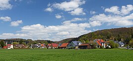
Unterrieden (Altdorf near Nuremberg)
|
Dissatisfied
City of Altdorf near Nuremberg
Coordinates: 49 ° 24 ′ 1 ″ N , 11 ° 23 ′ 36 ″ E
|
|
|---|---|
| Height : | 423 (421-470) m above sea level NN |
| Residents : | 475 (Jan 2, 2017) |
| Incorporation : | January 1, 1978 |
| Postal code : | 90518 |
| Area code : | 09187 |
|
The Altdorf district of Unterrieden
|
|
The village of Unterrieden is a district of the city of Altdorf near Nuremberg in the district of Nürnberger Land in Middle Franconia .
geography
Unterrieden is located about three kilometers northeast of the center of Altdorf and is at an altitude of 423 m above sea level. NHN . The town, not far from the A 6 , is connected to the public road network by the LAU 23 district road; it runs through the town from Oberrieden in the north-east to the south-west towards Altdorf. In the south is Hagenhausen , in the north Pühlheim . The village is largely surrounded by fields and forests.
history
The place name Unterrieden goes back to a cleared piece of land, the term Ried comes from Old High German reod, riod, riodan, which means reuten or clearing . The earliest documentary mention comes from a sales deed from Johann Graf zu Nassau who sold the place to the Burgrave of Nuremberg on June 27, 1360. From 1504 to 1806 the place belonged to the Free Imperial City of Nuremberg . In 1967 a motorway bridge with a length of 540 meters and a height of 48 meters was built nearby; it crosses the Raschbach valley.
With the community edict (1808), the place together with Oberrieden formed the politically independent community of Rieden . On January 1, 1978, this was incorporated into Altdorf as part of the Bavarian regional reform .
Buildings
Geotopes
To the northeast of Unterrieden are the quarries of Ober- and Unterrieden , which are designated as geotopes .
Population development
| year | 1987 | 2013 | 2016 |
|---|---|---|---|
| population | 322 | 450 | 475 |
Web links
- Satisfied in the location database of the Bayerische Landesbibliothek Online . Bavarian State Library
- Undersatisfied on the website of the city of Altdorf (accessed on May 1, 2017)
Individual evidence
- ↑ a b City of Altdorf b. Nuremberg, 2016 population statistics (accessed on November 4, 2017)
- ↑ Location of the district in the Bavaria Atlas (accessed on November 4, 2017).
- ^ Association for Computer Genealogy e. V. ( Page no longer available , search in web archives ) Info: The link was automatically marked as defective. Please check the link according to the instructions and then remove this notice. , Dissatisfied


