Valverde del Camino
| Valverde del Camino municipality | ||
|---|---|---|
| coat of arms | Map of Spain | |

|
|
|
| Basic data | ||
| Autonomous Community : | Andalusia | |
| Province : | Huelva | |
| Comarca : | El Andévalo | |
| Coordinates | 37 ° 35 ′ N , 6 ° 45 ′ W | |
| Height : | 260 msnm | |
| Area : | 218.7 km² | |
| Residents : | 12,820 (Jan 1, 2019) | |
| Population density : | 58.62 inhabitants / km² | |
| Postal code : | 21600 | |
| Municipality number ( INE ): | 21072 | |
| administration | ||
| Mayor : | José Cejudo Sánchez ( PSOE ) | |
| Website : | www.valverdedelcamino.es | |
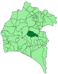
| Location of the municipality | ||

|
||
Valverde del Camino is a small Spanish town in the province of Huelva in the autonomous region of Andalusia . On January 1, 2019, there were 12,820 residents. The urban area extends over an area of 220 km² and is located between the Río Tinto and Odiel rivers. The provincial capital Huelva is around 44 km away. The city has a partnership with Ochtrup ( North Rhine-Westphalia ).
Web links
Commons : Valverde del Camino - Collection of images, videos and audio files
Individual evidence
- ↑ Cifras oficiales de población resultantes de la revisión del Padrón municipal a 1 de enero . Population statistics from the Instituto Nacional de Estadística (population update).
