Galaroza
| Galaroza municipality | ||
|---|---|---|
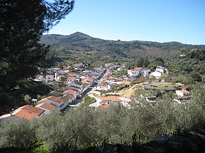
 View from the Avenida de los Carpinteros
|
||
| coat of arms | Map of Spain | |

|
|
|
| Basic data | ||
| Autonomous Community : | Andalusia | |
| Province : | Huelva | |
| Coordinates | 37 ° 56 ′ N , 6 ° 42 ′ W | |
| Height : | 568 msnm | |
| Area : | 22.27 km² | |
| Residents : | 1,379 (Jan 1, 2019) | |
| Population density : | 61.92 inhabitants / km² | |
| Postal code : | 21291 | |
| Municipality number ( INE ): | 21034 | |
| Nearest airport : | Huelva | |
| administration | ||
| Official language : | Castilian | |
| Mayor : | Antonio Sosa Muñiz ( PSOE ) | |
| Website : | www.galaroza.org | |
Galaroza is a Spanish municipality in the province of Huelva in Andalusia . The community is known for its water and handicraft woodwork.
Geographical location
Galaroza is located around 60 km north of the city of Huelva in the Sierra de Aracena y Picos de Aroche National Park . The nature of the terrain meant that Galaroza was arranged in the form of an arch to the north around the Santa Brígida hill .
Administrative structure
Galaroza belongs to the Mancomunidad Ribera de Huelva . In addition to the main town, the hamlets of Las Chinas and Navehermosa belong to the municipality .
history
No evidence of prehistoric settlement was found.
The origin of the community is unclear. It could be an Arab foundation from the time of al-Andalus . The name could come from the Arabic Al-Jaroza . The term has different meanings: valley of the roses, valley of the evergreen, valley of the bride. Legend has it that a Berber prince named Ysmail got lost in the forest while looking for a woman who had bewitched him.
Up to and including the 12th century, the community belonged to Arab rule. It belonged to Portugal in the 13th century until it fell to the Kingdom of Castile with the Treaty of Badajoz in 1267 . In the Middle Ages it was part of the judicial district of Aracena . In 1553 it became independent. At that time, it included the villages of Fuenteheridos, Las Vegas, Cortegrullo and Las Cañadas in addition to the current districts.
In 1594 Galaroza and its villages belonged to the Kingdom of Seville in the Sierra de Arroche. It had 290 taxable citizens.
In the 1842 census it was called Galarosa .
Historical buildings
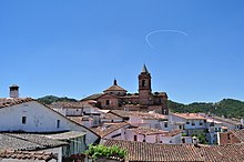
- Parish Church of Purísima Concepción , 17th century.
- San Sebastián Chapel , 18th century
- Santa Brígida Chapel , 14th century
- Fuente de doce caños (Fountain with twelve tubes), 1898
population
In the last few decades the population of the municipality has shrunk, as the following series of numbers shows:
| year | 1842 | 1877 | 1887 | 1897 | 1900 | 1910 | 1920 | 1930 | 1940 | 1950 | 1960 | 1970 | 1981 | 1991 | 2001 | 2011 | 2017 |
| Residents | 1,824 | 2,375 | 2,410 | 2,647 | 2,683 | 2,861 | 2,851 | 2,792 | 2,748 | 2,586 | 2,642 | 2.224 | 1,844 | 1,603 | 1,618 | 1,565 | 1,409 |
| settlement | Male | Female | total |
|---|---|---|---|
| Galaroza | 1443 | 705 | 738 |
| Las Chinas | 18th | 10 | 8th |
| Navahermosa | 42 | 25th | 17th |
Personalities
- José Joaquín Romero y Fernández de Landa (1735–1807), first marine engineer in the Real Armada
- Tío José el Granaíno (probably 1818 – unknown), torero and flamenco singer
Web links
- galaroza.org Website of the municipality
Individual evidence
- ↑ Cifras oficiales de población resultantes de la revisión del Padrón municipal a 1 de enero . Population statistics from the Instituto Nacional de Estadística (population update).
- ^ Ministerio de Hacienda y Administraciones Públicas, Portal de entidades locales
- ↑ Galaroza. In: Guía digitál del patrimonio culturál de Andalucía. Junta de Andalucía, Retrieved May 8, 2019 (Spanish).
- ^ Libro de los Millones : Census of the provinces and parts of the Kingdom of Castile in the 16th century
- ^ INE : Cifras de población y Censos demográficos. ( ine.es ).
- ↑ INE: Nomenclator : Población del Padrón Continuo por Unidad Poblacional.


