
Viktring
| 13. Klagenfurt district of Viktring |
|
| surface | 18.67 km² |
| Geographical location | 46 ° 35 ' N , 14 ° 17' E |
| height | 453 m above sea level A. |
| Residents | 9515 (January 1, 2020) 510 inhabitants per km² |
| Post Code | 9073 |
 |
|
|---|---|
Viktring ( Slovenian : Vetrinj ) is the 13th district of the state capital Klagenfurt am Wörthersee in Austria .
geography

Viktring is located in the south of Klagenfurt at the foot of the Goritschnigkogel (683 m) and at the entrance to the Keutschacher Valley. In the north, the Glanfurt (Sattnitz) forms the border with the districts of St. Martin and St. Ruprecht. The district also borders the communities of Maria Wörth , Keutschach am See , Köttmannsdorf , Maria Rain and Ebenthal in Carinthia .
history


Viktring was first mentioned in 977 as Vitrino (Celtic Knüttelfeld) and gained great importance through the founding of the Cistercian monastery by Count Bernhard von Marburg in 1142. The Viktring monastery developed into one of the largest and richest in Carinthia and was until its abolition in the year 1786 religious and cultural center of the region. After changing ownership, the monastery was acquired by the Republic of Austria in 1970 and a “Realgymnasium with a creative focus” (music high school, see BRG Viktring ) was set up in 1977 .
After the First World War, southern Carinthia was claimed by the Kingdom of Serbs, Croats and Slovenes. In the "Carinthian referendum" of 1920, the people of southern Carinthia were free to decide, Viktring was part of the voting area. 82.3% of the Viktringer population voted to stay with Austria. A memorial plaque on the Glanfurt Bridge on Rosentaler Straße reminds us today that a state border would run here if the people of southern Carinthia had made a different decision at the time.
At the end of the Second World War, the FLAK positions against the Allied air raids were set up on the Straschitzer Plateau, which rises around twenty meters above the plain and extends northwards towards Klagenfurt as the tongue of the Sattnitz Ridge .
After the Second World War , 17,000 Slovenian civilians and Landwehr soldiers and Serbian Chetnik associations, including a smaller number of Croats , fled to Viktring from the communist Tito regime in early May 1945 and set up a refugee camp for several weeks at the "Viktringer Feld". 11,000 Landwehr soldiers were repatriated to Yugoslavia in May and June 1945; An unknown number of members of the Yugoslav People's Army were murdered on the marches there and in the internment camps . First (mid-May) most of the Croats and Serbs were handed over to the Yugoslav People's Liberation Army, at the end of May / beginning of June 1945 most of the Slovenes from the Viktring camp near Klagenfurt . In Slovenia these massacres are known today as the "Drama about Viktring" or the tragedy of Viktring, in Croatia as the Bleiburg massacre or the "Bleiburg tragedy".
In 1973 Viktring was incorporated into the city of Klagenfurt together with a small part of the community of Maria Wörth (around today's Bad Maiernigg).
Today this district in the immediate vicinity of the Wörthersee is a popular residential area and the former abbey as a secondary school is a place of musical training and a splendid setting for artistic events.
The city keep - anno 1556

Klagenfurt was more than a collection of buildings within the city fortifications. The area of influence included extensive corridors in the hinterland and their small towns. They formed the keep where the city judge still held his office. From St. Primus in the north to the marshland of the Glanfurt in the south and from the Glan in the east to the village of Waidmannsdorf in the west, they were a family. Not a single castle was built in this area, the aristocratic residences of this type were all outside the boundaries of the keep, but formed a sparkling diadem for the city.
The keep preparations took place at longer intervals. These are to be understood as solemn border inspections to which the neighboring regional courts and manors have been invited, in order to resolve any problems that have arisen in the meantime, if possible, on the spot and to be able to part again in peace.
The castle keep on the Glanfurt ended in St. Ruprecht. For a long time, the Seebach, as the border between the Viktring monastery and its neighbors, and the city of Klagenfurt, was an object of contention. In 1198, for example, it was about the use of grass. An arbitration decision clarified - the seven hills were still owned by Viktringer. That was a first fixed point. Another arbitration award dates from 1391. This time it was about a pasture in the area of Waidmannsdorfer Lacke. It was awarded to the city of Klagenfurt as municipal pasture, but with the restriction that the cattle of the monastery subjects could also be driven there to Postraschischnig and Stein. The people of Klagenfurt were also given a willow on the right bank of the Glanfurt. Boundary stones were set to mark the course of the border. One such stone stood in the moss near what would later be the paper mill, another on the platform of the Sattnitzbauer estate. The citizens of Klagenfurt also had the right to fish in this section of the brook, which they tried to dispute. When the smelter mill was built, there was again trouble. A comparison was made in the form that the grain mill did not have to be demolished, but the Klagenfurters had to build a lock in the dam, which had to be opened on public holidays and, according to old tradition, also when the lake drainage lock was open so that the fish could catch the fish could get down the drain. In 1423 the Salzburg regional court tried for its part to move the villages Waidmannsdorf, Flatschach (= St. Ruprecht) and St. Peter, which had once belonged to Salzburg, into their keep. The request was rejected.
The border inspections were so important because the land had not yet been surveyed and there were no corresponding land register plans that could have been invoked. A clandestine shift of borders was therefore possible at any time and a claim that had been made could not be disproved easily. In order to be able to summon witnesses, many young people were taken along to the preparations for the castle keep. On this occasion, the next generation was given castle cemetery pennies, which were thrown among the young participants on the way. Around 1200 coins were minted for this purpose in 1729. To check the boundaries of the castle keep, armed and mounted crews, flags and sounding games were deployed in late summer or autumn when the fields were harvested and the damage to the fields was limited. In order to prevent excessive drunkenness and brawling, one had to adhere to its own instructions.
The rhyming chronicler Paul Kheppiz tells us the first preparations for the keep, from the years 1538 and 1556. The boundaries were of greater importance at this time, as the city judge ruled on the life and death of an offender in addition to civil jurisdiction. The execution sites (Schindanger) in Annabichl am Galgenbichl and later on a property between Rosentaler Straße and Viktringer train station can be traced back to this. Opposite the Künstl forwarding company, on the other side of Rosentaler Straße, the gallows cross was in a niche in the wall for a long time. Up to this point a criminal was accompanied by the priest on his last journey.
In 1575, the castle keepers moved up the Glanfurt from the Glan to the ford in St. Ruprecht. Since there were no complaints from the local residents or from the city, they moved on to the big stone at the Sattnitzbauer, where the owner of the Hollenburg estate and his officials were present. The representatives of the Viktring Abbey were waiting by the mill in the smelter, who had still not come to terms with the fact that the mill object was on Klagenfurt soil. After lunch had been eaten at several tables, the infantry first set out again and marched up the stream to Siebenhügel, in order to turn off from there to the second loin bridge.
In 1603 some of the people on the other side of the Glanfurt moved from the cool Brünnl (one of the two springs at the Sattnitzbauer) to the Haklberg. After the smelter mill, Siebenhügel and the Paternionerbrücke were the next stops. In 1631 the citizenry went in two groups from the castle keep boundaries of Klagenfurt.
Administrative division
Viktring is divided into four cadastral communities and the following localities.
-
Goritschitzen (Slov. Goričica ):
- Alps (Slov. "Planina pri Vetrinju"), Goritschitzen (Slov. Goričica ), Krottendorf (Slov. Krotna vas )
-
Neudorf (Slov. Nova vas ):
- Bach (Slov. Potok ), Berg (Slov. Gora ), Kreuth (Slov. Rute ), Lak (Slov. "Loka pri Vetrinju"), Neudorf (Slov. "Nova vas"), Straschitz (Slov. "Pestrazisce pri Vetrinju ")
-
Stone (Slov. Zakamen ):
- Kerbach, Lugin, Stein
-
Viktring : (Slov. "Vetrinj")
- Migoriach (Slov. Megorje ), Sacrificial Wood (Slov. Vožnica ), Thal (Slov. "Lipica"), Seebach (Slov. "Jezerca pri Vetrinju"), Viktring (Slov. "Vetrinj")

Straschitz

Stifterkogel with the village of Bach

Bach village

Hamlet "Lak"


Culture and sights
Buildings
-
Viktring Abbey with a late Romanesque three-aisled abbey church based on the Burgundian model. Noteworthy in the collegiate church:
- the Romanesque south portal
- the five-storey early baroque high altar
- Gravestones from the 13th and 15th centuries
- 60 Gothic glass paintings on the choir windows depicting scenes from the life of Christ, Mary and the apostles.

Viktring Collegiate Church: east view
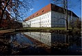
Viktring Abbey

Interior of the collegiate church

Viktring Collegiate Church: high altar and stained glass


-
Parish church Viktring-Stein , in the district of Stein east of Viktring, raised on a hill. The following are remarkable about the parish church:
- Empire tombstones of the Moro family (outside on the southern nave wall)
- Bronze bust of Max Ritter von Moro (outside)
- Ceiling painting Martyrdom of St. Florian (inside)
- the uniform late rococo facility (inside)
- Other structures
- Villa Miller-Aichholz at Stift-Viktring-Straße 14
- Fischerkeusche on the Koschatpromenade
- Prelature of the Cistercian monastery Viktring at Stift-Viktring-Straße 25
- Landmarks
- Boundary stone "BV 1763" in sacrificial wood
- Stadt-Burgfriedstein - Anno 1556 on Quellenstrasse
Regular events
- Viktring Music Forum
- Viktring large flea market (with over 600 stalls, it is one of the largest flea markets in Austria)
Economy and Infrastructure
traffic

Viktring can be reached from the city center via Rosentaler Straße towards Ferlach. About 3 kilometers outside of Viktring is the Viktring train station, which is now privately owned. The new Klagenfurt Süd station was built nearby. On the former Rosentalbahn , the S3 now runs every hour from Monday to Friday to Weizelsdorf, from Weizelsdorf to Rosenbach public transport is maintained by the ÖBB-Postbus bus line.
fire Department
In 1924 the Viktring volunteer fire brigade emerged from the former company fire brigade of the Moro cloth factory , which as a branch fire brigade was under the command of the local Stein / Neudorf fire brigade. Valentin Abraham was elected as their branch manager. In 1926 the time had come: Valentin Abraham, Steigerleitmann, who was also the branch manager in Viktring, was invited to the inauguration of the syringe house on August 15, 1926 and then to the big folk festival. In 1969, following a municipal council resolution, the Stein-Neudorf fire brigade and the Viktring fire brigade were merged - and this resulted in the "Viktring-Stein / Neudorf" volunteer fire brigade.
In June 1970 the long-awaited groundbreaking ceremony took place on the occasion of the construction of a large modern fire station in Stein, which took place in the presence of the mayor of Viktring at the time, Josef Pollessnig, the local councils and the fire brigade comrades. As a result of the incorporation of Viktring to Klagenfurt in 1973, the Viktring-Stein / Neudorf volunteer fire brigade is one of the ten volunteer fire brigades in the state capital of Klagenfurt.
Public facilities
Library
- Viktring Public Library
education
- Bundesrealgymnasium Klagenfurt-Viktring
- Thomas-Koschat Secondary School Viktring-Klagenfurt (HS 13)
- Primary schools in Viktring: VS19 and VS20
Personalities
Viktring's sons and daughters
- Johann von Viktring (1270–1347), abbot and historian
- Thomas Koschat (1845–1914), composer and choir director
Bibliography
Individual evidence
- ↑ Statistics Austria: Population on January 1st, 2020 by locality (area status on January 1st, 2020) , ( CSV )
- ^ Anton Kreuzer: St. Ruprecht - City in front of the city. Klagenfurt's XI. District . Kreuzer-Buch, Klagenfurt 2009
literature
- DEHIO Carinthia. Topographical inventory of monuments , pp. 997–1004. Verlag Anton Schroll & Co, Vienna 2001, ISBN 3-7031-0712-X
- KK Central Commission for Research and Conservation of Art and Historical Monuments: Art Topography of the Duchy of Carinthia , Vienna, 1889, p. 321; Pp. 362-370; from the KK Hof- und Staatsdruckerei
- Anton Kreuzer: Viktring and its surroundings. The XIII. Borough . Kreuzer-Buch, Klagenfurt 2010, Einigkeitsstraße 3, 9020 Klagenfurt
Web links
