
Annabichl
| 9. Klagenfurt district Annabichl slow. Trna vas |
|
| surface | 21.93 km² |
| Geographical location | 46 ° 39 ′ N , 14 ° 18 ′ E |
| height |
476 m above sea level A. (Ehrental Castle) |
| Residents | 11,300 (January 1, 2020) 515 inhabitants per km² |
| Post Code | 9020, 9026 |
 |
|
|---|---|
Annabichl (Slov. Anapigelj) is the 9th district of the state capital Klagenfurt am Wörthersee ( Austria ). The Klagenfurt Central Cemetery and Klagenfurt Airport are located in Annabichl .
geography
Annabichl is located in the north of Klagenfurt adjacent to the St. Veiter Vorstadt district . The district border runs in the west south of the villages of Trettnig and Lendorf along the Dellacher Weg - Grenzweg line, in the south along the Falkenbergweg and Trettnigstrasse, the Glan river to Pischeldorfer Strasse and in the east along the Dammgasse - Karl-Friedrich-Gauß-Strasse line , crosses the airfield of the airport and continues along Drasendorfer and Nessendorfer Strasse south of the villages of Atschalas, Drasendorf and Nessendorf. Annabichl borders the market town of Maria Saal in the north .
The highest point is the Maria Saaler Berg (746 m), which is not located in the municipality of Maria Saal, but in Klagenfurt. Other elevations are the Ehrentaler Berg (508 m), the Spitalsberg (498 m) and the Galgenbühel (477 m).
history

The name is derived from Annabichl Castle , which Georg Khevenhüller had built for his second wife Anna in 1580.
From 1528 the Klagenfurt execution site ( Galgenbichl ) was located here , but this was later moved to the south of Klagenfurt (to today's Rosentaler Straße).
In Annabichl, at the foot of the Spitalberg towards the Glan, Hermann von Spanheim founded the first Klagenfurt. Since the small market was repeatedly flooded by the Glan, his son Bernhard von Spanheim moved Klagenfurt to its present location in 1246.
The formerly independent community Annabichl was incorporated into the city of Klagenfurt on October 15, 1938, together with part of the community Lendorf (today's cadastral community Waltendorf).
The old Slovenian name for Annabichl is Gorčica (= small hill, Bichl).
Glan regulation by Josef Eckert
-Anna-Josef_(Vater)-Rosa_Eckert_(um_1900).jpg)
Around 1900 the Glan flowing through the Annabichl district was regulated under the direction of the meadow technician Josef Eckert . This encroachment on nature means straightening a meandering river course as well as draining wetlands and wet meadows through drainage measures in the catchment area of rivers . The rapidly growing population of the 19th century required these measures to enlarge the agricultural cultivation areas and arable land.
Administrative division
Annabichl is divided into three cadastral communities and the following localities.
-
Ehrental :
- Annabichl, Ehrental, Feschnig, Tessendorf
-
Marolla :
- Atschalas, Drasendorf, Gorintschach, Judendorf, Marienhof, Marolla, Nessendorf, St. Georgen am Sandhof, Steinbeis, Terndorf
-
Waltendorf :
- Waltendorf, Winklern
Free time and leisure
Hiking trails
Maria Saaler Berg
A pilgrimage route leads from Terndorf via Marolla along the western flank of the Maria Saal mountain to the Maria Saal cathedral . Especially in the month of May, devout pilgrims walk the forest path in devotion. Rosaries are prayed and the numerous votive pictures on trees are stopped in order to devote oneself to the veneration of Mary.

Maria Saaler hiking trail in Marolla, Schumystraße junction

Falkenberg, Trettnig, Waltendorf, Winklern
Between the Falkenberg, Trettnig and Waltendorf there are well-marked paths through mixed forests, meadows and wetlands.

From Falkenberg Castle to Trettnig

Glanpark of the state capital Klagenfurt
The park is bordered in the south by the Glan , in the west by the LKH car park on Grete-Bittner-Strasse and in the north by Feschnigstrasse. The cycle path leading through the green area along the Glan River is lined with park benches, and wooden loungers ensure the recreational character of the facility. An inscription stone in honor of the namesake for the adjacent flowing water can be found in the middle of the green areas. Wooden play equipment motivates children to stay.
The Glanpark was built in 2005 and 2006 by the state capital Klagenfurt with the cooperation of the LKH Klagenfurt and the state hospital operating company (KABEG). The state capital Klagenfurt, City Garden Department, is responsible for ongoing care and maintenance.
On the basis of the Carinthian State Security Police Act (LGBl. 74/1977 as amended), the City Council of Klagenfurt has declared the Glanpark to be a no-dog zone. Dogs may not be taken into the no-dog zone. Dogs are not allowed to enter the no-dogs zone. In the event of violations, the dog owner is to be punished by the district administrative authority with a fine of up to € 2,500, in the case of recurrence up to € 5,000.
A dog free zone is located 300 meters west of the Glanpark between Grete-Bittner-Straße and Glan in the green area immediately west of the Red Cross headquarters.

Glan in the new river bed

Inscription stone in honor of the Celtic god "Glanos"


Parishes and Churches
Catholic Church
The district is divided into two Catholic parishes:
Parish Annabichl
- Parish Church Klagenfurt-Annabichl To the Precious Blood
- Church of Tessendorf

Parish church of the “Precious Blood” in Thomas-Schmid-Straße

Filial church "Heiliger Bartholomäus" in Tessendorf


Parish St. Georgen am Sandhof
- Parish Church of St. Georgen
- Church of St. Ulrich in Krastowitz

Parish church Sankt Georgen am Sandhof

New Apostolic Church
There is also a congregation of the New Apostolic Church in the district.
Buildings and sights
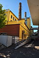
Schleppe brewery and rock cellar
Beer has been brewed in the Schleppe brewery for over 400 years. The historic buildings date from 1827.

Schleppe Brewery
Schleppe brewery, detail

Gasthaus Felsenkeller


Khevenhüller barracks and soldiers' houses
Construction of the barracks began in 1938. The buildings are in the Upper Bavarian style with projecting roof beams, quarry stone masonry and shingle roofs. At the same time as the barracks, the Koglstrasse settlement was built to provide housing for the officers. Today it is in private hands. The gym of the barracks was probably completely destroyed by arson in 1943. The soldiers' church was built in its place from April 1966 to October 1968.

Soldiers accommodation building

Soldiers Church in Lendorf

Soldiers housing estate in Waltendorf


Ingeborg Bachmann's birthplace
Ingeborg Bachmann's birthplace is at 35 Durchlaßstraße. The simple suburban residential building with a wooden balcony was built at the end of the 19th century and its appearance has been changed to this day. It is mentioned in Bachmann's volume of stories "The Thirtieth Year".

Ingeborg Bachmann's birthplace (Durchlaßstrasse 35)

Gothic wall granary in Tessendorf
This example, which is very rare for the urban area of Klagenfurt, is located at Tessendorfer Straße 124 and the construction is given as late 15th / early 16th century. This old " Schüttkasten " received in 18./19. Century a north-eastern extension. The building emerged from an Edlingerhof. In the northwestern interior there is a groin vault with trimmed ridges. A restoration took place in 1998.

Gothic wall granary in Tessendorf
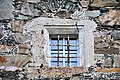
South window in the Gothic wall granary in the Tessendorf district


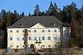
Castles
Annabichl Castle
Ehrenhausen Castle
Ehrental Castle
Falkenberg Castle
Mageregg Castle
St. Georgen Castle at Sandhof
Krastowitz Castle

Annabichl Castle

Ehrenhausen Castle
Ehrental Castle

Falkenberg Castle

Mageregg Castle

Sankt Georgen Castle at the Sandhof

Krastowitz Castle


Economy and Infrastructure
- Central cemetery Annabichl , the largest cemetery in Klagenfurt
- Klagenfurt International Airport (half of the runway, however, is in the St. Peter district)
- Laudon and Khevenhüller barracks
- Schleppe Brewery
- Business park in the “Schleppe-curve” on Feldkirchner Straße

Business park in the train curve

Mediaprint Center with the Kronen Zeitung in the Business Park on Feldkirchner Strasse


Public transport
In Annabichl there is a train station on the Südbahn ( ÖBB timetable picture 601). The station is called Klagenfurt Annabichl . Several bus lines run by Stadtwerke Klagenfurt run through the Annabichl district :
- Lines 40 and 42 run from the Sonnengasse stop in the district. Drive along St. Veiter Straße to the Annabichl station . Line 40 then continues a loop via Tessendorf to Walddorf, line 42 a loop to the airport, to St. Georgen am Sandhof and Terndorf.
- Line 41 runs from the turning from St. Veiter Straße into Feschnigstraße in the district and then travels via the districts of Feschnig and Ehrental to the final stop at Annabichl station .
- Lines 30 and 32 go via Feldkirchner Straße to Wölfnitz and are located between the Schleppe and Lendorf Ort stops in the Annabichl district.
- Line 31 runs from the Spitalbergweg stop at the beginning of Feschnigstrasse in the district. It then travels like line 41 via the district of Feschnig. Via Suppanstraße, the line goes to Feldkirchner Straße and is then on the way to Wölfnitz like lines 30 and 32 to the Lendorf Ort stop in the Annabichl district.
All these lines run on the return journey over the same route as on the outward journey.
Night lines run after around 8 p.m., two of which serve the Annabichl district:
- Line 93 runs over Feldkirchner Straße to Wölfnitz and, like the corresponding day lines, is located between the Schleppe and Lendorf Ort stops in the district.
- Line 94 is located in the district when you turn from St. Veiter Straße into Feschnigstraße and then leads via the districts of Feschnig and Ehrental to Annabichl station. From there it runs on the return trip via St. Veiter Straße and leaves the district after the Sonnengasse stop .
This line overview is current from June 2016.
education
Elementary schools
- VS 4 Annabichl
- VS 13 Am Spitalberg
- VS 15 St. Georgen am Sandhof
More schools
- NMS 11 Annabichl Viktor Frankl School (New Middle School)
- Agricultural college Ehrental (technical and vocational school)
literature
- Annabichl and St. Veiter Straße , Anton Kreuzer / Johann Jaritz, Klagenfurt 2009, Kreuzer Buch, Einigkeitsstraße No. 3, 9020 Klagenfurt
- Lendorf and Feldkirchner Strasse , Anton Kreuzer / Johann Jaritz, Klagenfurt 2008, Kreuzer Buch, Einigkeitsstrasse No. 3, 9020 Klagenfurt
Individual evidence
- ↑ Statistics Austria: Population on January 1st, 2020 by locality (area status on January 1st, 2020) , ( CSV )
- ↑ Directory of place names ( memento of the original from December 21, 2014 in the Internet Archive ) Info: The archive link was inserted automatically and has not yet been checked. Please check the original and archive link according to the instructions and then remove this notice. (PDF; 146 kB), accessed February 27, 2014.
- ^ Schleppe history 1827-1872. Retrieved April 15, 2020 .
- ↑ The Khevenhüllerkaserne. Retrieved April 15, 2020 .
Web links
- Entry on Annabichl in the Austria Forum (in the AEIOU Austria Lexicon )
