Desert Dittersdorf
|
Desert Dittersdorf
City of Schleiz
Coordinates: 50 ° 34 ′ 38 " N , 11 ° 50 ′ 57" E
|
||
|---|---|---|
| Height : | 425 m above sea level NN | |
| Postal code : | 07907 | |
| Area code : | 03663 | |
|
Location of Wüstendittersdorf in Thuringia |
||
|
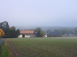
View of the place
|
||
Wüstendittersdorf is a district of Schleiz in the Saale-Orla district in Thuringia .
geography
The village is located east of the town of Schleiz on the federal road 94 to Zeulenroda via Lössau and Weckersdorf in the Thuringian part of the Vogtland . The village flows through the Wisenta , which flows into the Saale .
Geologically, the area is located in the southeast Thuringian slate mountains . These soils are very productive due to the high proportion of fine soil and the high humus content . The loosely populated place lies in a grassland-rich hollow surrounded by forest.
Neighboring places
Neighboring towns are Schleiz, Oettersdorf , Lössau, Langenbuch and Oberböhmsdorf .
history
Wüstendittersdorf was first mentioned in a document on April 22nd, 1232. In 1402 the town of Schleiz bought the village and farm Wüstendittersdorf.
In 1872 the rock "Teufelskanzel" or "Teufelspredigerstuhl", which stood near the Kühn or Burhardtsmühle, was blown up. In the upper part of the rock there should have been depressions or pits and steps. This rock was probably used for cult rituals.
economy
The place has always been of great agricultural interest. In 1690 Thomas Heller bought the estate . It was family-owned until 1956. Then an agricultural production cooperative (LPG) was set up.
After 1989, many residential buildings were built in the village.
traffic
The Wüstendittersdorf stop is on the Schönberg – Schleiz railway line . The line is leased from DB Netz AG to Deutsche Regionalisenbahn . There is no longer any regular passenger traffic. Occasionally there are special trips.
In the 2017/18 timetable, Wüstendittersdorf is connected to public transport by the following line :
- Line 132: Schleiz - Wüstendittersdorf - Zeulenroda
The line is operated by KomBus .
Individual evidence
- ↑ Manfred Graf: Organization of the cooperative plant production with a high proportion of grassland in the southeast Thuringian slate mountains. Shown at the KOG "Lobenstein". 1970, (Jena, University, dissertation, 1970; typed).
- ^ Wolfgang Kahl : First mention of Thuringian towns and villages. A manual. 5th, improved and considerably enlarged edition. Rockstuhl, Bad Langensalza 2010, ISBN 978-3-86777-202-0 , p. 242.
- ^ History of Schleiz. In: Website of the city of Schleiz. Schleiz city administration, accessed on February 4, 2017 .
- ↑ Michael Köhler: Pagan sanctuaries. Pre-Christian places of worship and suspected cult sites in Thuringia. Jenzig-Verlag Köhler, Jena 2007, ISBN 978-3-910141-85-8 .
- ^ Wüstendittersdorf on the website of the city of Schleiz ( Memento from March 5, 2016 in the Internet Archive ). Retrieved on February 4, 2017.


