Waldenburger Oberwald
|
Waldenburger Oberwald
Large district town Hohenstein-Ernstthal
Coordinates: 50 ° 49 ′ 31 ″ N , 12 ° 41 ′ 13 ″ E
|
||
|---|---|---|
| Area : | 1.89 km² | |
| Incorporation : | 1999 | |
| Postal code : | 09337 | |
| Area code : | 03723 | |
|
Location of Waldenburger Oberwald in Saxony |
||
Waldenburger Oberwald is one of four parishes of the large district town Hohenstein-Ernstthal in the district of Zwickau in Saxony . The forest area once belonged to the Schönburg rule of Waldenburg . Around 1920 the forest district was incorporated into Kuhschnappel and reclassified to Hohenstein-Ernstthal in 1999.
geography
Geographical location and traffic
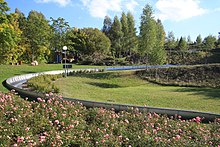
The Waldenburger Oberwald is the only district of Hohenstein-Ernstthal that is north of the federal motorway 4 . This forms the southern border. The forest area belongs to the Rabensteiner ridge , which lies on the transition from the northern edge of the Erzgebirge basin and the southern edge of the central Saxon loess loam hill country . The serpentinite quarry Oberwald and the Karl-May-Höhle are in the district . In the west, part of the " Oberwald reservoir " recreation area with the Karl May stage and the summer toboggan run is part of the district. The Waldenburger Oberwald is part of the "Pfaffenberg-Oberwald" nature reserve.
Neighboring places
| Reichenbach | Hawks | |
| Obercallenberg |

|
Langenberg |
| Hohenstein |
history
The forest district of Oberwald historically belonged as a forest district to the Schönburg dominion of Waldenburg .
During mining exploration work, several tunnels were probably excavated in the Oberwald from the 17th century . The main search was for iron ore; was found serpentinite . One of these tunnels is the Karl May Cave , which dates back to 1620 as a mining facility. Already in the 18th century it was used by robber gangs as a hideout and called the robber cave. In 1869, when the 27-year-old Karl May (1842–1912) came into conflict with the law on several occasions because of theft , he used this cave as a hideout and hiding place for his belongings.
After an administrative reform was carried out in the area of the Schönburg recession in 1878, the Waldenburger Oberwald came in 1880 as a manor district under the administration of a district forester as head of the newly established royal Saxon administration of Glauchau . The serpentinite quarry in Oberwald was opened up in 1906 by workers from the Zöblitz serpentine quarries . The mined material was taken to Zöblitz by train , as the processing industry was based there. It was used for the production of arts and crafts and as an architectural design element, such as the altar feet of the Hohenstein Church of St. Christophori. In the 1930s, the material was increasingly needed for structural purposes, including the construction of the Reichsautobahn between Dresden and Meerane , now the A4 federal motorway . From 1945 mining was reduced and in 1972 it was stopped entirely.
After the Free State of Saxony was proclaimed in 1918, the independent manor districts were dissolved. The Oberwald manor district was assigned to the Kuhschnappel community around 1922 . As a result of the second district reform in the GDR , the Waldenburger Oberwald came to the Hohenstein-Ernstthal district in the Chemnitz district as part of the Kuhschnappel community in 1952 (renamed the Karl-Marx-Stadt district in 1953 ). In the same year took place in the corridors of the western neighboring town Upper Callnberg the digestion of nickel mining Callenberg South I , which, after the closure of 1,977 in 1982 as a reservoir Oberwald opened. The Karl May stage and the summer toboggan run of the leisure area are located in the corridors of the Waldenburger Oberwald.
On April 1, 1996, the Waldenburger Oberwald became part of this municipality with the incorporation of Kuhschnappel into St. Egidien. The reclassification of the Waldenburger Oberwald district to Hohenstein-Ernstthal took place on January 1, 1999.
Since July 10, 2002, the Waldenburger Oberwald has been part of the "Pfaffenberg-Oberwald" nature reserve.
Attractions
Web links
Individual evidence
- ↑ Land use plan of the Sachsenring urban association , p. 20, (PDF; 1.2 MB, [accessed on April 19, 2020].)
- ^ The "Pfaffenberg – Oberwald" nature reserve on the Zwickau district website. Retrieved April 19, 2020.
- ^ Karlheinz Blaschke , Uwe Ulrich Jäschke : Kursächsischer Ämteratlas. Leipzig 2009, ISBN 978-3-937386-14-0 ; P. 92 f.
- ↑ The Oberwald forest district as part of the Princely Schönburg Forest Inspectorate in Waldenburg in the State Archives of the Free State of Saxony. Retrieved April 19, 2020.
- ^ Gert Ueding / Klaus Rettner: Karl May Handbook . Königshausen & Neumann, 2001, ISBN 978-3-8260-1813-8 , pp. 82 .
- ↑ Files of the rule Waldenburg in the state archive of the Free State of Saxony Retrieved on April 19, 2020.
- ^ The Glauchau district administration in the 1900 municipal register. Accessed on April 19, 2020.
- ↑ File on the incorporation of the Oberwald manor district into Kuhschnappel in the State Archives of the Free State of Saxony. Retrieved April 19, 2020.
- ↑ Kuhschnappel on gov.genealogy.net. Retrieved April 19, 2020.
- ↑ StBA: Changes in the municipalities of Germany, see 1999. Accessed on April 19, 2020.
- ^ The "Pfaffenberg – Oberwald" nature reserve on the Zwickau district website. Retrieved April 19, 2020.


