Hohenstein (Hohenstein-Ernstthal)
|
Hohenstein
Large district town Hohenstein-Ernstthal
Coordinates: 50 ° 48 ′ 9 ″ N , 12 ° 42 ′ 26 ″ E
|
||
|---|---|---|
| Area : | 1.89 km² | |
| Incorporation : | 1898 | |
| Postal code : | 09337 | |
| Area code : | 03723 | |
|
Location of Hohenstein in Saxony |
||
Hohenstein is a district of the large district town Hohenstein-Ernstthal in the district of Zwickau in Saxony . In 1898 it was united with the city of Ernstthal to form the city of Hohenstein-Ernstthal.
geography
Geographical location and traffic
Hohenstein forms the western part of the city center of Hohenstein-Ernstthal. To the northeast of the district is the Pfaffenberg , ( 479 m above sea level ) which lies on the transition from the northern edge of the Erzgebirge basin and the southern edge of the central Saxon loess loam hill country . The Pfaffenberg belongs to the "Pfaffenberg – Oberwald" nature reserve. The Hüttengrundbach and Goldbach brooks running through Hohenstein drain over the Lungwitzbach into the Zwickauer Mulde .
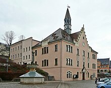
The historical origins of Hohenstein with the Church of St. Christophori and the town hall on the Altmarkt are in the north of the district.
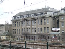
North of the Hohenstein extending Bundesautobahn 4 , the connection point Hohenstein-Ernstthal is northwest of the neighborhood. The federal highway 180 , which touches Hohenstein in the west, leads to it. In the southern part of Hohenstein the Dresden – Werdau railway runs with the Hohenstein-Ernstthal train station . The Hohenstein-Ernstthal-Oelsnitz tram began there between 1913 and 1960 . The Hohenstein-Ernstthal , Hohenstein-Ernstthal freight depot , August-Bebel-Straße and depot station were in the Hohenstein corridor .
Neighboring places
| Obercallenberg | Waldenburger Oberwald | Langenberg |
| Kuhschnappel with Tirschheim |

|
Ernstthal |
| Hermsdorf | Oberlungwitz |
history
The first mining attempts on the Pfaffenberg began between 1400 and 1450 . The area "around the Hohen Stein" was first mentioned in a document in 1411 in a document about the hunting rights of the Schönburg rule . Presumably these first mining attempts came to a standstill again due to the Hussite Wars in 1430. Under the Schönburg count Ernst I (1480–89) and his son Ernst II († 1534) both urbanism and mining were promoted. Around 1473, the Freiberg councilor Münzner bought an abandoned mine near Hohenstein. Mining for silver on Zechenberg began around 1500 with the construction of the “Lampertus”, “St. Anna ”and“ God's Will ”.
At the same time, around 1490, the Hohenstein miners' settlement was built southwest of the Pfaffenberg on Oberlungwitzer Flur. Due to the flourishing mining industry, this settlement grew so quickly that the regent at the time, Countess Anna von Schönburg , granted Hohenstein the rights of a mining town in 1510 . This was also reflected in the miner's symbols mallets and iron in the original Hohenstein coat of arms. The young mountain town was ecclesiastically parish to Oberlungwitz until 1526. The chapel, built by miners in 1536, was replaced by a simple church building in 1565/1567, which was consecrated to Saint Christopher . A baroque new building was built on the surrounding walls of the original building in 1756/1757 .
Around 1529 a separate mining office was established in Hohenstein , which was jointly administered by the Wettins and Schönburgers. By order of the Saxon Elector Johann Georg I, it was subordinated to the Scheibenberg Mining Authority in 1617 , which was also administered jointly, as it originally belonged to the Schönburg County of Hartenstein . The Hohenstein Mining Authority then continued to exist as a sub-mining authority. In 1767 the Scheibenberg Mining Authority was again subordinated to the Annaberg Mining Authority. In the first heyday of mining at the end of the 16th century, the “Lampertus and Römer Fundgrube” and “Great Bretschneider Fundgrube” were operated. In 1720 the first hard coal was found in the “Tiefen St. Lampertus Erbstolln” in the Erzgebirge basin . After linen weaving and bleaching, and later also stocking knitting, spread in Hohenstein and the surrounding area in the first half of the 16th century, from the 17th century onwards it was not mining that dominated, but weaving.
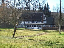
After the plague broke out in Hohenstein in 1680 , the merchant Johann Simon, who had built a forest house with his father Jacob Simon in 1679 on "Upper Haynholz" east of Hohenstein, was banned from entering Hohenstein. Thereupon he acquired larger building plots in the woods east of Hohenstein in Oberlungwitzer Flur, which he then sold to Weber and Hohensteiners who settled there. The two Counts Christian Ernst von Schönburg (1655–1718) and August Ernst von Schönburg (1666–1729) supported Simon in the construction of the settlement, which was ultimately named " Ernstthal " in honor of the two Counts . In contrast to Hohenstein, the new town of Ernstthal belonged to the Schönburg rule Glauchau , Amt Hinterglauchau , from which it was territorially separated. The mountain town of Hohenstein also largely belonged to the Glauchau rulership, albeit to the authority Fordglauchau , from which it was also territorially separated. Only seven houses in the east and south and the Waldenburger Oberwald, which today forms its own district , belonged to the Schönburg dominion of Waldenburg . These were u. a. the Bad Hohenstein, the Rote Vorwerk and the Rote Mühle. The Hüttenmühle and the Klaus-Mühle, like the Hüttengrund, belonged to Oberlungwitz at that time. The Rote Vorwerk and the Rote Mühle are south of Hohenstein. In 1799 the Masonic lodge from the Rüsdorf manor moved into the Rote Vorwerk and in 1826 it moved to Chemnitz . The “Logenstrasse” in the south of Hohenstein is reminiscent of them. To the southwest of the Roten Vorwerk is the Rote Mühle, which is located today in the street of the same name. Some sources mention the mill as early as the middle of the 14th century. Court records show that it was built before 1708 as a stamp mill with a smelter. Since the mining activity in Hohenstein was already subsiding, the Rote Mühle was probably converted into a grinding mill around 1710. The Rote Mühle has only been part of the urban area since 1927. The mineral bath Hohenstein northwest of Hohenstein is in the upper part of the Hüttengrund and was originally in the corridor of Kuhschnappel . After the Hohenstein spring was discovered around 1765, Prince Otto Karl Friedrich von Schönburg-Waldenburg bought the fountain. The spring was taken under Count Karl Heinrich von Schönburg. After it was forgotten again in the following years, the bathhouse with two buildings was built around 1830. The pharmacist from Hohenstein had residential and commercial buildings built. In 1862 Beckert sold the bathroom to the Glauchau factory owner Heinrich Beck, who set up a carpet weaving mill in the building. In 1884, 1200 bathers visited the bath. Until the foreclosure in 1913, the bathing business could be maintained with interruptions. The bathrooms were converted into a home around 1930. The restaurant was named "Oberwaldschänke". The famous writer Karl May was born in Ernstthal on February 25, 1842 . In 1880 he married his wife Emma Pollmer in the Hohenstein Church of St. Christophori. Numerous memorial plaques and the Karl May House in the house where he was born remind of Karl May's work in Hohenstein and Ernstthal . With the opening of the Chemnitz - Zwickau section of the Dresden – Werdau railway line, Hohenstein-Ernstthal station was opened to traffic on November 15, 1858 . Initially, however, the station belonged neither to Hohenstein nor to Ernstthal, but to Oberlungwitz Abbey . The station property was later bought by the city of Hohenstein.
After an administrative reform was carried out in the area of the Schönburg recession in 1878, Hohenstein came to the newly founded Saxon governorate of Glauchau in 1880 . The union with Ernstthal to form the new town of Hohenstein-Ernstthal took place in 1898. The Hohenstein Town Hall now became the administrative building of the new town, which also received a new town coat of arms. The last mining period began in Hohenstein in 1873 with the establishment of the "Lampertus including accessories at Hohenstein" union. As a result, the mine workings and daytime facilities were renewed and the "Lampertus Richtschacht" sunk to 128 meters. After the last shift in the St. Lampertus mine in 1910, the mining era in Hohenstein ended. Except for the Huthaus built in 1846, all buildings were demolished. The hut has been used as a club house since 1998 by the "Freundeskreis Geologie und Bergbau Hohenstein-Ernstthal eV", founded in 1996. In the district remember u. a. the miners monument, the "Hüttengrundstraße", the "Hüttengrund", the "Goldbachstraße" and the "Silbergässchen" at this time. In 1913 the Hohenstein-Ernstthal-Oelsnitz tram , which was operated until 1960, opened , which began at Hohenstein-Ernstthal station and then ran along Goldbachstrasse. The Hohenstein-Ernstthal , Hohenstein-Ernstthal freight station , August-Bebel-Strasse (until 1945: Schönburgstrasse ) and depot station were located in the Hohenstein corridor . In an exchange of territory between Oberlungwitz and Hohenstein-Ernstthal in 1909, the Hohenstein district was assigned the part of the Hüttengrund, which had previously belonged to Oberlungwitz, with the Klaus mill ⊙ and the Hüttenmühle, which was demolished in 2012. Through an exchange of territory with the municipality of Kuhschnappel in 1915, the part of the Hüttengrund that had previously belonged to Kuhschnappel came to the Hohenstein district. ⊙ With this parcel came the restaurant "Heiterer Blick" ⊙ and the "Bethlehemstift" ⊙ opened in 1891 at today's B 180 and the mineral bath opened in 1829/30 with the Hohensteiner Spring discovered in 1765 (streets "Im Viertel" and "Am Sachsenring" ) ⊙ to the city of Hohenstein-Ernstthal. Since then, today's B180 has formed the corridor boundary between Hohenstein and Kuhschnappel. Between 1927 and 1995, this was part of the old route of the Sachsenring race track , the origins of which go back to the Badberg square race . This was first held in 1927. The 8.71 km long road course ran counterclockwise through Hohenstein-Ernstthal to the north, and then in a westerly direction parallel to today's A4 Chemnitz - Gera . On today's federal highway 180 , it went south, then merged into the home straight in the Queckenberg curve. The autobahn north of Hohenstein-Ernstthal, now known as the A4, was built in 1937.
Since the second district reform in the GDR in 1952, Hohenstein belonged as part of the district town of Hohenstein-Ernstthal to the Hohenstein-Ernstthal district in the Chemnitz district (renamed the Karl-Marx-Stadt district in 1953 ), which was continued as the Saxon district of Hohenstein-Ernstthal in 1990 . Due to the loss of the district seat in 1994, the city of Hohenstein-Ernstthal was awarded the title of Large District Town. She came to the Chemnitzer Land district in 1994 , which was added to the Zwickau district in 2008. In 1995 the new Sachsenring circuit went into operation. On January 1, 1999, parts of Oberlungwitz (with 92 inhabitants) and St. Egidien (with 47 inhabitants from Kuhschnappel ) were incorporated.
Attractions
- Church of St. Christophori
- Old market with the town hall
- Textile and racing museum
Personalities
Web links
- Hohenstein in the Digital Historical Directory of Saxony
- History of Hohenstein-Ernstthal on the city's website
Individual evidence
- ^ The "Pfaffenberg – Oberwald" nature reserve on the Zwickau district website
- ↑ Anna von Schönburg in the Saxon biography
- ^ The Scheibenberg Mining Office in the State Archives of the Free State of Saxony
- ^ Count Christian Ernst von Schönburg in the Saxon biography
- ↑ Count August Ernst von Schönburg in the Saxon biography
- ↑ Handbook of Geography, p. 483ff.
- ^ Hohenstein in the book "Geography for all Stands", p. 897
- ^ Karlheinz Blaschke , Uwe Ulrich Jäschke : Kursächsischer Ämteratlas. Leipzig 2009, ISBN 978-3-937386-14-0 ; P. 92 f.
- ^ Book "Christian Friedrich Day: Studies on Life and Work", p. 152
- ^ Description of Hohenstein in 1828, p. 77f.
- ↑ Historical measuring table sheet of Saxony with the Roten Vorwerk, the Roten Mühle and the field name "zu Oberlungwitz"
- ↑ Historical table sheet of Saxony with the Hüttengrund near Hohenstein-Ernstthal from 1909
- ↑ Historical reviews from the city archive ( Memento from May 15, 2013 in the web archive archive.today )
- ↑ The Glauchau administrative authority in the municipal register 1900
- ^ Website of the St. Lampertus visitor mine in Hohenstein-Ernstthal
- ^ Website of the mining friends of Saxony
- ^ Hohenstein-Ernstthal in the Digital Historical Directory of Saxony
- ↑ Historical table sheet from 1909
- ↑ StBA: Changes in the municipalities in Germany, see 1999


