
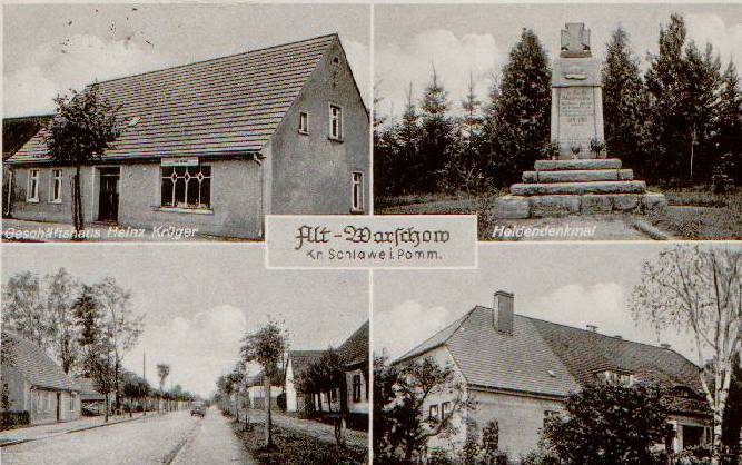
Warszkowo (Sławno)
Coordinates: 54 ° 21 ′ 57 ″ N , 16 ° 42 ′ 49 ″ O Warszkowo (German Alt Warschow ) is a village in the West Pomeranian Voivodeship in Poland . It is located in the rural municipality of Sławno ( Schlawe ) in the powiat Sławieński .
Geographical location
Warszkowo is located two kilometers east of the district town Sławno on the Polish state road 6 (formerly German Reichsstraße 2 , today also European road 28 ) Danzig - Stettin near the junction of the voivodship road 209 to Bytów ( Bütow ). The next train station is Sławno on the PKP lines No. 202 ( Danzig – Stargard ) and No. 418 ( Darłowo – Korzybie (Rügenwalde – Zollbrück) ).
Warszkowo neighbors are in the west Sławno, in the north Sławsko ( Alt Schlawe ) and Wrześnica ( Freetz ), in the east Warszkówko ( Neu Warschow ) and Tychowo ( (Wendish) Tychow ) and in the south, beyond the Wieprza ( Wipper ), Pomiłowo ( Marienthal) ).
The flat undulating landscape is mostly at a height of 35 meters above sea level. The Wieprza glacial valley encloses Warszkowo from south-west to north-west and in parts of the south and north forms the local border.
Place name
Warskow and Warschowe appear as earlier place names , then Warschow and, since the settlement of Neu Warschow, which was formerly part of the municipality, then Old Warschow . The name should come from the founder of the village and mean the seat of the war .
history
The first written mention of Old Warschow took place on March 28, 1301, as Prince Sambor III. von Rügen enfeoffed the burgrave Mattheus in Zlawena , who resided at the Alt Schlawe castle , with some villages, including Pustamin , Kuhtz , Sellen and Warschow from the area of Schlawe . In 1330 the Swenzone Jasco von Schlawe gave the village to the town of Schlawe. In 1333 the bridge was built over the Wipper below the cuckoo mill. Warschow was and remained a city village until the Stein-Hardenberg reforms at the beginning of the 19th century, namely a village under the fief of the city of Schlawe.
In 1677 31 families with 99 people lived in Warschow. 1784 there were in one field work with sheep, one pitcher, one unterschlägige watermill ( "Kuckuck mill"), 1 Vorwerk ( "Hästerkathen"), 21 farmers, 4 Kossäten , 1 Büdner and one schoolmaster with a total of 32 fires. The place became famous for its beekeeping , in 1777 140 beehives were counted.
In 1818 372 inhabitants lived in Alt Warschow, in 1864 there were already 1064, the number of which had already reached 1154 in 1895 and finally comprised 1186 in 1939.
On March 7, 1945, Alt Warschow was occupied by the Red Army in the course of taking the town of Schlawe . The first expulsions of the local population took place in October 1945. In autumn 1946 most of the former residents were evicted . Old Warschow received the Polish place name Warszkowo and was repopulated with Polish citizens. The place is now part of the Gmina Sławno in the Powiat Sławieński of the West Pomeranian Voivodeship . Until 1998 it belonged to the then Stolp Voivodeship .
Warschow District
Old Warschow, as the second largest municipality in the district in terms of population, formed its own administrative district Warschow with the registry office Warschow before 1945 . It was assigned to the Schlawe district court . The village was in the district of Schlawe i. Pom. in the administrative district of Köslin in the Prussian province of Pomerania .
Local division until 1945
Before 1945, the municipality of Alt Warschow comprised nine residential areas or localities:
- Covering shop (Polish: Mokra), farmsteads, 1.5 kilometers north of the village
- Plant (Polish: Okole, today: Warszkowo-Kolonia ), settlement that was expanded after 1945, 1 kilometer south of Warszowo, north of the formerly known as the Great Kuhmoor , on the road that branches off from the village to the south and in an arc to 209 voivodship road.
- Fuchsberg (Kłodno), farmstead, 2 kilometers south of the village, with a cutting mill
- Grünhof (Oleszno), farmstead, 400 meters north of the town exit towards Hästerkathen
- Hästerkathen (Podlaski), farm, former suburb of the town of Schlawe since around 1527, popular restaurant between 1820 and 1920
- Kuckucksmühle (Kukułka), an old watermill on the Mühlenbach (Ściegnica), which is 4 kilometers in length from the Wipper in the Tychow area, is derived from the Wipper, probably from the Middle Ages
- Red House (Uliszki), farm and beekeeping
- Schützenhaus , built in 1928/1929 with a hall for up to 2500 people, with 38 stands and a length of 150 meters, the largest shooting range in Pomerania
- Windmill , on the road to Tychow (Tychowo), 500 meters east of the exit from the town before the junction to Neu Warschow (Warszkówko), also two farms
church
Protestant church
Despite the large population, Alt Warschow did not have its own church before 1945, but was parish off to Schlawe with Neu Warschow , Alt Bewersdorf , Neu Bewersdorf and Coccejendorf . Thus the place belonged to the church district Schlawe of the church province Pomerania of the Evangelical Church of the Old Prussian Union .
Roman Catholic Church
Today the population is predominantly Roman Catholic . The ecclesiastical connection to Sławno continued until 1998. On August 28, 1998 Warszkowo became an independent parish, in which the subsidiary parish Wrześnica ( Freetz ) was included with Noskowo ( Notzkow ). The parish with approx. 2600 parish members belongs to the deanery Sławno in the Roman Catholic diocese of Köslin-Kolberg .
school
School history
Before 1945, 240 children were taught in the four-class elementary school. The schoolhouse with the teacher's apartment was the former manor house of the municipal farm. Since 1928 there was still a kindergarten in the school building. The names of the last German teachers are Ginow and Georg Küsel .
literature
- Manfred Vollack (Ed.): The Schlawe district. A Pomeranian homeland book. 2 volumes. Husum, 1988/1989.
Web links

Schulzenämter: Bobrowice (Alt Bewersdorf) | Bobrowiczki (Neu Bewersdorf) | Boleszewo (Rötzenhagen) | Brzeście (Hohenzollerndorf) | Gwiazdowo (Quäsdow) | Janiewice (Jannewitz) | Kwasowo (Quatzow) | Łętowo (Lantow) | Noskowo (Notzkow) | Pomiłowo (Marienthal) | Radosław (Coccejendorf) | Rzyszczewo (Ristow) | Sławsko (Old Schlawe) | Smardzewo (Schmarsow) | Stary Kraków (Old Krakow) | Tokary (Deutschrode) | Tychowo (Wendisch Tychow) | Warszkowo (Old Warschow) | Warszkówko (New Warsaw) | Wrześnica (Freetz) | Żabno (Blessing Mountain) | Żukowo (Suckow)
Other villages: Boleszewo-Kolonia (Rötzenhagen colony) | Chomiec (Klarenwerder) | Gwiazdówko (Little Quäsdow) | Łany (Grünheide) | Przemysławiec (Wilhelmshorst) | Rzyszczewko (New Ristow) | Ugacie (Ujatzthal) | Warszkowo-Kolonia (Old Warschow Colony) | Żukówko (New Suckow)