
Wilhelmstrasse (Altenkirchen)
| Wilhelmstrasse | |
|---|---|
|
|
|
 |
|
| Road sign | |
| Basic data | |
| place | Altenkirchen (Westerwald) |
| Created | before 1893 |
| Newly designed | 2017 |
| Hist. Names | Front alley |
| Connecting roads | Schloßplatz (northeast), Kölner Strasse (southwest) |
| Cross streets | Saynstrasse, Marktstrasse, Mühlengasse, Bleichweg, Quengelstrasse |
| Places | Marketplace |
| use | |
| User groups | Pedestrian traffic , bicycle traffic , car traffic (loading and unloading) |
| Technical specifications | |
| Street length | 418 meters |
The Wilhelmstrasse is one of the main shopping streets in the city Altenkirchen in Altenkirchen in Rhineland-Palatinate . Starting at Schloßplatz, it runs from northeast to southwest, crossing the town's market square and ending at the intersection of Kölner Strasse and Quengelstrasse, before the level crossing of the Altenkirchen-Au (Sieg) railway line .
location

Wilhelmstrasse (formerly “Vordergasse”), named in 1893, is one of the main shopping streets in Altenkirchen and has been a pedestrian zone since the mid-1980s . It was a thoroughfare until November 28, 1982 ; the connecting roads to the north ( Rathausstrasse towards Hachenburg and Wissen ), to the east ( Frankfurter Strasse to Limburg an der Lahn ), as well as to the south ( Koblenzer Strasse to Puderbach and Dierdorf ) and west ( Kölner Strasse to Hennef and Siegburg ) branched off at the ends off Wilhelmstrasse. With the construction of the inner-city bypass ( Quengelstrasse ), which was completed in 1982, Wilhelmstrasse was redesigned into a pedestrian zone over the next five years.
The northern section of Wilhelmstraße is structurally included in the Schloßplatz , which was completely redesigned with the construction of the main building of the Kreissparkasse Altenkirchen in the 1990s , the northern part of which, again narrowed to the width of the street, corresponds to "Blücherplatz", which was renamed Schloßplatz in 1996 . The new building was also the trigger for the construction of the underground car park under the square, the access to which is at the northern end of today's Wilhelmstrasse. In terms of traffic, Wilhelmstrasse and the surrounding parking lots are connected to Saynstrasse, Wallstrasse / Marktstrasse, Mühlengasse, Quengelstrasse and Weyerdamm, as well as a bus stop on Quengelstrasse. In 2014 it was decided to completely redesign the pedestrian zone ( Wilhelmstrasse / Marktplatz ); the new appearance should include a kind of amphitheater on the market square.
history
Wilhelmstrasse has probably had its character as a main street since the reconstruction of Altenkirchen after 1728, when the entire city was destroyed by a fire and only the castle, the church and a few private houses remained. Around 1815 Altenkirchen became part of Prussia and the Altenkirchen district was created. From 1822 the city was increasingly connected to the transport network. The naming of Wilhelmstrasse - like all other streets in the city center, such as Marktplatz, Marktstrasse, Mühlengasse, Quengelstrasse, Rathausstrasse and Schloßplatz - took place after the great fire on April 23, 1893. The name goes back to Wilhelm I , the King of Prussia.
Development on Wilhelmstrasse
Due to the destruction caused by the city fire of 1893, there are only a few older buildings on Wilhelmstrasse, such as the Privileged Pharmacy . The number of buildings from the late 19th and early 20th centuries in the style of late classicism , Wilhelminian style architecture and homeland security architecture was also significantly decimated by the bombing on March 7, 1945. In addition to the rebuilt and z. Some of the buildings from this period, which have been restored, are largely made up of simple residential and commercial buildings from the post-war period .
List of structures
The list of buildings includes all existing buildings on Wilhelmstrasse, sorted according to the consecutive numbering of the buildings . Buildings that no longer exist are numbered in italics .
| image | designation | location | Construction year | description | Remarks |
|---|---|---|---|---|---|
| 50 ° 41 ′ 15 ″ N, 7 ° 38 ′ 49 ″ E , | Corner of Saynstrasse | Beginning of Wilhelmstrasse, transition to Schlossplatz | |||
| Residential and commercial buildings |
Wilhelmstrasse 1 50 ° 41 ′ 14 ″ N, 7 ° 38 ′ 49 ″ E |
Residential building with round bay windows of the post-war development. | |||
|
|
Wilhelmstrasse 2 50 ° 41 ′ 15 ″ N, 7 ° 38 ′ 47 ″ E |
- | The Westerwald Bank branch ( Schloßplatz 6 ), which was opened in 1995, is located here today . | ||
| Residential and commercial buildings |
Wilhelmstrasse 3 50 ° 41 ′ 14 ″ N, 7 ° 38 ′ 48 ″ E |
Single-storey residential and commercial building ( Korte butcher's shop ) from the post-war period. | |||
| - |
Wilhelmstrasse 4 50 ° 41 ′ 14 ″ N, 7 ° 38 ′ 46 ″ E |
- | The building of the children's and youth center Altenkirchen is located here today. | ||
| Residential and commercial buildings |
Wilhelmstrasse 5 50 ° 41 ′ 14 ″ N, 7 ° 38 ′ 48 ″ E |
Residential and commercial building (approx. Interwar period) ( Balkan restaurant Deutsches Haus ) | |||
| Evangelical Children and Youth Center Altenkirchen (KiJu) |
Wilhelmstrasse 6 50 ° 41 ′ 14 ″ N, 7 ° 38 ′ 46 ″ E |
The three-storey building with apartments on the upper floors dates from the 1980s and is part of the Evangelical Community Center. | |||
| Residential and commercial buildings |
Wilhelmstrasse 7 50 ° 41 ′ 14 ″ N, 7 ° 38 ′ 47 ″ E |
Two-storey residential and commercial building ( Hairkiller hairdresser ), post-war development | |||
| Commercial building |
Wilhelmstrasse 8 50 ° 41 ′ 14 ″ N, 7 ° 38 ′ 45 ″ E |
Pavilion-like commercial building, post-war development ( Stope Lederwaren ) | |||
| Residential and commercial buildings |
Wilhelmstrasse 9 50 ° 41 ′ 14 ″ N, 7 ° 38 ′ 47 ″ E |
Two-storey residential and commercial building (formerly Vival Cuba ), post-war development | |||
| Residential and commercial buildings |
Wilhelmstrasse 10 50 ° 41 ′ 14 ″ N, 7 ° 38 ′ 45 ″ E |
The two-storey residential and commercial building ( multi-generation house "Mittendrin" ) was probably built in the 1910s. Stylistically it belongs to the late historical era, but has no distinctive wall decorations. | |||
 |
Commercial building |
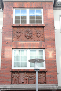
Wilhelmstrasse 11 50 ° 41 ′ 13 ″ N, 7 ° 38 ′ 46 ″ E |
1873 | Two-storey residential and commercial building ( gallery & studio Marlies Krug ) from the functionalism of the 1960s. The two-part building has a central part highlighted by a square bay window with a brick facing; This has a wall design on the front made of reliefs by the sculptor Bernhard Kloss (* 1923), which date from the 1950s. Above the door, four figures depict the typical customers of the Kuss company, which ran a long-established business with household goods and tools. In the upper part, the initials of the former business owner and the surname depicted can be seen, two putti give each other a kiss. | In the post-war years, the business premises of the Kuss company were located here, and after they moved to the outskirts, a Schlecker branch was established. |
 |
Wilhelmstrasse 12 50 ° 41 ′ 13 ″ N, 7 ° 38 ′ 44 ″ E |
Residential and commercial building (formerly Angelika Nießen fashion and costume ). The two-storey residential and commercial building was probably built in the 1910s. Stylistically it belongs to the late historical era. The house has an ornament of the facade with stone . | |||
 |
Wilhelmstrasse 13 50 ° 41 ′ 13 ″ N, 7 ° 38 ′ 46 ″ E |
see Wilhelmstrasse 11 | |||
 |
Wilhelmstrasse 14 50 ° 41 ′ 13 ″ N, 7 ° 38 ′ 44 ″ E |
Residential and commercial building ( Buch Seidel / Weltladen Altenkirchen ). The two-storey corner building, originally built in the late historical style, was largely rebuilt in the style of homeland security architecture after the war damage, dispensing with decorative attributes . It has an undecorated, round, two-story bay window that is covered by a flat-conical roof. | |||
|
Wilhelmstrasse 15 50 ° 41 ′ 13 ″ N, 7 ° 38 ′ 46 ″ E |
Two-storey residential and commercial building ( Eiscafe Garda ), post-war development | ||||
| 50 ° 41 ′ 13 ″ N, 7 ° 38 ′ 44 ″ E , | Corner of Kirchstrasse | The Kirchstrasse opens opposite the market square between the houses Wilhelmstrasse 14 & 16 | |||
|
Wilhelmstrasse 16 50 ° 41 ′ 13 ″ N, 7 ° 38 ′ 43 ″ E |
Residential and commercial building ( Becker perfumery ). Single-storey residential and commercial building, post-war development | ||||
 |
Wilhelmstrasse 17 50 ° 41 ′ 13 ″ N, 7 ° 38 ′ 45 ″ E |
Residential and commercial building ( Optik Bruder ). Two-storey residential and commercial building; Reconstruction (with borrowings from homeland security architecture ) in the 1950s. The house has a square, two-storey bay window with visible stone consoles on the market side . | |||
| 50 ° 41 ′ 12 ″ N, 7 ° 38 ′ 44 ″ E , | Corner of the market square | Between the houses Wilhelmstrasse 17 & 19 | |||
|
Wilhelmstrasse 18 50 ° 41 ′ 13 ″ N, 7 ° 38 ′ 43 ″ E |
Residential, office and commercial building ( law firm Steinstrass und Partner / Allianz insurance agency ). Two-storey residential and commercial building, post-war development | ||||
 |
Wilhelmstrasse 19 50 ° 41 ′ 12 ″ N, 7 ° 38 ′ 43 ″ E |
Two-storey residential and commercial building ( Fahrrad Neitzert ), post-war development | |||
|
Wilhelmstrasse 20 50 ° 41 ′ 13 ″ N, 7 ° 38 ′ 42 ″ E |
Two-story office and commercial building ( LBS ), development in the functionalism style of the 1960s. | ||||
|
Wilhelmstrasse 21 50 ° 41 ′ 12 ″ N, 7 ° 38 ′ 42 ″ E |
Residential and commercial building ( Woll & Perlenecke B. Gerhardus ). The two-storey building was probably built in the 1950s. | ||||
 |
Wilhelmstrasse 22 50 ° 41 ′ 13 ″ N, 7 ° 38 ′ 41 ″ E |
The narrow, two-storey residential and commercial building ( Marion Eich Brauer Pub ) was probably built in the 1920s. | |||
|
Wilhelmstrasse 23 50 ° 41 ′ 12 ″ N, 7 ° 38 ′ 42 ″ E |
Residential and commercial building ( Laura Young Fashion ). The two-storey building was probably built in the 1950s. | ||||
|
Wilhelmstrasse 24 50 ° 41 ′ 13 ″ N, 7 ° 38 ′ 41 ″ E |
Residential and commercial building ( Schmitt bookstore ). The single-storey residential and commercial building was probably built in the 1920s, but was shaped by rebuilding and renovations in the post-war period. | ||||
| Residential building |
Wilhelmstrasse 25 50 ° 41 ′ 12 ″ N, 7 ° 38 ′ 42 ″ E |
Residential, medical and commercial building ( hairdressing salon JH Haarmonie ). The two-storey building was probably built in the 1950s. | |||
| Residential building |
Wilhelmstrasse 26 50 ° 41 ′ 12 ″ N, 7 ° 38 ′ 41 ″ E |
The single-storey residential and commercial building ('' empty ''). was probably built in the 1920s. | |||
 |
Wilhelmstrasse 27 50 ° 41 ′ 12 ″ N, 7 ° 38 ′ 42 ″ E |
The two-storey residential and commercial building ( La dolce vita ice cream parlor ) was probably rebuilt in the 1950s. The ribbon windows are emphasized with simple decorative elements made of exposed brick. | The residential building at Wilhelmstrasse 27a was the residential and commercial building of the Jewish families of the brothers Rudolf and Hans-Ludwig Davis, who owned a shoe shop there and emigrated to Palestine after the forced sale (around 1938/39) . | ||
|
Wilhelmstrasse 28 50 ° 41 ′ 12 ″ N, 7 ° 38 ′ 40 ″ E |
The single-storey residential, office and commercial building ('' empty '') was probably built in the 1920s. | ||||
|
Wilhelmstrasse 29 50 ° 41 ′ 12 ″ N, 7 ° 38 ′ 41 ″ E |
The two-storey residential and commercial building (formerly FIRST travel agency ) was probably built in the 1930s. | ||||
|
Wilhelmstrasse 30 50 ° 41 ′ 12 ″ N, 7 ° 38 ′ 40 ″ E |
The narrow, single-storey residential and commercial building (formerly Beauty ) was probably built in the 1910 or 20s with a brick facade. | ||||
|
Wilhelmstrasse 31 50 ° 41 ′ 11 ″ N, 7 ° 38 ′ 40 ″ E |
The two-storey residential and commercial building ( Schuhhaus Schmidt ) was probably built in the 1930s. | ||||
|
Wilhelmstrasse 32 50 ° 41 ′ 12 ″ N, 7 ° 38 ′ 40 ″ E |
Residential, medical and commercial building ( Optik Gansauer / Dr. Wehler ). The wide, two-story corner house was probably built in the 1950s. | ||||
 |
Wilhelmstrasse 33 50 ° 41 ′ 11 ″ N, 7 ° 38 ′ 40 ″ E |
The three-story residential and commercial building ( Deutscher Kinderschutzbund Kreisverband Altenkirchen eV ) was probably built in the 1910s. Stylistically it belongs to the late historical era. The house has a decoration of the soffits with colored stone . The gable of the risalit is clad in slate. | |||
| 50 ° 41 ′ 12 "N, 7 ° 38 ′ 40" E | Corner of the Weyerdamm | between Wilhelmstrasse 32 & 34 | |||
 |
Wilhelmstrasse 34 50 ° 41 ′ 12 ″ N, 7 ° 38 ′ 39 ″ E |
1956 | Residential and commercial building ( Willi Wick, optician ). The wide, two-story corner house was built in the mid-1950s on the foundations of the previous building. | ||
 |
Residential and commercial building |
Wilhelmstrasse 35 50 ° 41 ′ 11 ″ N, 7 ° 38 ′ 39 ″ E |
Two-storey residential and commercial building (corner house) (formerly City Grill ) with references to homeland security architecture probably dates from the 1910s. The house has a hexagonal and two-storey bay window on the corner side, which was closed with a pointed tower, and two dormers on the front side. | ||
| Residential building |
Wilhelmstrasse 36 50 ° 41 ′ 12 ″ N, 7 ° 38 ′ 39 ″ E |
Residential and commercial building ( Pizza Döner Kebaphaus ), post-war architecture. | |||
| 50 ° 41 ′ 11 "N, 7 ° 38 ′ 39" E | Corner of Marktstrasse | between Wilhelmstrasse 35 & 37 | |||
 |
Privileged pharmacy |
Wilhelmstrasse 37 50 ° 41 ′ 11 ″ N, 7 ° 38 ′ 39 ″ E |
around 1730 | Residential and commercial buildings ( privileged pharmacy ) | Architectural monument: The privileged pharmacy , built around 1730, is a residential and commercial building in the style of a baroque plastered half-timbered building. |
|
Wilhelmstraße 38 |
Residential, office and commercial building ( Nikolaos Manos Gaststätte ), probably 1930s, rebuilt in the 1950s. | ||||
 |
Wilhelmstraße 39 |
1902 | Residential and commercial building ( Idea + Flemmer game ). Stylistically, the building belongs to historicism. The corner house is in an exposed position that defines the street space. A square corner bay dominating the corner building is positioned above a corner axis on the first floor . Like the gable wall on the left side of the house, it has a stylized parapet decoration and a pointed tower. | ||
 |
Wilhelmstraße 40 |
Residential and commercial building ( laundry ) in homeland security style with gables drawn into the roof overhang. The house was rebuilt in the pre-war style after the war damage. | |||
| Corner of Mühlengasse | |||||
|
Wilhelmstraße 41 |
Three-story residential, office and commercial building (formerly Raiffeisenbank ) from the 1970s. Its asymmetrical design language and the slate cladding of the building are characteristic. The post-war development with the “Eckschank” restaurant was demolished for the new building in the 1970s. | ||||
|
Wilhelmstraße 42 |
Residential and commercial building ( Peter Schmidt Wohnen ), Bachkriegsbauung. | ||||
|
Wilhelmstraße 43 |
1770 | Residential and commercial building ( new pharmacy ). Post-war building with attached half-timbered decoration. | |||
|
Wilhelmstraße 44 |
Residential and commercial building ( KiK ), post-war development | ||||
 |
Residential building |
Wilhelmstraße 45 |
1901 | Residential and commercial building (formerly Langenbach & Feisel ). The three-story residential and commercial building was built in 1901. Stylistically it belongs to the late historical era. The house has an elaborate decoration of the facade with stone . | |
| Residential building |
Wilhelmstraße 46 |
Residential and commercial building ( KiK branch ), post-war reconstruction ( Wilhelmstrasse 44-46 ); The stairwell set off to the side of the main building is striking. | The residential building at Wilhelmstrasse 46 was the residential and commercial building of the Jewish family Julius (1871–1932) and Johanna Grünebaum (1871–1941), who owned a department store there, which their sons sold to Erich Becker and Karl Kottmann on January 20, 1936 and subsequently emigrated to the United States. | ||
 |
Wilhelmstraße 47 |
Single-storey residential and commercial building ( Vanity Modevertrieb / caro ) from the 1920s or 1930s. The gable no longer has the earlier decor. Only the window reveals are decorated in the style of the time. | |||
|
Wilhelmstraße 48 |
Two-storey residential, office and commercial building ( Provinzial Eichelhardt ) from the 1930s. Reconstruction after war damage in the 1950s | ||||
 |
Wilhelmstraße 49 |
Residential and commercial building ( Chill Boutique ) from the 1910s in style borrowed from country house and homeland security architecture . The risalit gable wall and the square bay window are designed in half-timbered construction. | |||
|
Wilhelmstraße 50 |
Residential and commercial building ( Biermann's Inn ), post-war reconstruction | ||||
|
Wilhelmstraße 51 |
Residential and commercial building ( Herrenmoden Iserlohe ) from the 1920s or 30s. | ||||
 |
Wilhelmstraße 52 |
Single-storey residential and commercial building ( Dörner Moden ). | |||
| Corner of Bleichweg | |||||
|
Wilhelmstraße 53 |
The two-story residential and commercial building ( KODI drugstore ), which dates from the 1950s, has a simple square bay window facing Bleichweg . The simple, single-storey extension to Wilhelmstrasse 55 ( Schumacher bakery ) is more recent. | ||||
 |
Wilhelmstraße 54 |
1892 | Single-storey residential and commercial building ( Dörner Moden ); it has a no-frills brick facade. | ||
 |
Residential building |
Wilhelmstraße 55 |
19 .. | Residential and commercial building ( Trendschmuck jeweler ) | |
 |
Residential building |
Wilhelmstraße 56 |
The triangular, single-storey residential and commercial building ( Dörner Moden ) dates from the 1930s. | ||
 |
Residential building |
Wilhelmstraße 57 |
Residential and commercial building ( BT Integra Ltd. ) in the style of post-war architecture. | ||
| 50 ° 41 ′ 11 "N, 7 ° 38 ′ 33" E | Corner of Quengelstrasse | End of Wilhelmstrasse |
See also
literature
- Altenkirchen, address book of the Verbandsgemeinde Altenkirchen 1969. Contains the city of Altenkirchen and 24 parishes such as B. Almersbach, Bachenberg, Busenhausen, Eichelhardt, Igelberg, Isert, Michelbach, Ölsen, Sörth, Stürzelbach, Volkerzen. Publishing house HE Kasper & Co., Cologne,
Web links
Individual evidence
- ↑ a b Historic Quarter - City.Life Volume 1: Wilhelmstrasse - Market Square - Palace Square . Altenkirchen, 2017.
- ↑ In 1893, Bahnhofstrasse, Dieperzbergweg, Frankfurter Strasse, Gartenstrasse, Hochstrasse, Hohlweg, Johannisberg, Kirchstrasse ( renamed Schulstrasse on October 9, 1930 ), Koblenzer Strasse, Kölner Strasse, Kumpstrasse, Marktplatz, Marktstrasse, Mühlengasse, Quengelstrasse, Rathausstrasse, Schloßplatz, Wallstrasse and Wiedstrasse . Source: Address book for the city and the district of Altenkirchen . Lorsbachs (ed.). Siegen 1898
- ↑ Host Ascheid: Completion of the pedestrian zone . In: Heimat-Jahrbuch of the Altenkirchen district and the neighboring communities 1982 . Publisher: Neunkirchen, 1982, p. 60 f.
- ↑ Jürgen Kolb, Horst Ascheid: The Altenkirchener Schloßplatz. Before, its change, today . In: Heimat-Jahrbuch of the Altenkirchen district and the neighboring communities 1998 . Published by Neunkirchen, 1998
- ↑ Altenkirchen pedestrian zone gets a new face (2014) in Rhein-Zeitung
- ↑ 1964 said in the reports on German regional studies : The number of restaurants is falling in Wilhelmstrasse; In the Kölner Straße, the car dealerships on : Quoted from: Reports on German regional studies, Volume 33 . Self-published by the German Academy for Regional Studies, 1964
- ^ Altenkirchen A homestead becomes a town in Regionalgeschichte.net
- ↑ Source: Address book for the city and the district of Altenkirchen. Lorsbachs (ed.), Siegen 1898
- ^ Eberhard Blohm: Jewish families from the communities of the Verbandsgemeinde Altenkirchen. Weyerbusch 2008, p. 45 f.
- ^ Eberhard Blohm: Jewish families from the communities of the Verbandsgemeinde Altenkirchen . Weyerbusch 2008, p. 56