Soroksár
|
Soroksár Market XXIII. Budapest district |
|||
|
|||
| Basic data | |||
|---|---|---|---|
| State : | Hungary | ||
| Region : | Central Hungary | ||
| County : | Budapest | ||
| Coordinates : | 47 ° 24 ′ N , 19 ° 6 ′ E | ||
| Area : | 40.78 km² | ||
| Residents : | 20.004 (Jan. 1, 2011) | ||
| Population density : | 491 inhabitants per km² | ||
| Postal code : | 1231-1239 | ||
| KSH kódja: | 34139 | ||
| Structure and administration (status: 2014) | |||
| Community type : | district | ||
| Structure : | Districts
|
||
| Mayor : | Ferenc Geiger (SCSZ) | ||
| Postal address : | Grassalkovich út 162 1239 Budapest |
||
| Website : | |||
| (Source: A Magyar Köztársaság helységnévkönyve 2011. január 1st at Központi statisztikai hivatal ) | |||
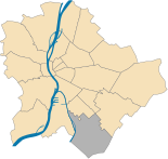
Soroksár ( German : Market ) is the twenty-third district (XXIII. District) in Budapest . The youngest of the twenty-three Budapest districts was founded in 1994 by the XX. District separated. Soroksár was an independent large municipality until it was incorporated into the capital in 1950 .
Location and dates
Soroksár lies in the Pest plain. In the north of the 23rd district lies the 20th district and in the west the Soroksár junction of the Danube forms the border. The Gyáli Brook , which has been straightened and heavily polluted since the 1970s, flows into it. The 21st district and Szigetszentmiklós are on the opposite bank . In the south, the towns of Dunaharaszti , Alsónémedi and Gyál border the district and to the east is the 18th district .
Soroksár is a rather quiet part of the city as the larger streets run on the edge of the district. In the west this is the Soroksári út and in the east the M5 motorway . Important means of transport are the Ráckever HÉV and the Budapest- Kiskunhalas - Kelebia railway line . Both lines have stops in the center.
The 23rd district consists of the districts Millenniumtelep , Soroksár and Soroksár-Újtelep .
history
The place Soroksár was destroyed under the Turkish rule. The resettlement of German immigrants did not begin until 1724. The area came into the possession of Antal Grassalkovich , which delayed the speed of settlement. In the middle of the 18th century Soroksár became a village again. Under Maria Theresa it received market rights and became a minority . At the end of the 19th century it received the rank of a large municipality in the Ráckave district of the former Pest-Pilis-Solt-Kiskun county . In addition to the separated branch of the Danube, there were 1,366 houses with 12,143 residents in 1891. Of these, 4410 were of Hungarian , 7120 of German and 150 of Slovak descent. The proximity to the capital favored economic development. At that time Erzsébetfalva , Kossuthfalva and Gubacsipuszta belonged to Soroksár. As a result of the Second World War , 3898 Hungarian Germans were expelled. On January 1, 1950, Soroksár was annexed to Budapest and incorporated into the 20th district. On September 27, 1992, the separation of Pesterzsébet was approved in a referendum. The population of the 23rd district thus created elected the first municipal parliament on December 11, 1994. Acting mayor in 2008 was Ferenc Geiger from the “Association of Soroksár Civil Organizations and Persons” ( Soroksári Civil Szervezetek és Személyek Egyesülete ).
Sports
The official sports club of the 23rd district is Soroksár SC . The football club retired from the NB2 (2nd league in Hungary) in the 2007-2008 season. In Soroksár there is still the weightlifting club Soroksári Súlyemelő és Szabadidősport Egyesületnek (SoSE), which has produced 50 national champions as well as numerous European and world champions since it was founded in 1995. He is one of the most successful clubs in the country. The International Soroksár Cup in Weightlifting Soroksár Kupa Nemzetközi Súlyemelő verseny is organized in the vicinity of the club every year . In 2008 more than 100 weightlifters participated.
Important streets and places
- Hősök tere
- Grassalkovich út
- Haraszti út
- Szentlőrinci út
- Vecsési út
Building:
- "Pleban Church Nagyboldogasszony" ( Nagyboldogasszony Plébániatemplom )
- "Mihály Táncsics Community Center" ( Táncsics Mihály Művelődési Ház )
- “Home culture center” ( Otthon Kulturális Központ ) in the former cinema
Twin cities
Individual evidence
Web links
- Soroksár. City of Nürtingen, accessed on December 19, 2008 (German).
- Emigration from Baden to Soroksár. Wirth, Anton, accessed on September 23, 2014 (German).
- Aerial photo gallery over Soroksár


